
Downtown Form-Based Code
September 19, 2016
Part 3. Regulating Plans
DFD 301. Rules for Regulating Plans
-
A.Purpose and Intent
-
1.A Regulating Plan is the controlling document and principal tool for implementing this Code.
-
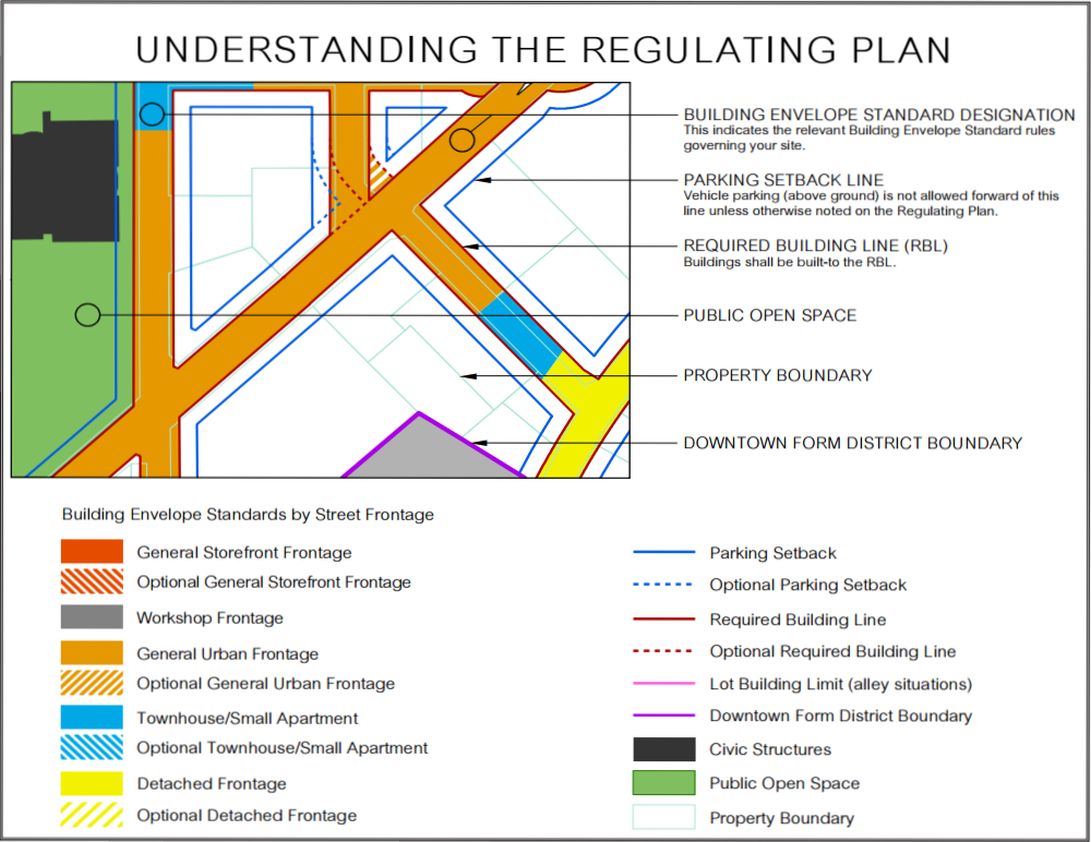
2.The Regulating Plan makes the development standards place-specific, by allocating the Building Envelope Standards (BES) and delineating the public spaces. A Regulating Plan identifies: the boundaries for the district; new and existing streets; the Required Building Line and Parking Setback Line; and the Street-Type Specifications throughout the plan area.
-
3.A Regulating Plan may identify specific characteristics assigned to a lot or building site and may identify additional regulations (and opportunities) for lots in specific locations, as well as exceptions to the BES or other standards.
-
-
B.Regulating Plan Key
| DFD 301.B Understanding the Regulating Plan |
|---|
 |
-
C.Building Envelope Standards (BES)
-
1.Building Envelope Standards are designated on the Regulating Plan by Street Frontage.
-
2.In determining the allocation and, thereby, the form and mixed-use character of the district, attention has been be paid to both the physical context (what goes next to what) and diversity of allowed/required uses.
-
-
D.Streets, Blocks & Alleys
-
1.Streets
The street specifications may be shown on an additional version/plot of the Regulating Plan - a Street Specification Plan. Street configurations called out there and in the Urban Space Standards and or Regulating Plan may or may not be immediately constructed. They shall be placed into the system such that, when reasonable for the City’s street maintenance/reconstruction plan, they can be rationally constructed.
-
a.Additional streets may be added to the Regulating Plan to create a smaller Block pattern.
-
b.Where new streets (not in existence as of 2010) are shown/drawn on the Regulating Plan as optional, they shall be considered optional and at the discretion of the property owner(s).
-
c.Where new streets are designated on the Regulating Plan without an asterisk, they are critical to the working of the Form District and shall be considered mandatory. While the street infrastructure may not be constructed until some point in the future, the RBL, and other regulations of the Regulating Plan shall be respected.
-
d.New streets shall be public.
-
e.Additional streets may be added to the Regulating Plan to create a smaller Block pattern; however, no streets may be deleted without being replaced.
-
f.Where a new street or a street stub-out is shown on the Regulating Plan, no other curb cut/intersecting street is permitted within 125 feet.
-
g.All lots shall share a frontage line with a Street-Space.
-
-
2.Blocks
-
a.No block face shall have a length greater than 350 feet without an Alley, Common Drive or access easement, or Pedestrian Pathway providing through-access to another Street-Space, Alley or Common Drive, or designated Conservation Line. Individual lots with less than 100 feet of Street Frontage are exempt from the requirement to interrupt the Block face; those with over 200 feet of Street Frontage shall meet the requirement within their lot, unless already satisfied within that Block face.
-
b.Unless otherwise specified on the Regulating Plan, driveways and Alleys are not permitted within 125 feet of another street, Alley, or driveway (centerline to centerline). This distance shall be increased to 175 feet on Metcalf Avenue and 75th Street (centerline to centerline). Driveways located on Alleys or Common Drives are exempt from these requirements.
-
c.In no case shall a driveway or alley be located within the Functional Area Of An Intersection. The Director may grant exceptions to these requirements where unique circumstances exist related to ownership and/or development patterns which prevent strict compliance with these requirements.
-
d.The average perimeter of the Blocks shall not exceed 1500 feet. Blocks shall be measured at the external/RBL lines (or along public right-of-ways, other public, agricultural, conservation and private lands where an RBL is not present). All lots and/or contiguous lots shall be considered to be part of a Block for this purpose.
-
-
3.Alleys
-
a.Alleys or Common Drives must provide access to the rear of all lots, except where lots are on a perimeter common to non-developable or Conservation Lands or where a lot has streets on three sides and the absence of an Alley or Common Drive would not deprive an adjacent neighbor of rear lot access.
-
b.For new Alleys (or Common Drives), public access, public utility, and drainage shall be dedicated via an easement.
-
c.Alleys may be incorporated into (rear) parking lots as standard drive aisles. Access to all properties adjacent shall be maintained. Access between parking lots across property lines is required.
-
d.Where an Alley does not exist and is not feasible to construct at the time of redevelopment of any property, but is determined by the City to be needed, the applicant shall record an easement (utility and access) for the Alley right-of-way within the rear setback. The area within the rear setback shall be maintained at a minimum by:
-
i.Providing routine landscape maintenance to the area.
-
ii.Keeping the area clear of debris, stored materials, and stored or parked vehicles.
-
-
-
Any amendment or change to the Regulating Plan, beyond those specified above, will be a zoning map amendment of this code. See Part Part 2, DFD 207. Amendments to the Form-Based Code.
| DFD 301.D Downtown Form District Regulating Plan |
|---|
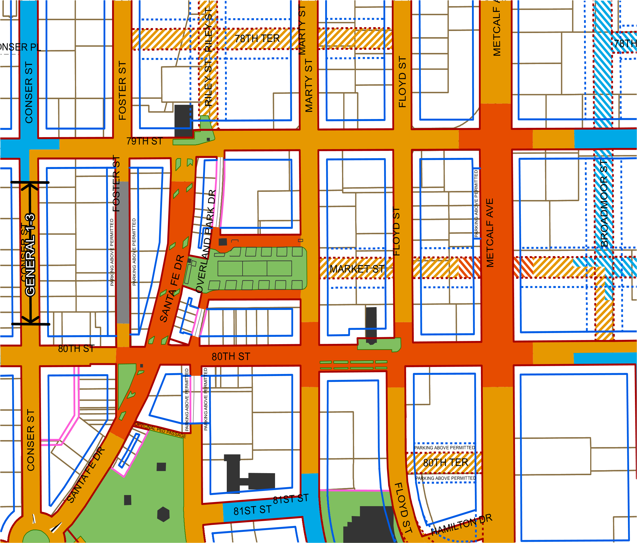 |
This portion of the Downtown Form District Regulating Plan is shown for illustrative purposes only, refer to the City for specific Regulating Plan information.
Click here to access the current Regulating Plan.
Effective on: 1/1/1901