
Mixed-Use Design Standards
July 1, 2009
- MUDS 2.1 Purpose
- MUDS 3.1 Applicable Documents
- MUDS 3.2 Use of This Document
- MUDS 3.3 Procedures
- MUDS 3.4 Mixed-Use Development Types
- MUDS 3.5 Applicable Standards
- MUDS 4.1 Sub-Zones
- MUDS 4.2 Allowed & Required Sub-Zones
- MUDS 4.3 Regulating Plan
- MUDS 4.4 Allowed Building Types
- MUDS 4.5 Required Design Elements
- MUDS 4.6 Permitted Uses & Intensity of Use
- MUDS 4.7 Project Design Manual
- MUDS 5.1 Block Size
- MUDS 5.2 Lot Size
- MUDS 5.3 Building Envelopes
- MUDS 5.4 Building Height
- MUDS 6.1 Existing Trees & Vegetation
- MUDS 6.2 Street Trees: Species & Standards
- MUDS 6.3 Street Trees: Planting Conditions
- MUDS 7.1 Parking Requirements
- MUDS 7.2 Parking Lots & Garages
- MUDS 8.1 Definitions
- MUDS 9.1 Mixed-Use Street Type Precedents
- MUDS 9.2 Pedestrian Realm
- MUDS 9.3 Mixed-Use Development Examples
- MUDS 9.4 Checklist
MUDS 2.1 Purpose
| Development Types | ||
|---|---|---|
| Mixed-Use Corridor Development | Mixed-Use Center | Mixed-Use Neighborhood |
MUDS 2.1.1 Purpose.
The Mixed-Use District (MXD) establishes and encourages innovative mixed-use development as an alternative to typical post World War II suburban, use-segregated developments. Specifically, the MXD is intended to be used for the creation of developments that:
-
1.Create a dynamic walkable, mixed-use environment.
-
2.Provide a range of housing choices in close proximity to each other.
-
3.Create quality usable public spaces.
-
4.Ensure high standards of design for buildings, infrastructure, and landscaping.
-
5.Guarantee a high degree of pedestrian and vehicular connectivity.
-
6.Locate buildings close to the street, so that streets and squares feel enclosed.
-
7.Utilize the streets for on-street parking.
-
8.Expedite the development process.
-
9.Provide slow-speed streets.
MUDS 2.1.2 Adherence to Standards
New developments, redevelopments, or existing neighborhoods desiring to develop or rezone to a Mixed-Use District must exhibit adherence to these standards.
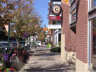
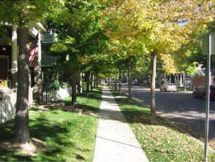
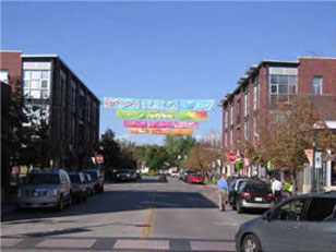
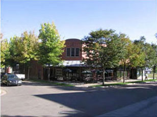
| Examples of Permitted Development in Mixed Use Districts | |
|---|---|
|
|
 |
|
|
 |
Effective on: 1/1/1901
MUDS 3.1 Applicable Documents
| Development Types | ||
|---|---|---|
| Mixed-Use Corridor Development | Mixed-Use Center | Mixed-Use Neighborhood |
| Applicable Documents |
|---|
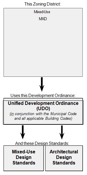 |
MUDS 3.1.1 Unified Development Ordinance.
The Unified Development Ordinance (UDO) governs development for all zoning classifications.
MUDS 3.1.2 Mixed-Use Design Standards.
The Mixed-Use Design Standards, in conjunction with the Municipal Code, shall govern site design in the MXD zoning district. Compliance with the UDO and any applicable building codes is required by the Municipal Code.
MUDS 3.1.3 Architectural Design Standards.
The Architectural Design Standards, in conjunction with the Municipal Code, shall govern architectural design in the MXD zoning district. Compliance with the UDO and any applicable building codes is required by the Municipal Code.
MUDS 3.1.4 Conflict in Standards.
In any conflict in standards between the mixed-use design standards, the architectural design standards, or the UDO, the mixed-use standard shall apply.
Effective on: 1/1/1901
MUDS 3.2 Use of This Document
| Development Types | ||
|---|---|---|
| Mixed-Use Corridor Development | Mixed-Use Center | Mixed-Use Neighborhood |
MUDS 3.2.1 General Provisions.
The first section of the document contains general provisions related to development and design standards concerning applicability and the application and review process.
MUDS 3.2.2 Mixed-Use Development Types.
Each MXD shall be classified as a one of the defined development types. Mixed-Use Design Standards are applicable based on mixed-use development type.
MUDS 3.2.3 Applicable Standards.
A list of applicable standards for each mixed-use development type is listed in the General Provisions section; this list of standards shall be the governing list of applicable standards for each mixed-use development type.
MUDS 3.2.4 Page Tabbing.
Each page is tabbed with the applicable mixed-used development type for the standard. This tabbing is provided as a quick-reference tool for document-users. This tabbing, however, shall not constitute a specific standard’s applicability to a mixed-use development type; the list of applicable standards for each mixed-use development type is provided in the general provisions section of the document.
MUDS 3.2.5 Standard Format.
Each page or set of pages consists of standards relating to a particular topic; each topic consists of an intent and a standard.
Effective on: 1/1/1901
MUDS 3.3 Procedures
| Development Types | ||
|---|---|---|
| Mixed-Use Corridor Development | Mixed-Use Center | Mixed-Use Neighborhood |
MUDS 3.3.1 Mixed Use Preliminary Development Plan.
Submission Requirements and Contents for Rezoning or Revised Preliminary Development Plan Applications.
- 1.All rezoning applications and revised preliminary development plans shall provide all submittal requirements as provided in Section 18.140.190 of the Unified Development Ordinance.
- 2.In addition to those requirements listed above all rezoning and revised preliminary development plan applications shall submit the following plans and manuals:
- A.Regulating Plan
- B.Building type Plan
- C.Street Type plan
- D.Utility Location Strategy
- E.Project Design Manual
- F.Additional plans or studies deemed necessary by the Director of Planning and Development Services
MUDS 3.3.2 Modification to Approved Plans.
- 1.After rezoning, the Director of Planning and Development Services may grant approval for changes to the approved development submittal that does not conflict with the approved plans or manuals of the project, subject to the following criteria:
- A.Internal sub-zones in an MXD development may be changed administratively if no internal property or units have been sold to a separate entity.
- B.Perimeter sub-zones in an MXD development may be changed to a less intensive sub-zone without a public hearing. Any changes of perimeter sub-zones which result in a more intensive sub-zone being located within 200 feet of the perimeter property line of an MXD zoned development shall result in a revised preliminary plan subject to the requirements found in the UDO Section 18.140.150. For the purpose of the section the MXD sub-zones from the most intensive to the least intensive shall be as follows:
- Core
- Center
- General
- Edge
- Civic
- 2.The Governing Body, Planning Commission, or Director of Planning and Development Services, shall approve amendments to the MXD plans and manuals upon a determination that the following criteria have been satisfied:
- A.The plan conforms to the applicable MXD regulations and any other adopted plans and policies.
- B.The plan complies with the criteria set forth in UDO Section 18.140.180 C - Consideration of site plans.
- C.
- D.All submission requirements have been met.
MUDS 3.3.3 Approval of Mixed Use Final Development Plans.
After approval of the Mixed Use preliminary plan all Mixed Use developments requiring a building permit, site development permit or sign permit, may be approved administratively by the Director of Planning and Development Services subject to meeting the approved plans and project design manual. Applications which have been denied by the Director of Planning and Development Services, may appeal the Director’s decision to the Planning Commission, provided written notice is provided to the Director within 14 days following the Director’s decision. In the event an application is appealed to the Planning Commission, the procedure outlined in 18.140.490(A) 1-5 shall be followed.
MUDS 3.3.4 Mixed Use Development Plans: Content and Submission Requirements.
Application for Mixed Use final development plans may only be submitted for property that is zoned to the Mixed Use District. Mixed use development plans shall include the information listed in 18.140.210 to the extent that it is pertinent to the application.
MUDS 3.3.5. Modification to Allow Alternative Compliance.
In addition, the Director of Planning and Development Services may waive or modify any design standard contained in these Mixed Use Design Standards to encourage the implementation of alternative or innovative practices that implement the intent of the modified standard(s) and provide equivalent public benefits without significant adverse impacts on surrounding development.
MUDS 3.3.6. Modification to Previously-Approved Mixed-Use Development Plans.
For properties zoned to the Mixed-Use District prior to adoption of these Mixed-Use Design Standards, any change that requires a Revised Preliminary Plan with notification based upon the criteria set forth in Section 18.140.200.A.3 of the Unified Development Ordinance, the Revised Preliminary Plan shall meet all standards and requirements found in the City of Overland Park Mixed-Use Design Standards.
Effective on: 1/1/1901
MUDS 3.4 Mixed-Use Development Types
| Development Types | ||
|---|---|---|
| Mixed-Use Corridor Development | Mixed-Use Center | Mixed-Use Neighborhood |
MUDS 3.4.1 Intent.
Developments vary in both size and location. Due to these differences in scale and context, all standards for a mixed-use district may not be equally applicable to all mixed-use developments. Consequently, different scales of mixed-use development should be defined based on a development’s size and location; design standards should vary as necessary for the different development types.
Standard:
MUDS 3.4.2 Mixed-Use Development Types.
Each MXD shall be classified as one of the defined mixed-use development types based on its size and location. Mixed-Use Design Standards are applicable based on mixed-used development type. There are three mixed-use development types:
- Mixed-Use Corridor Development
- Mixed-Use Center
- Mixed-Use Neighborhood
MUDS 3.4.3 Mixed-Use Corridor Development.
A Mixed-Use Corridor Development is an MXD development that is no larger than 10 acres in gross land area. A Mixed-Use Corridor Development shall be located within a Vision Metcalf Master Plan node or shall abut a thoroughfare, super-collector, or collector.
MUDS 3.4.4 Mixed-Use Center.
A Mixed-Use Center is an MXD development that is larger than 10 acres but less than 40 acres in gross land area. A Mixed-Use Center shall be located within a Vision Metcalf Master Plan node or shall abut a thoroughfare, super-collector, or collector.
MUDS 3.4.5 Mixed-Use Neighborhood.
A Mixed-Use Neighborhood is an MXD development that is no less than 40 acres in gross land area. A Mixed-Use Neighborhood may be located at any location within the city.
MUDS 3.4.6 Gross Land Area.
Gross land area is measured to the centerline of public streets.
| Allowed Locations | ||||
|---|---|---|---|---|
| Mixed-Use Development Type |
Development Size (gross land area) |
Allowed within Vision Metcalf Nodes |
Allowed if abutting a Thoroughfare, Super-Collector, or Collector |
Allowed City-Wide |
| Mixed-Use Corridor Development |
10 acre max. | YES | YES | NO |
| Mixed-Use Center |
Greater than 10 acres; less than 40 acres |
YES | YES | NO |
| Mixed-Use Neighborhood |
40 acre min. | YES | YES | YES |
Mixed-Use Development Type Examples
Note: The plans provided are for explanatory purposes only; these plans do not represent projects that are currently in the planning or development phase. No plan included shall be construed to represent development that is proposed or required to occur on a particular site.
| Mixed-Use Corridor Development | |
 |
|
| Development Specifications | |
| Gross Land Area | 6 acres |
| Site is within a Vision Metcalf Node? | Yes |
| Site abuts a thoroughfare, super-collector, or collector? | Yes |
| Mixed-Use Center | |
|---|---|
.jpg) |
|
| Development Specifications | |
| Gross Land Area | 35 acres |
| Site is within a Vision Metcalf Node? | No |
| Site abuts a thoroughfare, super-collector, or collector? | Yes |
| Mixed-Use Neighborhood | |
.jpg) |
|
| Development Specifications | |
| Gross Land Area | 50 acres |
| Site is within a Vision Metcalf Node? | Yes |
| Site abuts a thoroughfare, super-collector, or collector? | Yes |
Effective on: 1/1/1901
MUDS 3.5 Applicable Standards
| Development Types | ||
|---|---|---|
| Mixed-Use Corridor Development | Mixed-Use Center | Mixed-Use Neighborhood |
MUDS 3.5.1 Applicable Standards.
The Mixed-Use Design Standards are applicable to all mixed-used development types. The following list of standards shall be the governing list of applicable standards for all mixed-use development types.
| Section | MXD Design Standards for all Mixed-Use Development Types |
|---|---|
| MUDS 4.2 | Allowed & Required Sub-Zones |
| MUDS 4.3 | Regulating Plan |
| MUDS 4.4 | Allowed Building Types |
| MUDS 4.5 | Required Design Elements |
| MUDS 4.6 | Permitted Uses & Intensity of Use |
| MUDS 4.7 | Project Design Manual |
| MUDS 5.1 | Block Size |
| MUDS 5.2 | Lot Size |
| MUDS 5.3 | Building Envelopes |
| MUDS 5.4 | Building Height |
| MUDS 6.1 | Existing Trees & Vegetation |
| MUDS 6.2 | Street Trees: Species & Standards |
| MUDS 6.3 | Street Trees: Planting Conditions |
| MUDS 7.1 | Parking Requirements |
| MUDS 7.2 | Parking Lots & Garages |
Effective on: 1/1/1901
MUDS 4.1 Sub-Zones
| Development Types | ||
|---|---|---|
| Mixed-Use Corridor Development | Mixed-Use Center | Mixed-Use Neighborhood |
MUDS 4.1.1 Intent.
MUDS Mixed-use developments have historically contained different zones or communities of building types that are compatible in scale with each other. New mixed-use districts should be based on a framework of these zones of compatible building types. These zones should help to regulate the creation of the built environment by utilizing land use, density, and intensity to create a quality environment by using them as assets rather than regulating them as potential detriments to the development.
MUDS 4.1.2 Standard.
Because of the unique characteristics of an MXD, a sub-classification of organizing property called MXD sub-zones is established. All lots, parcels, and tracts within the development, except streets, access-ways, and public parking areas, shall be classified as one of five (5) different sub-zones:
- Core Sub-Zone
- Center Sub-Zone
- General Sub-Zone
- Edge Sub-Zone
- Civic Sub-Zone
| Sub-Zones |
|---|
.jpg) |
MUDS 4.1.3 The Core Sub-Zone.
The Core Sub-Zone is the most dense area consisting of primarily taller, mixed-use buildings and cultural and entertainment attractions for a region. This sub-zone is typically the most developed sub-zone but still has a tight network of streets and blocks including wide sidewalks, consistent street tree plantings, and buildings set close to the street frontages.
|
|
.jpg)
MUDS 4.1.4 The Center Sub-Zone.
The Center Sub-Zone is the equivalent of the main street area; this sub-zone includes mixed-use building types that will accommodate retail, offices, and dwelling units. Other residential building types include townhouses and apartments. This sub-zone has a tight network of streets and blocks with wide sidewalks, consistent street tree plantings, and buildings set close to the street frontages.
|
|
.jpg)
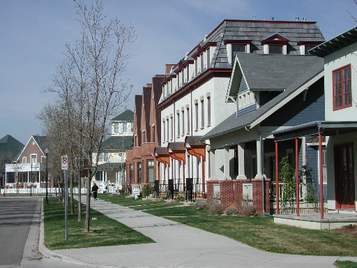
MUDS 4.1.5 The General Sub-Zone.
The General Sub-Zone has a denser and primarily residential urban fabric; mixed-use buildings are usually confined to certain corner locations. This sub-zone has a wide range of building types: single family detached houses, townhouses, apartment buildings, and more. Setbacks and street tree plantings are more variable. Streets typically define medium-sized blocks.
|
|
MUDS 4.1.6 The Edge Sub-Zone.
The Edge Sub-Zone is similar in density to conventional residential areas but differs by its superior connectivity. This sub-zone is more naturalistic in planting. Blocks may be large and more irregular to accommodate site conditions.
|
|
.jpg)
MUDS 4.1.7 The Civic Sub-Zone.
The Civic Sub-Zone consists of sites reserved for Civic Buildings and open space. This sub-zone includes land reserved for parks, greens, squares, plazas, pedestrian paths, and civic buildings.
|
|
.jpg)
Effective on: 1/1/1901
MUDS 4.2 Allowed & Required Sub-Zones
| Development Types | ||
|---|---|---|
| Mixed-Use Corridor Development | Mixed-Use Center | Mixed-Use Neighborhood |
MUDS 4.2.1 Intent.
Due to their different scales, each mixed-use development type should be required to have a different minimum number of sub-zones. Size and location should also determine the suitability for use of a sub-zone within a mixed-use development type.
Standard:
MUDS 4.2.2 Minimum Number of Sub-Zones.
To ensure a variety of building types and housing choices in close proximity to each other, each mixed-use development is required to include a minimum number of sub-zones according the following table.
| Mixed-Use Development Type | Minimum Number of Sub-Zones Required |
|---|---|
| Mixed-Use Neighborhood | 4 |
| Mixed-Use Center | 3 |
| Mixed-Use Corridor Development | 1 |
MUDS 4.2.3 Allowed, Required, and Prohibited Sub-Zones.
Due to their different development scales and locations, not all mixed-use development types are permitted to contain every sub-zone. Sub-zones are allowed in mixed-use development types according to the following table.
| Applicability of the Sub-Zone in a: | |||||||||||
|---|---|---|---|---|---|---|---|---|---|---|---|
| Mixed-Use Sub-Zone | Mixed-Use Neighborhood | Mixed-Use Center | Mixed-Use Corridor Development | ||||||||
| Core | |||||||||||
| Center | Required | ||||||||||
| General | |||||||||||
| Edge | |||||||||||
| Civic | Required | Required | |||||||||
|
|||||||||||
Effective on: 1/1/1901
MUDS 4.3 Regulating Plan
| Development Types | ||
|---|---|---|
| Mixed-Use Corridor Development | Mixed-Use Center | Mixed-Use Neighborhood |
MUDS 4.3.1 Intent.
A mixed-use development should not be zoned simply as a mixed-use district; it should be zoned based on the location of its core, center, general, edge, and/or civic sub-zones. Doing so ensures that the public and governing bodies can adequately evaluate a development’s anticipated character and scale.
MUDS 4.3.2 Standard.
As part of the development application, a plan shall be submitted that shows the disposition of sub-zones contained in the development. This plan shall be the regulating plan. The regulating plan shall be sub-zone specific to both the block and the lot.
| Mixed-Use Neighborhood Regulating Plan Example | |
|---|---|
.jpg) |
|
| Development Specifications | |
| Minimum Number of Sub-Zones Required for a Mixed-Use Neighborhood | 4 |
| Number of Sub-Zones Included in this Plan | 4 |
| Mixed-Use Center Regulating Plan Example | |
|---|---|
.jpg) |
|
| Development Specifications | |
| Minimum Number of Sub-Zones Required for a Mixed-Use Center | 3 |
| Number of Sub-Zones Included in this Plan | 3 |
| Mixed-Use Corridor Development Regulating Plan Example | |
|---|---|
.jpg) |
|
| Development Specifications | |
| Minimum Number of Sub-Zones Required for a Mixed-Use Corridor Development | 1 |
| Number of Sub-Zones Included in this Plan | 3 |
Effective on: 1/1/1901
MUDS 4.4 Allowed Building Types
| Development Types | ||
|---|---|---|
| Mixed-Use Corridor Development | Mixed-Use Center | Mixed-Use Neighborhood |
MUDS 4.4.1 Intent.
While all types of buildings may occur within a short walking distance of each other in a mixed-use development, some building types are not naturally compatible enough in scale and character to be located next each other. A mixed-use district should provide sub-zones composed of compatible building types.
Standard:
MUDS 4.4.2 Building Types.
In an MXD, a variety of building types are permitted. Each building within an MXD shall be classified as a building type and shall adhere to all standards applicable to that building type.
MUDS 4.4.3 Allowed Building Types by Sub-Zone.
Each sub-zone in an MXD contains a different mixture of building types; not every building type is allowed in every sub-area. Building type is regulated by sub-zone according to the following table.
| Allowed Building Types |
|---|
.jpg) |
| Applicability of the Building Type in Sub-Zone: | ||||||||||||||
|---|---|---|---|---|---|---|---|---|---|---|---|---|---|---|
| Building Type | Core | Center | General | Edge | Civic | |||||||||
| I | Mixed-Use Building | C | ||||||||||||
| II | Live/Work Building | C | ||||||||||||
| III | Civic Building | |||||||||||||
| IV | Commercial Building | C | ||||||||||||
| V | Apartment Building | |||||||||||||
| VI | Townhouse | |||||||||||||
| VII | Flat Over Flat (Duplex) | |||||||||||||
| VIII | Paired House (Duplex) | |||||||||||||
| IX | Single Family Detached House | |||||||||||||
| X | Accessory Unit | |||||||||||||
|
||||||||||||||
MUDS 4.4.4 Type I. Mixed-Use Building.
Mixed-Use Building is a structure with a vertical mixture of uses. The upper floors may be used for office, residential, lodging, storage, or parking; the ground floor (lot frontage at the street level) may be used for retail or office.
| Allowed Building Types |
|---|
|
|
.jpg)
MUDS 4.4.5 Type II. Live/Work Building.
Type II. Live/Work Building is a dwelling unit that contains, to a limited extent, a retail or office component. A live/work building is a fee-simple unit on its own lot with the commercial component limited to the ground level.
| Allowed Building Types |
|---|
|
|
.jpg)
MUDS 4.4.6 Type III. Civic Building.
Type III. Civic Building is a structure specifically designed for a civic function. Buildings and structures for public or private assembly, including places of worship and schools, shall be considered civic buildings.
| Allowed Building Types |
|---|
|
|
.jpg)
MUDS 4.4.7 Type IV. Commercial Building.
Type IV. Commercial Building is a single-use, one-story structure with either office or retail use.
| Allowed Building Types |
|---|
|
|
.jpg)
MUDS 4.4.8 Type V. Apartment Building.
Type V. Apartment Building is a structure with more than two dwelling units on one lot. The apartment building type may also be used for lodging purposes.
| Allowed Building Types |
|---|
|
|
.jpg)
MUDS 4.4.9 Type VI. Townhouse.
Type VI. Townhouse is a dwelling unit attached by a common wall to at least one other dwelling unit. A townhouse is generally a fee-simple unit, from ground to roof, with no units above or below. Structures containing townhouses must contain at least three townhouses.
| Allowed Building Types |
|---|
|
|
.jpg)
MUDS 4.4.10 Type VII. Flat-over-Flat (Duplex).
Type VII. Flat-over-Flat (Duplex) is a structure with two dwelling units placed one above the other.
| Allowed Building Types |
|---|
|
|
.jpg)
MUDS 4.4.11 Type VIII. Paired House (Duplex).
Type VIII. Paired House (Duplex) is a structure with two dwelling units placed one beside the other sharing a common wall.
| Allowed Building Types |
|---|
|
|
.jpg)
MUDS 4.4.12 Type IX. Single Family Detached House.
Type IX. Single Family Detached House is one dwelling unit on its own lot, detached from structures on adjoining lots. An accessory unit may be located on the same lot as a single family detached house; the accessory unit may be attached or detached to the single family detached house.
| Allowed Building Types |
|---|
|
|
.jpg)
MUDS 4.4.13 Type X. Accessory Unit.
Type X. Accessory Unit is a dwelling unit that is located over a garage on the same lot as the main structure. An accessory unit may also be a single-story dwelling unit, not associated with a garage, located on the same lot as the main structure. An accessory unit may be attached or detached from the main structure and is located to the rear of the lot.
| Allowed Building Types |
|---|
|
|
.jpg)
Effective on: 1/1/1901
MUDS 4.5 Required Design Elements
| Development Types | ||
|---|---|---|
| Mixed-Use Corridor Development | Mixed-Use Center | Mixed-Use Neighborhood |
MUDS 4.5.1 Intent.
Mixed-use developments typically exhibit a similar design quality. Aside from specific regulations contained in this document, a mixed-use district should exhibit design elements that are consistent with historically successful mixed-use developments.
MUDS 4.5.2 Standard.
Each mixed-use development type requires specific design elements that must be included to ensure the characteristics of a mixed-use development. These design elements are required according to the following table.
|
Design Element is Required in a: |
||||
|
Design Element |
Mixed-Use |
Mixed-Use |
Mixed-Use |
|
| Element Number | Element Description | |||
|
1 |
The development has streets laid out in a connected network, so there are multiple alternate routes to various destinations |
|||
|
2 |
Street designs accommodate parking. Parking lots and garages rarely front the streets, and are typically relegated to the rear of the lot and the center of blocks. |
|||
|
3 |
All public streets, private access-ways, and roadways, excluding thoroughfares, within the development are designed for relatively slow speeds. |
|||
|
4 |
Buildings are placed close to the street, so that streets and squares feel enclosed. |
|||
|
5 |
Each development shall have public amenities such as gathering places, public areas, and/or common spaces. |
|||
|
6 |
Each development has at least one discernible center. |
Not |
||
|
7 |
Sub-zones within the development are in succession (Edge, General, Center, etc.), but may skip one zone. In no case may the sub-zones skip over more than one sub-zone (example: Edge to Core). The Civic sub-zone does not occur in succession and may abut any other zone. |
|||
|
8 |
Each development has a variety of dwelling types. |
|||
|
9 |
The plan consists of a series of neighborhoods based on pedestrian sheds. This encourages walking and interaction among residents. A pedestrian shed is the area encompassing a 1/4 mile radius out from a discernible center; 1/4 mile correlates to a 5 minute walk. |
Not |
||
|
10 |
All developments of 80 acres shall provide at least one civic building in the development. |
|||
|
11 |
Each development has a variety of open spaces. |
|||
Effective on: 1/1/1901
MUDS 4.6 Permitted Uses & Intensity of Use
| Development Types | ||
|---|---|---|
| Mixed-Use Corridor Development | Mixed-Use Center | Mixed-Use Neighborhood |
MUDS 4.6.1 Intent.
To ensure compatible scales and uses within a sub-zone, mixed-use developments should limit the intensity of uses within certain sub-zones.
Standard:
MUDS 4.6.2 Permitted Office & Retail Uses.
Office and retail uses in an MXD shall conform to the uses specified for zoning district CP-2 (UDO 18.270.020).
MUDS 4.6.3 Intensity of Use.
Intensity of use is governed by sub-zone, lot location, and parking requirements according to the following table.
|
Allowed Intensity of the Use in this Sub-Zone: |
||||
|---|---|---|---|---|
|
Use |
Core |
Center |
General |
Edge |
|
Retail |
No Applicable Standard |
Building area available for retail use is restricted to the first story of block corner locations |
N/A |
|
|
Office |
No Applicable Standard |
Building area available for office use is restricted to the first story of block corner locations |
N/A |
|
|
Residential: building types |
No Applicable Standard |
Minimum of three allowed building types, excluding accessory units, must be constructed; each building type in the general sub-zone must account for at least 10% of the total number of units within the sub-zone |
N/A |
|
|
Residential: accessory units |
No Applicable Standard |
Maximum of one accessory unit per main structure; Accessory unit square footage shall not exceed 50% of the main structure’s furnished space, excluding garages and basements. |
||
|
Lodging |
No Applicable Standard |
Maximum of 12 bedrooms for lodging allowed on each lot |
N/A |
|
|
All Uses |
No Applicable Standard |
Use limited by the parking standards |
||
Effective on: 1/1/1901
MUDS 4.7 Project Design Manual
| Development Types | ||
|---|---|---|
| Mixed-Use Corridor Development | Mixed-Use Center | Mixed-Use Neighborhood |
MUDS 4.7.1 Intent.
The public and governing bodies should be provided with enough information to understand the scope, scale, and design qualities of a development at the time of rezoning or development approval. Therefore, an application for mixed-use development should both convey the project’s vision and illustrate how the project meets the standards required by this document.
MUDS 4.7.2 Standard.
In an MXD, a wide variety of uses and structures are permitted. To encourage this, the city requires any applicant seeking this zoning classification or developing within this zoning district to submit, as a part of the application, a Project Design Manual. The Project Design Manual shall include, but shall not be limited to, the items listed in the following table.
|
Project Design Manual shall include, but shall not be limited to, the following: |
Required in this Mixed-Use Development Type: |
|||
|
Mixed-Use |
Mixed-Use |
Mixed-Use |
||
|
1 |
A detailed summary of the project including the scope and vision of the project |
|||
|
2 |
A detailed analysis of the existing and surrounding zoning |
|||
|
3 |
Regulating plan |
|||
|
4 |
Illustrations of the building types contained in the project & their anticipated locations |
|||
|
5 |
Illustrated thoroughfare standards |
|||
|
6 |
Preliminary landscape plan, landscape standards, and street tree schedule |
|||
|
7 |
Architectural standards for the project |
|||
|
8 |
Phasing diagram |
|||
|
9 |
Unit count |
|||
|
10 |
Illustrations of preliminary grading |
|||
|
11 |
Illustrations of the stormwater management plan, including flood plain, stream corridor, flood control detention facilities, stormwater treatment facilities |
|||
|
12 |
Utility location strategy for the development; the strategy shall include coordination of general utility locations with utility providers |
|||
|
13 |
IIllustrative plan of the development |
|||
|
14 |
Illustrations of parks, open space, block patterns, and street network |
Not Required |
||
|
15 |
Illustrations of pedestrian shed(s) |
Not Required |
||
Effective on: 1/1/1901
MUDS 5.1 Block Size
| Development Types | ||
|---|---|---|
| Mixed-Use Corridor Development | Mixed-Use Center | Mixed-Use Neighborhood |
MUDS 5.1.1 Intent.
To promote walkability and street connectivity, streets and private access-ways should be designed with small block sizes and minimal distances between intersections. Although dimensions vary even within a single development, mixed-use developments typically have block perimeters of about 1/4 mile.
Standard:
MUDS 5.1.2 Block Size.
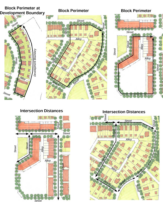
Block size shall be regulated by block perimeter and intersection distance according to the following table.
|
Sub-Zone |
Maximum |
Maximum |
|---|---|---|
|
Core |
2000’ |
500’ |
|
Center |
||
|
General |
2000’ |
700’ |
|
Edge |
3000’ |
700’ |
MUDS 5.1.3 Intersection Distance.
Intersection distance shall be the distance between two consecutive street and/or private access way intersections; intersection distance shall be measured between the centerlines. Alleys and driveways shall not be considered streets or private access-ways for the purposes of this standard.
MUDS 5.1.4 Block Perimeter.
Block perimeter shall be the perimeter distance of a block; block perimeter shall be measured at the lot line around blocks. For blocks that abut a boundary to the mixed-use development, the boundary line shall be considered an edge to the block.
 |
Effective on: 1/1/1901
MUDS 5.2 Lot Size
| Development Types | ||
|---|---|---|
| Mixed-Use Corridor Development | Mixed-Use Center | Mixed-Use Neighborhood |
MUDS 5.2.1 Intent.
To ensure flexibility and promote variety, minimum and maximum lot sizes should be specified by sub-zone.
Standard:
MUDS 5.2.2 Lot Size.
Lot size shall be regulated according to the following table. Lot width shall be measured at the lot line.
| Sub-Zone | Permitted Lot Width along Primary Frontage |
|
|---|---|---|
| Core | No Restrictions | |
| Center | 100’ max. | |
| General | Attached Structures | 16’ min. |
| Detached Structures | 25’ min. | |
| Edge | 25-50% of the total number of Edge Lots | not less than 25’; not greater than 45’ |
| 25-50% of the total number of Edge Lots | greater than 45’; not greater than 60’ |
|
| 15-35% of the total number of Edge Lots | greater than 60’ | |
| Lot Width Measurement |
|---|
.jpg) |
| Example Lot Widths |
|---|
.jpg) |
Effective on: 1/1/1901
MUDS 5.3 Building Envelopes
| Development Types | ||
|---|---|---|
| Mixed-Use Corridor Development | Mixed-Use Center | Mixed-Use Neighborhood |
MUDS 5.3.1 Intent.
To ensure a compatible and consistent streetscape, a mixed-use development should specify where a building must be located on a lot.
MUDS 5.3.2 Standard.
Possible building envelopes are regulated by sub-zone and building type and are measured from the property line according to the following table. In existing neighborhoods, building setbacks shall align with existing adjacent structures for all building types except mixed-use building, live/work building, and small commercial building.
|
Corner Lots |
.jpg) |
Comment. Inclusion of a specific building type in this table shall not imply its applicability in a sub-zone; permitted building types for each sub-zone are listed in the Allowed Building Types standard.
| Building Type (see comment) | Sub-Zone | |
| Core & Center | ||
| Corner Lots | Interior Lots | |
|
I. Mixed-Use Building |
.jpg)
Notes 1 & 2 apply |
.jpg)
Note 1 applies |
|
II. Live/Work Building |
||
| IV. Commercial Building | ||
| III. Civic Building | .jpg)
Notes 1 & 2 apply |
.jpg)
Note 1 applies |
| V. Apartment Building | ||
| VI. Townhouse | ||
| VII. Flat Over Flat (Duplex) | ||
| VIII. Paired House (Duplex) | ||
| IX. Single Family Detached House | ||
| X. Accessory Unit | ||
|
||
Comment. Inclusion of a specific building type in this table shall not imply its applicability in a sub-zone; permitted building types for each sub-zone are listed in the Allowed Building Types standard.
| Building Type (see comment) | Sub-Zone | |
| General | Edge | |
| Corner & Interior lots | Corner & Interior lots | |
| I. Mixed-Use Building | .jpg) |
Not Applicable |
| II. Live/Work Building | ||
| IV. Commercial Building | ||
| III. Civic Building | .jpg) |
.jpg) |
| V. Apartment Building | ||
| VI. Townhouse | ||
| VII. Flat Over Flat (Duplex) | ||
| VIII. Paired House (Duplex) | ||
| IX. Single Family Detached House | ||
| X. Accessory Unit | ||
Effective on: 1/1/1901
MUDS 5.4 Building Height
| Development Types | ||
|---|---|---|
| Mixed-Use Corridor Development | Mixed-Use Center | Mixed-Use Neighborhood |
MUDS 5.4.1 Intent.
To ensure a compatibility of building types within a sub-zone, a mixed-use development should specify acceptable building heights.
MUDS 5.4.2 Standard.
The height of the primary building on a lot is regulated by zone and building type. Building height in stories shall be measured as viewed from the primary street frontage of the building. Walk-out basements not located on the primary street frontage shall not be considered a story.
Comment. Inclusion of a specific building type in this table shall not imply its applicability in a sub-zone; permitted building types for each sub-zone are listed in the Allowed Building Types standard.
| Building Type (see comment) | Sub-Zone | |
|---|---|---|
| Core | Center | |
| I. Mixed-Use Building | .jpg) |
|
| II. Live/Work Building | ||
| IV. Commercial Building | Not Applicable | .jpg) |
| III. Civic Building |
|
|
| V. Apartment Building | ||
| VI. Townhouse | ||
| VII. Flat Over Flat (Duplex) | ||
| VIII. Paired House (Duplex) | ||
| IX. Single Family Detached House | ||
| X. Accessory Unit | .jpg) |
|
.jpg)
.jpg)
.jpg)
Comment. Inclusion of a specific building type in this table shall not imply its applicability in a sub-zone; permitted building types for each sub-zone are listed in the Allowed Building Types standard.
| Building Type (see comment) | Sub-Zone | |
|---|---|---|
| General | Edge | |
| I. Mixed-Use Building | .jpg) |
Not Applicable |
| II. Live/Work Building | ||
| IV. Commercial Building | .jpg) |
Not Applicable |
| III. Civic Building |
|
|
| V. Apartment Building | ||
| VI. Townhouse | ||
| VII. Flat Over Flat (Duplex) | ||
| VIII. Paired House (Duplex) | ||
| IX. Single Family Detached House | ||
| X. Accessory Unit | .jpg) |
|
.jpg)
.jpg)
Effective on: 1/1/1901
MUDS 6.1 Existing Trees & Vegetation
| Development Types | ||
|---|---|---|
| Mixed-Use Corridor Development | Mixed-Use Center | Mixed-Use Neighborhood |
MUDS 6.1.1 Intent.
Significant existing trees and vegetation should be incorporated into the design of the development as natural features. Appropriate locations to preserve existing trees and vegetation include streamways, drainageways, steep slopes, and any other area where a natural woodland, grassland, or wetland is desired as an amenity to the development or the city.
Standard:
MUDS 6.1.2 Significant Trees.
Significant trees in design-appropriate locations shall be preserved or transplanted on site. Significant tree shall be defined as one of the following:
- Deciduous tree with a twelve inch (12”) minimum caliper
- Evergreen tree at least twelve feet (12’) in height
- Groups of ten (10) or more deciduous or evergreen trees with a six inch (6”) minimum caliper
MUDS 6.1.3 Tree Survey.
Developers shall submit an existing tree survey and preservation plan. The extent of the survey required shall be determined by the city.
MUDS 6.1.4 Preserved Trees and Vegetation.
All preserved trees and vegetation shall be healthy and free of mechanical injury. Significant trees shall be protected during construction with the erection of barrier fencing. Grading shall be avoided within the root area or drip line of any preserved trees.
MUDS 6.1.5 Tree Replacement.
If a significant tree designated to be preserved is removed or substantially damaged during clearing, grading, or construction, the developer shall replace the removed or damaged tree with new trees. Replacement trees shall be the same or similar species to the trees removed or damaged, or a species native to Johnson County and approved by the city. For every one inch (1”) of combined total tree caliper removed or damaged, the applicant or developer shall do one of the following:
- Replace two (2) inches of combined total tree caliper; if this option is prohibited by site conditions, the applicant shall work with the City Forester to develop a tree replacement plan.
- With the city’s concurrence, contribute an equivalent sum to the city’s tree replacement fund.
Effective on: 1/1/1901
MUDS 6.2 Street Trees: Species & Standards
| Development Types | ||
|---|---|---|
| Mixed-Use Corridor Development | Mixed-Use Center | Mixed-Use Neighborhood |
MUDS 6.2.1 Intent.
The consistent use of street trees is a typical design feature for mixed-use developments. Street trees should be planted and spaced to provide both a continuous, shaded sidewalk and a spatially-enclosed street.
Standard:
MUDS 6.2.2 Street Trees.
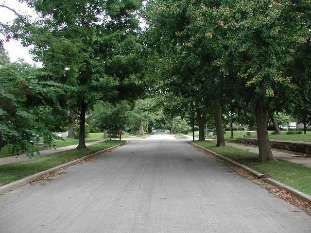
Street trees are required along all streets and roadways. Street trees shall provide both a continuous, shaded environment along roadways and a physical and visual barrier between a pedestrian on the sidewalk and vehicles on the roadway. Alleys and service drives shall not be considered streets or roadways for the purposes of this standard.
MUDS 6.2.3 Standards and Species.
Street trees shall conform to the standards provided in the following table.
| Street Trees | |
|---|---|
 |
|
| Street Tree Standards | |
| Species |
|
| Size |
|
| Spacing |
|
| Configuration |
|
| Location |
|
Effective on: 1/1/1901
MUDS 6.3 Street Trees: Planting Conditions
| Development Types | ||
|---|---|---|
| Mixed-Use Corridor Development | Mixed-Use Center | Mixed-Use Neighborhood |
MUDS 6.3.1 Intent.
Street trees should be planted in environments and conditions that promote their successful growth and ensure adequate pedestrian access.
Standard:
MUDS 6.3.2 Allowed Planting Conditions.
Street trees shall be planted in tree wells, tree planters, or tree lawns. Tree wells, tree planters, and tree lawns are applicable in sub-zones according the following table.
| Sub-Zone | Street Tree Planting Condition | ||
| Tree Lawn | Tree Planter | Tree Well | |
| Core | Prohibited | Allowed | |
| Center | |||
| General | Allowed | ||
| Edge | Allowed | Prohibited | |
MUDS 6.3.3 Size and Area.
The size and area for the planting condition shall conform to the following table.
| Street Tree Planting Condition |
Street Tree Planting Condition Size & Area | |||
| Width | Length | Planting Area per Tree | ||
| Tree Well | 5’ min. | 5’ min. | 25 s.f. min. | 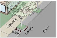 |
| Tree Planter | 5' min. | 10’ min. | 25 s.f. min. | 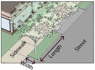 |
| Tree Lawn | 6' min. | no min. | no min. | 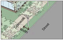 |
MUDS 6.3.4 Street Trees.
Street trees in an MXD shall be trees planted along streets and roadways.
|
|
.jpg)
MUDS 6.3.5 Tree Lawn.
A tree lawn is a continuous landscaped strip between the edge of a street and a detached sidewalk.
|
|
.jpg)
MUDS 6.3.6 Tree Well.
A tree well is an individual landscaped area surrounded by pavement.
|
|
.jpg)
MUDS 6.3.7 Tree Planter.
A tree planter is an individual landscaped area larger than a tree well that is surrounded by pavement and may be elevated above the level of the surrounding pavement with curbs or planter walls. The entire area of the tree planter shall be planted with turfgrass or shall be mulched and planted with groundcover.
|
|
.jpg)
Effective on: 1/1/1901
MUDS 7.1 Parking Requirements
| Development Types | ||
|---|---|---|
| Mixed-Use Corridor Development | Mixed-Use Center | Mixed-Use Neighborhood |
MUDS 7.1.1 Intent.
To avoid excessive parking areas, standards for mixed-use developments should encourage low parking minimums and allow developments that combine different uses on the same block to reduce those required minimums.
Standard:
MUDS 7.1.2 Required Parking Spaces.
Parking Standards are regulated by sub-zone. For all uses, required parking spaces shall be located off-street, on-street, or a combination of off-street and on-street. On-street parking spaces may be counted towards the minimum requirements, subject to good traffic engineering design principles, provided the on-street spaces are located adjacent to the site. On-street parking spaces being counted towards the required parking must be identified on plans at time of submittal to the City. Projects providing parking outside of the ranges below must provide Demand Reduction Amenities (see UDO 18.430.170). Parking shall conform to the following table.
| Required Parking Spaces | |||||
| For this Use: | The required number of parking spaces in this sub-zone shall be : |
||||
| Core | Center | General | Edge | Civic | |
| Residential | No minimum and a maximum of 2 spaces per dwelling unit | A minimum of 1 space per unit and a maximum of 2.5 spaces per unit | A minimum of 1 space per unit and a maximum of 2.5 spaces per unit | No minimum | |
| Lodging | No minimum | 1 space per lodging bedroom minimum | N/A | No minimum | |
| Office or Retail | No minimum and a maximum of 2.5 spaces per 1,000 square feet | A minimum of 1.5 parking spaces and a maximum of 2.5 parking spaces for each 1,000 square feet of building area | N/A | No minimum | |
MUDS 7.1.3 Reduced Parking.
See 18.430.170 in the UDO.
MUDS 7.1.4 Parking Setback.
No parking area shall be located within 10 feet of any street right-of-way.
MUDS 7.1.5 Nonconforming Parking.
See 18.430.210 in the UDO.
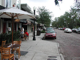
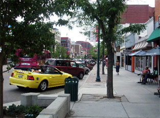
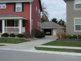
| On-Street Parking Examples | |
|---|---|
|
Parallel Parking |
Angled or Head-in Parking |
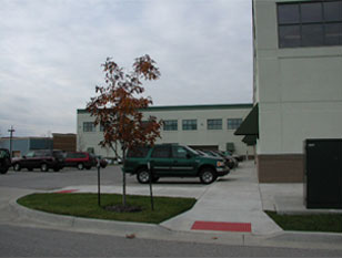
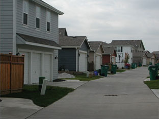
| Off-Street Parking Examples | |
|
Parking Located behind the Building
|
Alley-Loaded Garage |
|
Front-Loaded Garage
|
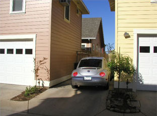
Alley-Accessed Parking Space
|
Effective on: 1/1/1901
MUDS 7.2 Parking Lots & Garages
| Development Types | ||
|---|---|---|
| Mixed-Use Corridor Development | Mixed-Use Center | Mixed-Use Neighborhood |
MUDS 7.2.1 Intent.
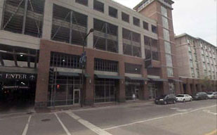
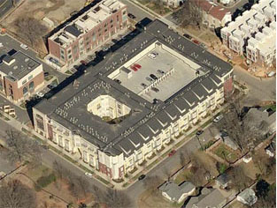
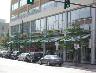
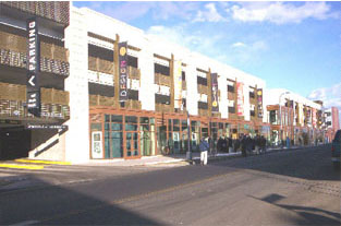
To promote an active and diverse streetscape, parking lots and garages should be located behind buildings in the interior of blocks. Parking garages that front streets should line the parking garage at the street level with an active use.
MUDS 7.2.2 Standard.
Parking lots and parking garages shall be located in the interior of blocks. Parking garages that front onto streets shall provide a lining of retail, office, or residential use at the street level along the entire street frontage. Parking garages that provide this lining of retail, office, or residential use at the street level are classified as mixed-use buildings.
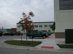
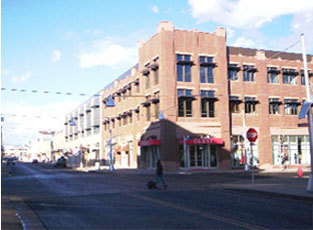
| Parking Lots and Garages located in the interior of Blocks | |
|---|---|
|
The parking lot is correctly located behind the buildings on the interior of the block.
|
This parking garage is located behind the buildings on the interior of the block.
|
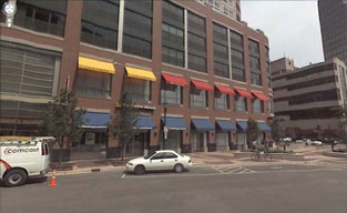
| Parking Garages fronting onto Streets with Liners | |
|---|---|
|
This parking garage is lined with retail and office space on the first two floors along its entire street frontage.
|
The parking garage is lined with retail space along the street frontage.
|
|
This parking garage is fully lined with an apartment building along its street frontages.
|
The parking garage is lined with retail and office space on the first two floors along its entire street frontage.
|
|
The parking garage is lined with display space on the first two floors along its entire street frontage.
|
This parking garage is lined with retail space on the first floor along its entire street frontage.
|
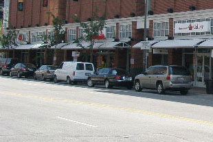
Effective on: 1/1/1901
MUDS 8.1 Definitions
| Development Types | ||
|---|---|---|
| Mixed-Use Corridor Development | Mixed-Use Center | Mixed-Use Neighborhood |
Alley: low capacity roadway along the rear of properties providing common access for parking, service areas, accessory units, and utility easements. An alley shall be privately owned.
Effective on: 1/1/1901
Block: the aggregate of private lots, passages, rear lanes, and alleys, circumscribed by streets and roadways.
Effective on: 1/1/1901
Civic: the term defining not-for-profit organizations dedicated to arts, culture, education, recreation, government, transit, religion, and municipal parking.
Effective on: 1/1/1901
Civic Space: an open area dedicated for public use.
Effective on: 1/1/1901
Design Manual: a manual used as a tool for the applicant to present their vision for the MXD development. The design manual is accepted as the plan for the development and is used as a guide for plan review.
Effective on: 1/1/1901
Fee-Simple: the private ownership of property (real estate) in which the owner has the right to control, use, and transfer the property at will.
Effective on: 1/1/1901
Frontage Line: the front property line and/or right-of-way line of a building lot.
Effective on: 1/1/1901
Lodging: premises available for daily and/or weekly renting of bedrooms.
Effective on: 1/1/1901
Open Space: an area or tract of land that is set aside and left natural or is manicured for the enjoyment of the public. These areas should be accessible both physically and visually to residences of the community. Such land shall be owned and maintained by a government, the developer, the owner, or the property owners association.
Effective on: 1/1/1901
Outdoor Room: an open space that is framed by buildings, fences, walls, or landscaping in order to create the feel of a private open space.
Effective on: 1/1/1901
Pedestrian Shed: an area defined by the average distance that may be traversed at an easy walking pace from its edge to its center. This distance is applied to determine the size of a neighborhood or extent of a community. A standard pedestrian Shed is one quarter of a mile radius, or 1,320 feet. Pedestrian sheds should be conceived as oriented toward a central destination containing one or more important intersections, meeting places, civic spaces, civic buildings, and the capacity to accommodate a center or core sub-zone in the future.
Effective on: 1/1/1901
Sub-Zone: a geographical cross-section, used to identify the level of urban character and intensity of a mixed-use district (MXD) development.
Effective on: 1/1/1901
Use-Segregated Development: a method of development wherein different types of uses are separated and sorted by type, size, and setback from property lines.
Effective on: 1/1/1901
Walkable Neighborhoods: neighborhoods that are designed to allow residents the ability and reason to walk around the neighborhood for goods, services, and social interaction.
Effective on: 1/1/1901
MUDS 9.1 Mixed-Use Street Type Precedents
| Development Types | ||
|---|---|---|
| Mixed-Use Corridor Development | Mixed-Use Center | Mixed-Use Neighborhood |
MUDS 9.1.1 Intent.
Mixed-use districts should use designs for streets, drives, and access-ways that have historically supported mixed-use neighborhoods and communities. The intent of the mixed-use street types is to give examples of streets that could be suitable for mixed-use districts in Overland Park, Kansas.
MUDS 9.1.2 Guideline.
The street types in this guideline exhibit the design qualities that are compatible with a mixed-use district; an application for a mixed-use district should use these precedents as a guide for developing specific street types for the application. This listing covers a simple cross section of street types that generally would be suitable for a different range of sub-zones within a mixed-use district; this list, however, does not qualify as a complete list of the type of streets that could be applicable in a mixed-use district.
MUDS 9.1.3 Thoroughfares.
These street types shall not apply to any thoroughfares adjoining or bisecting a mixed-use district.
MUDS 9.1.4 Street Type Submittal.
Applications for a mixed-use district shall include dimensional standards for its streets, drives, and access-ways and shall indicate their location on a plan of the development.
MUDS 9.1.5 Approval Required.
Inclusion of these street types does not imply, explicitly or implicitly, their approval for use in a mixed-use district by the city; applicants shall receive approval in order to construct any street, drive, or access-way that does not meet currently adopted standards. All street types shall be approved by the City Engineer.
MUDS 9.1.6 Applicable Sub-Zones.
Most street types within a mixed-use district will not be suitable for every sub-zone; specific street types in a development should be designed for use in specified sub-zones. The street types given in this section have been classified for their applicability in sub-zones according to the table below.
|
Applicable Sub-Zones |
|||||
|---|---|---|---|---|---|
|
Section |
Street |
Core |
Center |
General |
Edge |
| MUDS 9.1.7 |
Avenue |
||||
| MUDS 9.1.8 |
Commercial Street |
||||
| MUDS 9.1.9 |
Residential Street |
||||
| MUDS 9.1.10 |
Parkway |
||||
| MUDS 9.1.11 |
Drive with Angled Parking |
||||
| MUDS 9.1.12 |
Drive with Parallel Parking |
||||
| MUDS 9.1.13 |
Lane |
||||
| MUDS 9.1.14 |
Two-Lane Alley |
||||
| MUDS 9.1.15 |
Yield Alley |
||||
MUDS 9.1.7 Avenue.
The Avenue is a street type that would be compatible for use in a Core or Center Sub-Zone of an MXD. Its primary use would be for a “main street” that has mixed-use, live/work, or small commercial building fronts. Two-way traffic is accommodated with two travel lanes. Convenience parking is provided with angled on-street parking; additional parking could be provided in parking lots or parking structures located on the interior of the blocks behind the building fronts.
| Avenue | |
|---|---|
.jpg) |
|
|
Design Speed |
25 mph |
|
Posted Speed |
20 mph |
|
Applicable Mixed-Use Sub-Zones |
Core; Center |
|
R.O.W. |
86’ - 90’ |
|
Roadway Width |
62’ B.O.C. to B.O.C. |
|
Traffic Lanes |
2 lanes; two-way |
|
Traffic Lane Width |
14’ |
|
Parking Lanes |
Angled 45 degrees both sides |
|
Parking Lane Width (includes curb & gutter) |
17’ |
|
Sidewalk Width |
7’ minimum |
|
Street Tree Planting Condition |
Tree Well: 5’ minimum width |
MUDS 9.1.8 Commercial Street.
The Commercial Street is a street type that would be compatible for use in a Core or Center Sub-Zone of an MXD; this type of street could be the predominate street type in Core and Center Sub-Zones. Its primary use would be for a street that has mixed-use, live/work, small commercial, or apartment building fronts. Two way traffic is accommodated with two travel lanes. Convenience parking is provided with parallel on-street parking; additional parking could be provided in parking lots or parking structures located on the interior of the blocks behind the building fronts.
|
Commercial Street |
|
|---|---|
.jpg) |
|
|
Design Speed |
25 mph |
|
Posted Speed |
20 mph |
|
Applicable Mixed-Use Sub-Zones |
Core; Center |
|
R.O.W. |
60’ minimum |
|
Roadway Width |
36’ - 40’ B.O.C. to B.O.C. |
|
Traffic Lanes |
2 lanes; two-way |
|
Traffic Lane Width |
10’ - 12’ |
|
Parking Lanes |
Parallel both sides |
|
Parking Lane Width (includes curb & gutter) |
8’ |
|
Sidewalk Width |
7’ minimum |
|
Street Tree Planting Condition |
Tree Well: 5’ minimum width |
MUDS 9.1.9 Residential Street:
The Residential Street is a street type that would be compatible for use in a Center or General Sub-Zone of an MXD. This type of street could be the predominate street type in General Sub-Zones; its use in the Edge Sub-Zone should be limited to streets with substantial through-traffic. Its primary use could be for a street that has apartment, townhouse, and duplex building fronts. Two way traffic is accommodated with two travel lanes. On-street parking is provided by parallel parking on both sides of the street.
|
Residential Street |
|
|---|---|
.jpg) |
|
|
Design Speed |
30-35 mph |
|
Posted Speed |
25-30 mph |
|
Applicable Mixed-Use Sub-Zones |
Center; General |
|
R.O.W. |
60’ minimum |
|
Roadway Width |
36’ - 40’ B.O.C. to B.O.C. |
|
Traffic Lanes |
2 lanes; two-way |
|
Traffic Lane Width |
10’ - 12’ |
|
Parking Lanes |
Parallel both sides |
|
Parking Lane Width (includes curb & gutter) |
8’ |
|
Sidewalk Width |
5’ minimum |
|
Street Tree Planting Condition |
Tree Well: 5’ minimum width |
MUDS 9.1.10 Parkway.
The Parkway is a street type that would be compatible for use in a Core, Center, General, or Edge Sub-Zone of an MXD. Its primary characteristic is that one side of the street contains a Civic Sub-Zone; a variety of building types could front the other side of the street;. Two way traffic is accommodated with two travel lanes. On-street parking is provided by parallel parking on the building side of the street. In situations where higher traffic volumes are anticipated, the 28 feet wide roadway should be used.
|
Parkway |
|
|---|---|
.jpg) |
|
|
Design Speed |
30 mph |
|
Posted Speed |
25 mph |
|
Applicable Mixed-Use Sub-Zones |
Core; Center; General; Edge |
|
R.O.W. |
37’ minimum |
|
Roadway Width |
24’ - 28’ B.O.C. to B.O.C. |
|
Traffic Lanes |
2 lanes; two-way |
|
Traffic Lane Width |
8’ - 10’ |
|
Parking Lanes |
Parallel one side |
|
Parking Lane Width (includes curb & gutter) |
8’ |
|
Sidewalk Width |
5’ minimum |
|
Street Tree Planting Condition |
Tree Well: 5’ minimum width |
MUDS 9.1.11 Drive with Angled Parking.
The Drive with Angled Parking is a street type that would be compatible for use in a Core or Center Sub-Zone of an MXD. Its primary characteristic is that one side of the street contains a Civic Sub-Zone; a variety of building types could front the other side of the street. One-way traffic is accommodated by one travel lane. On-street parking is provided by angled parking on the building side of the street.
|
Drive with Angled Parking |
|
|---|---|
.jpg) |
|
|
Design Speed |
25 mph |
|
Posted Speed |
20 mph |
|
Applicable Mixed-Use Sub-Zones |
Core; Center |
|
R.O.W. |
44’ minimum |
|
Roadway Width |
31’ B.O.C. to B.O.C. |
|
Traffic Lanes |
1 lane; one-way |
|
Traffic Lane Width |
14’ |
|
Parking Lanes |
Angled 45 degrees on building side of street |
|
Parking Lane Width (includes curb & gutter) |
17’ |
|
Sidewalk Width |
7’ minimum |
|
Street Tree Planting Condition |
Tree Well: 5’ minimum width |
MUDS 9.1.12 Drive with Parallel Parking:
The Drive with Parallel Parking is a street type that would be compatible for use in a Core, Center, General, or Edge Sub-Zone of an MXD. Its primary characteristic is that one side of the street contains a Civic Sub-Zone; a variety of building types could front the other side of the street;. One-way traffic is accommodated by one travel lane. On-street parking is provided by parallel parking on the building side of the street.
|
Drive with Parallel Parking |
|
.jpg) |
|
|
Design Speed |
30 mph |
|
Posted Speed |
25 mph |
|
Applicable Mixed-Use Sub-Zones |
Core; Center; General; Edge |
|
R.O.W. |
33’ minimum |
|
Roadway Width |
20’ - 21’ B.O.C. to B.O.C. |
|
Traffic Lanes |
1 lane; one-way |
|
Traffic Lane Width |
12’ - 13’ |
|
Parking Lanes |
Parallel on building side of street |
|
Parking Lane Width (includes curb & gutter) |
8’ |
|
Sidewalk Width |
5’ minimum |
|
Street Tree Planting Condition |
Tree Well: 5’ minimum width |
MUDS 9.1.13 Lane.
The Lane is a street type that would be compatible for use in a General or Edge Sub-Zone of an MXD; this type of street could be the predominate street type in the Edge Sub-Zone. Its primary use would be for a street that has duplex or single family building fronts. Due to its low traffic volumes and lower parking demands, two-way traffic is accommodated with one travel lane. Parking is provided with parallel on-street parking on both sides of the street.
|
Lane |
|
|---|---|
.jpg) |
|
|
Design Speed |
30 mph |
|
Posted Speed |
25 mph |
|
Applicable Mixed-Use Sub-Zones |
General; Edge |
|
R.O.W. |
52’ minimum |
|
Roadway Width |
28’ B.O.C. to B.O.C. |
|
Traffic Lanes |
1 lane; two-way |
|
Traffic Lane Width |
12’ |
|
Parking Lanes |
Parallel both sides |
|
Parking Lane Width (includes curb & gutter) |
8’ |
|
Sidewalk Width |
5’ minimum |
|
Street Tree Planting Condition |
Tree Well: not applicable Tree Planter: not applicable |
MUDS 9.1.14 Two-Lane Alley.
The Two-Lane Alley is a private street type that would be compatible for use in a Core or Center Sub-Zone of an MXD. Its primary use would be for access to parking, garages, and service areas located at the rear of mixed-use, live/work, commercial, and apartment buildings. No parking is located on the roadway.
|
Two Lane Alley |
|
|---|---|
.jpg) |
|
|
Design Speed |
10 mph |
|
Applicable Mixed-Use Sub-Zones |
Core; Center |
|
R.O.W. or Tract width |
20’ minimum |
|
Roadway Width |
16’ - 22’ Edge-of-pavement to Edge-of-pavement |
|
Traffic Lanes |
2 lanes; two-way |
|
Traffic Lane Width |
8’ - 11’ |
|
Parking Lanes |
Prohibited |
|
Parking Lane Width (includes curb & gutter) |
N/A |
|
Sidewalk Width |
none |
|
Street Tree Planting Condition |
Tree Well: not applicable |
MUDS 9.1.15 Yield Alley.
The Yield Alley is a private street type that would be compatible for use in a General or Edge Sub-Zone of an MXD. Its primary use would be for access to parking and garages located at the rear of apartment, townhouse, duplex, and single-family lots. Due to its extremely low traffic volume, two way traffic is accommodated with one travel lane. No parking is located on the roadway.
|
Yield Alley |
|
|---|---|
.jpg) |
|
|
Design Speed |
10 mph |
|
Applicable Mixed-Use Sub-Zones |
Center; General; Edge |
|
R.O.W. |
20’ minimum |
|
Roadway Width |
15’ Edge-of-pavement to Edge-of-pavement |
|
Traffic Lanes |
1 lane; two-way |
|
Traffic Lane Width |
15’ |
|
Parking Lanes |
Prohibited |
|
Parking Lane Width (includes curb & gutter) |
N/A |
|
Sidewalk Width |
none |
|
Street Tree Planting Condition |
Tree Well: not applicable |
Effective on: 1/1/1901
MUDS 9.2 Pedestrian Realm
| Development Types | ||
|---|---|---|
| Mixed-Use Corridor Development | Mixed-Use Center | Mixed-Use Neighborhood |
MUDS 9.2.1 Intent.
Walkways along building fronts and streets, drives, access-ways, and parking lots should be designed to enhance the pedestrian realm and ensure adequate space for uses provided within the pedestrian realm. The intent of the pedestrian realm standards is to provide direction for the minimal dimensions required to accommodate common items provided within the pedestrian realm.
Standard:
MUDS 9.2.2 Applicability.
An applicant shall use the pedestrian realm standards for developing enhanced pedestrian realms along building fronts and streets, drives, and access-ways.
MUDS 9.2.3 Pedestrian Realm.
The pedestrian realm shall be the area between the curb of a street, drive, access-way, or parking lot and the building facade or property line.
MUDS 9.2.4 Pedestrian Realm Submittal.
Applications shall include dimensional standards for the pedestrian realm included along buildings, streets, drives, and access-ways and shall indicate their location on a plan of the development. This submittal may be fulfilled in the typical sections and plan for street types.
MUDS 9.2.5 Pedestrian Realm Zones.
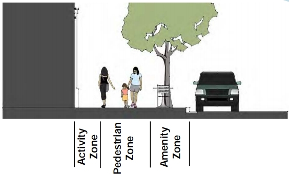
The pedestrian realm is composed of three zones: the activity zone, the pedestrian zone, and the amenity zone.
- Activity Zone. The activity zone shall be the pedestrian realm from the building front to the edge of the pedestrian zone. The activity zone is the section of the pedestrian realm that is reserved for activities that commonly occur immediately adjacent to the building facade. Typical amenities or activities included in the activity zone include, but are not limited to, window shopping, benches, potted plants, dining, and outdoor shopping.
- Pedestrian Zone. The pedestrian zone shall be the pedestrian realm between the activity zone and the amenity zone. The pedestrian zone is the section of the pedestrian realm that is reserved for pedestrian through-traffic.
- Amenity Zone. The amenity zone shall be the pedestrian realm from the curb or pavement edge to the edge of the pedestrian zone. The amenity zone is the section of the pedestrian realm that is reserved for activities that commonly occur between the adjacent curb or pavement edge and pedestrian through-traffic. Typical amenities included in the activity zone include, but are not limited to, street trees, benches, bus stops, dining tables, and bike racks.
|
Pedestrian Realm Zones |
|---|
 |
MUDS 9.2.6 Pedestrian Realm Amenities.
In order to not impede upon the pedestrian through-traffic and the parking or travel lanes, amenities provided in the pedestrian realm require a minimum amount of space within a zone. When planning for the location of desired amenities it is important to remember that amenities located in different pedestrian realm zones may require different areas due to the location of the zone. Minimum widths of common amenities according to their location are listed in the following table. Please note that the table contains widths that are the minimum necessary to accommodate the one specific item listed; irregardless of the minimum listed below, developments shall consider the pedestrian realm widths necessary to accommodate the intended types and quantities of amenities.
|
Minimum Width in this Zone: |
||
|---|---|---|
|
Amenity |
Activity Zone |
Amenity Zone |
|
Tree Well |
N/A |
5’ |
|
Tree Planter |
N/A |
5’ |
|
Tree Lawn |
N/A |
5’ |
|
Bench: parallel to building |
1’-6” |
3’ |
|
Bench: perpendicular to building |
4’-6” |
5’-6” |
|
Bus Stop with bench |
N/A |
5’ |
|
Bus Stop with shelter |
N/A |
8’ |
|
Dining: one single table |
3’ |
5’ |
|
Dining: two single or one double table |
5’ |
7’ |
|
Dining: four-person table |
6’ |
8’ |
|
Sandwich Sign Board |
1’-6” |
3’ |
|
Newspaper Vending Machine/Stand |
1’-6” |
3’ |
|
Potted Plants |
1’-6” |
3’ |
|
Bike Rack |
N/A |
4' |
Effective on: 1/1/1901
MUDS 9.3 Mixed-Use Development Examples
| Development Types | ||
|---|---|---|
| Mixed-Use Corridor Development | Mixed-Use Center | Mixed-Use Neighborhood |
MUDS 9.3.1 Intent.
The following section provides examples of possible development that could occur within Overland Park using the Mixed-Use Design Standards. The intent of these examples is to illustrate some of the typical drawings that would accompany a submittal for rezoning to and/or developing as a mixed-use district.
MUDS 9.3.2 Test Sites.
Each example illustrates a specific mixed-use development type for a test site located within Overland Park, Kansas. For each test site, a sample illustrative plan, regulating plan, anticipated building types plan, and street types plan is included.
|
Test Sites |
|||
|---|---|---|---|
| Section |
Mixed-Use Development |
Approximate |
Number of |
| MUDS 9.3.4 |
Mixed-Use Neighborhood |
50 acres |
4 |
|
MUDS 9.3.5 |
Mixed-Use Center |
35 acres |
4 |
| MUDS 9.3.6 |
Mixed-Use Center |
20 acres |
3 |
|
MUDS 9.3.7 |
Mixed-Use Corridor Development |
6 acres |
2 |
|
MUDS 9.3.8 |
Mixed-Use Corridor Development |
5 acres |
1 |
MUDS 9.3.3 Approval Required.
Inclusion of these examples does not imply, explicitly or implicitly, their approval for construction by the city; applicants would need to receive approval in order to construct anything that does not meet currently-adopted standards. The driveway, street, and alley locations in these examples are conceptual and may need to be adjusted based on conditions along the adjoining streets or thoroughfares.
MUDS 9.3.4 Mixed-Use Neighborhood in a Vision Metcalf Node
| Development Types |
|---|
| Mixed-Use Neighborhood |
A 50 acre site in a Vision Metcalf Node was used as an example to illustrate how an area could redevelop as a Mixed-Use Neighborhood.
Example Illustrations. Illustrations on these two pages include typical plans that would be part of the design manual and application for the development’s approval.
|
Development Specifications |
|
|---|---|
|
Approximate Gross Land Area |
50 acres |
|
Is the site within a Vision Metcalf Node? |
Yes |
|
Does the site abut a thoroughfare, super- collector, or collector? |
Yes |
|
Mixed-Use Development Type |
MIxed-Use Neighborhood |
|
Sub-Zones located in the development |
Core, Center, General, Civic |
|
Unit & Area Counts |
||
|---|---|---|
|
Building Type |
Retail & |
Dwelling |
|
Mixed-Use Building |
535,600 |
399 |
|
Live/Work Building |
13,200 |
17 |
|
Commercial Building |
11,800 |
|
|
Apartment Building |
250 |
|
|
Townhouse |
69 |
|
|
Duplex (Flat over Flat or Paired House) |
36 |
|
|
Single Family Detached House |
52 |
|
|
Total |
560,600 |
823 |
|
Illustrative Plan |
|---|
.jpg) |
|
Regulating Plan |
|---|
.jpg) |
|
Building Types |
|---|
.jpg) |
|
Street Types |
|---|
.jpg) |
MUDS 9.3.5 Mixed-Use Center not in a Vision Metcalf Node
| Development Types |
|---|
| Mixed-Use Center |
A 35 acre site not in a Vision Metcalf Node was used as an example to illustrate how an area could develop as a Mixed-Use Center.
Example Illustrations. Illustrations on these two pages include typical plans that would be part of the design manual and application for the development’s approval.
|
Development Specifications |
|
|---|---|
|
Approximate Gross Land Area |
35 acres |
|
Is the site within a Vision Metcalf Node? |
No |
|
Does the site abut a thoroughfare, super- collector, or collector? |
Yes |
|
Mixed-Use Development Type |
MIxed-Use Center |
|
Sub-Zones located in the development |
Center, General, Edge, Civic |
|
Unit & Area Counts |
||
|---|---|---|
|
Building Type |
Retail & |
Dwelling |
|
Mixed-Use Building |
30,600 |
46 |
|
Live/Work Building |
3750 |
5 |
|
Commercial Building |
||
|
Apartment Building |
218 |
|
|
Townhouse |
56 |
|
|
Duplex (Flat over Flat or Paired House) |
30 |
|
|
Single Family Detached House |
43 |
|
|
Total |
34,350 |
398 |
|
Illustrative Plan |
|---|
.jpg) |
|
Regulating Plan |
|---|
.jpg) |
|
Building Types |
|---|
.jpg) |
|
Street Types |
|---|
.jpg) |
MUDS 9.3.6 Mixed-Use Center in a Vision Metcalf Node
| Development Types |
|---|
| Mixed-Use Center |
A 20 acre site in a Vision Metcalf Node was used as an example to illustrate how an area could redevelop as a Mixed-Use Center.
Example Illustrations. Illustrations on these two pages include typical plans that would be part of the design manual and application for the development’s approval.
|
Development Specifications |
|
|---|---|
|
Approximate Gross Land Area |
20 acres |
|
Is the site within a Vision Metcalf Node? |
Yes |
|
Does the site abut a thoroughfare, super- collector, or collector? |
Yes |
|
Mixed-Use Development Type |
MIxed-Use Center |
|
Sub-Zones located in the development |
Center, General, Civic |
|
Unit & Area Counts |
||
|---|---|---|
|
Building Type |
Retail & |
Dwelling |
|
Mixed-Use Building |
66,400 |
83 |
|
Live/Work Building |
|
|
|
Commercial Building |
21,000 |
|
|
Apartment Building |
|
48 |
|
Townhouse |
|
58 |
|
Duplex (Flat over Flat or Paired House) |
|
4 |
|
Single Family Detached House |
|
19 |
|
Total |
87,400 |
212 |
|
Illustrative Plan |
|---|
|
|
.jpg)
|
Regulating Plan |
|---|
|
|
(1).jpg)
|
Building Types |
|---|
|
|
.jpg)
|
Street Types |
|---|
|
|
.jpg)
MUDS 9.3.7 Mixed-Use Corridor Development in a Vision Metcalf Node
| Development Types |
|---|
|
Mixed-Use Corridor Development |
A 6 acre site in a Vision Metcalf Node was used as an example to illustrate how an area could redevelop as a Mixed-Use Corridor Development.
Example Illustrations. Illustrations on these two pages include typical plans that would be part of the design manual and application for the development’s approval.
|
Development Specifications |
|
|---|---|
|
Approximate Gross Land Area |
6 acres |
|
Is the site within a Vision Metcalf Node? |
Yes |
|
Does the site abut a thoroughfare, super-collector, or collector? |
Yes |
|
Mixed-Use Development Type |
MIxed-Use Corridor Development |
|
Sub-Zones located in the development |
Center, Civic |
|
Unit & Area Counts |
||
|---|---|---|
|
Building Type |
Retail & |
Dwelling |
|
Mixed-Use Building |
36,825 |
44 |
|
Live/Work Building |
5400 |
7 |
|
Commercial Building |
30,900 |
|
|
Apartment Building |
||
|
Townhouse |
22 |
|
|
Duplex (Flat over Flat or Paired House) |
||
|
Single Family Detached House |
||
|
Total |
73,125 |
73 |
|
Illustrative Plan |
|---|
.jpg) |
|
Regulating Plan |
|---|
.jpg) |
|
Building Types |
|---|
.jpg) |
|
Street Types |
|---|
.jpg) |
MUDS 9.3.8 Mixed-Use Corridor Development not in a Vision Metcalf Node
| Development Types |
|---|
|
Mixed-Use Corridor Development |
A 5 acre site not in a Vision Metcalf Node was used as an example to illustrate how an area could redevelop as a Mixed-Use Corridor Development.
Example Illustrations. Illustrations on these two pages include typical plans that would be part of the design manual and application for the development’s approval.
|
Development Specifications |
|
|---|---|
|
Approximate Gross Land Area |
5 acres |
|
Is the site within a Vision Metcalf Node? |
No |
|
Does the site abut a thoroughfare, super- collector, or collector? |
Yes |
|
Mixed-Use Development Type |
MIxed-Use Corridor Development |
|
Sub-Zones located in the development |
General |
|
Unit & Area Counts |
||
|---|---|---|
|
Building Type |
Retail & |
Dwelling |
|
Mixed-Use Building |
|
|
|
Live/Work Building |
3,750 |
5 |
|
Commercial Building |
|
|
|
Apartment Building |
|
|
|
Townhouse |
|
28 |
|
Duplex (Flat over Flat or Paired House) |
|
6 |
|
Single Family Detached House |
|
6 |
|
Total |
3,750 |
45 |
| Illustrative Plan |
|---|
.jpg) |
| Regulating Plan |
.jpg) |
|
Building Types |
|---|
.jpg) |
|
Street Types |
|---|
|
|
.jpg)
Effective on: 1/1/1901
MUDS 9.4 Checklist
|
Checklist |
||||
|---|---|---|---|---|
|
Date: |
||||
|
Applicant: |
||||
|
Development Gross Area: |
Mixed-Use Development Type: |
Mixed-Use Sub-Zones: |
||
|
|
|
|
||
|
Section |
MXD Design Standard |
Conforms |
Does Not |
Comments: |
|
Allowed & Required Sub-Zones |
|
|
|
|
|
Regulating Plan |
|
|
|
|
|
Allowed Building Types |
|
|
|
|
|
Required Design Elements |
|
|
|
|
|
Permitted Uses & Intensity of Use |
|
|
|
|
|
Project Design Manual |
|
|
|
|
|
Block Size |
|
|
|
|
|
Lot Size |
|
|
|
|
|
Building Envelopes |
|
|
|
|
|
Building Height |
|
|
|
|
|
Existing Trees & Vegetation |
|
|
|
|
|
Street Trees: Species & Standards |
|
|
|
|
|
Street Trees: Planting Conditions |
|
|
|
|
|
Parking Requirements |
|
|
|
|
|
Parking Lots & Garages |
|
|
|
|
|
Comments:
|
||||
.jpg)
.jpg)
Effective on: 1/1/1901