
Site Design Standards (SDS)
- SDS 2.1 Purpose & Applicable Documents
- SDS 3.1 Use of This Document
- SDS 3.2 Development Categories
- SDS 3.3 Application & Review Process
- SDS 3.4 Applicable Standards
- SDS 3.5 Variances, Deviations, & Modifications
- SDS 3.6 Crime Prevention Standards
- SDS 4.1 Preservation of Natural Areas & Cultural Features
- SDS 4.2 Protection of Stream Corridors & Wetlands
- SDS 4.3 Preservation of Existing Trees & Vegetation
- SDS 4.4 Grading & Retaining Walls
- SDS 4.5 Stormwater Management
- SDS 4.6 Setbacks
- SDS 4.7 Pedestrian Access & Circulation
- SDS 4.8 Parking
- SDS 4.9 Plant Materials
- SDS 4.10 Street Trees
- SDS 4.11 Site Perimeter Landscaping
- SDS 4.12 Site Entryway Landscaping
- SDS 4.13 Parking Lot Perimeter Landscaping
- SDS 4.14 Parking Lot Landscaping
- SDS 4.15 Signage
- SDS 4.16 Screening
- SDS 4.17 Service Compatibility
- SDS 5.1 Transitions Between Land Uses
- SDS 5.2 Sites At Intersecting Thoroughfares
- SDS 5.3 Development Patterns
- SDS 5.4 Developments Not Using a Development Pattern
- SDS 5.5 Pad Sites
- SDS 5.6 Drive-throughs, Canopies, Kiosks, & ATM Structures
- SDS 5.7 Site Amenities
- SDS 5.8 Walkways Along Buildings & Parking Areas
- SDS 5.9 Street Connections: Commercial
- SDS 5.10 Vehicle Access & Circulation: Commercial
- SDS 5.11 Vehicle Entrances
- SDS 5.12 Service Access & Circulation
- SDS 5.13 Parking Location & Layout: Commercial
- SDS 6.1 Lot Width, Depth, & Orientation
- SDS 6.2 Maximum Density
- SDS 6.3 Lot Coverage
- SDS 6.4 Building Orientation
- SDS 6.5 Common Open Space: Area & Type
- SDS 6.6 Designed Open Space: Shape & Content
- SDS 6.7 Common Open Space: Accessibility
- SDS 6.8 Site Amenities: Developments of at Least 3 Acres
- SDS 6.9 Site Amenities: Developments of Less than 3 Acres
- SDS 6.10 Street Connections: Multi-Family
- SDS 6.11 Street Connections: Planned Single-Family
- SDS 6.12 Street Connections: Unplanned Single-Family
- SDS 6.13 Private Drives & Accessways
- SDS 6.14 Vehicle Access & Circulation: Residential
- SDS 6.15 Parking Location & Layout: Residential
- SDS 6.16 Fencing & Walls
- SDS 6.17 Lighting: Residential
- SDS 7.1 Pedestrian Realm
- SDS 7.2 Incentives
- SDS 7.3 Definitions
- SDS 7.4 Checklist
SDS 2.1 Purpose & Applicable Documents
| Single Family | Multi-Family | Commercial | ||||||||||||||||||
| RP-1N | RP-1A | R-1A | RP-1 | R-1 | RP-2 | R-2 | RP-3 | R-3 | RP-4 | RP-5 | RP-6 | CP-0 | C-0 | CP-1 | C-1 | CP-2 | C-2 | CP-3 | C-3 | |
SDS 2.1.1 Purpose
The general intent of these Design Standards is to improve the overall quality of development in Overland Park, ensure the compatibility of development with surrounding land uses, and improve the review process.
| Applicable Documents |
.png) |
SDS 2.1.2 Unified Development Ordinance.
The Unified Development Ordinance (UDO) governs development for all zoning classifications.
SDS 2.1.3 Site Design Standards.
The Site Design Standards, in conjunction with the Municipal Code, shall govern site design in zoning districts R-1, RP-1, R-1A, RP-1A, RP-1N, PRN, R-2, RP-2, R-3, RP-3, RP-4, RP-5, RP-6, C-O, CP-O, C-1, CP-1, C-2, CP-2, C-3, and CP-3. Compliance with the UDO and any applicable building codes is required by the Municipal Code.
SDS 2.1.4 Architectural Design Standards.
The Architectural Design Standards, in conjunction with the Municipal Code, shall govern architectural design in zoning districts PRN, R-2, RP-2, R-3, RP-3, RP-4, RP-5, RP-6, C-O, CP-O, C-1, CP-1, C-2, CP-2, C-3, CP-3, and MXD. Compliance with the UDO and any applicable building codes is required by the Municipal Code.
SDS 2.1.5 Conflict in Standards.
In any conflict in standards between the Site Design Standards, the Architectural Design Standards, the UDO, or Municipal Code, the site design standard shall apply.
Effective on: 1/1/1901
SDS 3.1 Use of This Document
| Single Family | Multi-Family | Commercial | ||||||||||||||||||
| RP-1N | RP-1A | R-1A | RP-1 | R-1 | RP-2 | R-2 | RP-3 | R-3 | RP-4 | RP-5 | RP-6 | CP-0 | C-0 | CP-1 | C-1 | CP-2 | C-2 | CP-3 | C-3 | |
SDS 3.1.1 General Provisions.
The first section of the document contains general provisions related to development and design standards concerning applicability, the application and review process, and crime prevention.
SDS 3.1.2 Document Format.
The standards are divided into three sections based on applicability:
- Standards Applicable to all Districts.
- Standards Applicable to Commercial Districts.
- Standards Applicable to Residential Districts.
SDS 3.1.3 Applicable Standards.
A list of applicable standards for each zoning district is listed in the General Provisions section; this list of standards shall be the governing list of applicable standards for each zoning district.
SDS 3.1.4 Page Tabbing.
Each page is tabbed with the applicable zoning district for the standard. This tabbing is provided as a quick-reference tool for document users. This tabbing, however, shall not constitute a specific standard’s applicability to a zoning district; the list of applicable standards for each zoning district is provided in the General Provisions section of the document.
SDS 3.1.5 Standard Format.
Each page or set of pages consists of intents and standards relating to a particular topic; each topic consists of an intent and a standard.
- Intent. The intent is a broad statement explaining the standard. It should be used to help interpret the application of a standard in a specific situation. In cases where special conditions exist that are not specifically addressed by the standard, the intent statement should serve as the basis for determining the appropriateness of the proposed design.
- Standard. The standard states the regulation.
Effective on: 1/1/1901
SDS 3.2 Development Categories
| Single Family | Multi-Family | Commercial | ||||||||||||||||||
| RP-1N | RP-1A | R-1A | RP-1 | R-1 | RP-2 | R-2 | RP-3 | R-3 | RP-4 | RP-5 | RP-6 | CP-0 | C-0 | CP-1 | C-1 | CP-2 | C-2 | CP-3 | C-3 | |
SDS 3.2.1 Development Category Applicability.
The design standards will apply to all infill, redevelopment, major rehabilitation of multi-family or commercial projects, some minor rehabilitation of large commercial centers, single-family residential, as well as all new single-family residential, multi-family, or commercial developments pursuant to 18.150 of the UDO, a site plan approval pursuant to Chapter 18.140.180 of the UDO; a revised preliminary plan where a public hearing is necessary pursuant to Chapter 18.140.200 of the UDO; or a special use approval for motels/hotels or lodging pursuant to 18.370 of the UDO.
SDS 3.2.2 Redevelopment.
Redevelopment shall be development on a tract of land that has been previously developed in accordance with a development plan, either under City or County zoning codes or where all or most of the existing structures and/or site improvements built under that plan are proposed to be razed and a new structure or structures or other site improvements are proposed to be constructed in accordance with an approved development plan or plat.
SDS 3.2.3 Infill Development.
Infill development shall be development on a vacant or substantially vacant tract of land surrounded by existing development except that tracts of land larger than ten (10) acres shall not be considered infill development.
SDS 3.2.4 Major Rehabilitation.
Major rehabilitation shall mean any renovation, restoration, modification, addition, or retrofit of a structure or site that exceeds 50% of the current appraised value of any structure or site as established by Johnson County. Rehabilitation costs shall be aggregated over a five (5) year period to determine whether the development is subject to these rules. Major rehabilitation shall not include routine maintenance and repair of a structure or other feature on the surrounding site, such as roof replacement or general repairs to a parking area or other site feature.
SDS 3.2.5 Minor Rehabilitation.
Minor rehabilitation shall mean any renovation, restoration, modification, addition, or retrofit of a structure or site that exceeds 25% and is less than 50% of the total value of the current appraised value of any structure or site as established by Johnson County. Rehabilitation costs shall be aggregated over a five (5) year period to determine whether the development is subject to these rules. Minor rehabilitation shall not include routine maintenance and repair of a structure or other feature on the surrounding site, such as roof replacement or general repairs to a parking area or other site feature.
SDS 3.2.6 Standards Applicable to Redevelopment & Infill Development.
The development categories of Redevelopment and Infill Development are used for a limited number of design standards in specific zoning districts as indicated by the following table.
| The Standard Uses the Term Redevelopment or Infill Development for this Zoning District: | |||
|---|---|---|---|
| Standard | R-1, RP-1, R-1A, RP-1A, RP-1N, PRN | R-2, RP-2, R-3, RP-3, RP-4, RP-5, RP-6 | C-O, CP-O, C-1, CP-1, C-2, CP-2, C-3, CP-3 |
| SDS 4.6 Setbacks | Yes | Yes | No |
| SDS 6.1 Lot Width & Depth | Yes | No | No |
| SDS 6.2 Maximum Density | Yes | Yes | No |
| SDS 7.1 Pedestrian Realm | No | No | Yes |
Effective on: 1/1/1901
SDS 3.3 Application & Review Process
| Single Family | Multi-Family | Commercial | ||||||||||||||||||
| RP-1N | RP-1A | R-1A | RP-1 | R-1 | RP-2 | R-2 | RP-3 | R-3 | RP-4 | RP-5 | RP-6 | CP-0 | C-0 | CP-1 | C-1 | CP-2 | C-2 | CP-3 | C-3 | |
SDS 3.3.1 General.
These standards shall be applied in the normal review processes for, as applicable, rezonings, site plans, subdivision plats, and development plans, as set forth in 18.140 of the UDO.
SDS 3.3.2 Application Process.
Set forth below are the key steps in the development process and points at which the design standards should be consulted and applied:
- Locate the property and identify the applicable zoning district.
- Discuss the proposed project with city staff (informal discussion only - typically pre- design).
- Review the design standards.
- Understand the context of the building site; inventory adjacent land uses.
- Develop the site plan and building design using these standards in conjunction with relevant chapters of the UDO and other applicable development regulations and policies.
- Contact staff regarding a pre-application conference.
- Complete the developer’s checklist to ensure conformance with the design standards.
- Submit the project for formal review per relevant procedures as set forth in the UDO, 18.140.
SDS 3.3.3 Pre-Application Conference.
Applicant should provide a conceptual plan of the building and the site at the pre-application conference.
SDS 3.3.4 Site Plan/City Approval Required Prior to Permits.
A developer shall submit a site analysis and a site plan to city staff prior to application for a building permit so that city staff can review the site plan for compliance with these standards. This requirement for a site plan shall apply even where 18.140 would otherwise allow a development without prior city approval of a development plan or site plan.
SDS 3.3.5 Review Criteria.
In addition to the review criteria specified for each type of development application in 18.140 of the UDO, each rezoning, site plan, subdivision, or development plan application shall comply with these site design standards, except as otherwise expressly varied, modified, or waived.
Effective on: 1/1/1901
SDS 3.4 Applicable Standards
SDS 3.4.1 Applicable Site Design Standards for Commercial Districts
| Commercial | |||||||
| CP-0 | C-0 | CP-1 | C-1 | CP-2 | C-2 | CP-3 | C-3 |
The following standards shall apply in C-O, CP-O, C-1, CP-1, C-2, CP-2, C-3, and CP-3 districts.
| Section | Standard |
| SDS 4.1 | Preservation of Natural Areas & Cultural Features |
| SDS 4.2 | Protection of Stream Corridors & Wetlands |
| SDS 4.3 | Preservation of Existing Trees & Vegetation |
| SDS 4.4 | Grading & Retaining Walls |
| SDS 4.5 | Stormwater Management |
| SDS 4.6 | Setbacks |
| SDS 4.7 | Pedestrian Access & Circulation |
| SDS 4.8 | Parking |
| SDS 4.9 | Plant Materials |
| SDS 4.10 | Street Trees |
| SDS 4.11 | Site Perimeter Landscaping |
| SDS 4.12 | Site Entryway Landscaping |
| SDS 4.13 | Parking Lot Perimeter Landscaping |
| SDS 4.14 | Parking Lot Landscaping |
| SDS 4.15 | Signage |
| SDS 4.16 | Screening |
| SDS 4.17 | Service Compatibility |
| SDS 5.1 | Transitions between Land Uses |
| SDS 5.2 | Sites at Intersecting Thoroughfares |
| SDS 5.3 | Development Patterns |
| SDS 5.4 | Single Building Developments |
| SDS 5.5 | Pad Sites |
| SDS 5.6 | Drive-throughs, Canopies, Kiosks, & ATM Structures |
| SDS 5.7 | Site Amenities |
| SDS 5.8 | Walkways along Buildings & Parking Areas |
| SDS 5.9 | Street Connections: Commercial |
| SDS 5.10 | Vehicle Access & Circulation: Commercial |
| SDS 5.11 | Vehicle Entrances |
| SDS 5.12 | Service Access & Circulation: Commercial |
| SDS 5.13 | Parking Location & Layout: Commercial |
| SDS 5.14 | Lighting: Commercial |
SDS 3.4.2 Applicable Site Design Standards for Multi-Family Districts:
| Multi-Family | |||||||
| PRN | RP-2 | R-2 | RP-3 | R-3 | RP-4 | RP-5 | RP-6 |
The following standards shall apply in R-2, RP-2, R-3, RP-3, RP-4, RP-5, and RP-6 districts; the following standards shall also apply to multi-family buildings in PRN.
| Section | Standard | |
|---|---|---|
| SDS 4.1 | Preservation of Natural Areas & Cultural Features | |
| SDS 4.2 | Protection of Stream Corridors & Wetlands | |
| SDS 4.3 | Preservation of Existing Trees & Vegetation | |
| SDS 4.4 | Grading & Retaining Walls | |
| SDS 4.5 | Stormwater Management | |
| SDS 4.6 | Setbacks | |
| SDS 4.7 | Pedestrian Access & Circulation | |
| SDS 4.8 | Parking | |
| SDS 4.9 | Plant Materials | |
| SDS 4.10 | Street Trees | |
| SDS 4.11 | Site Perimeter Landscaping | |
| SDS 4.12 | Site Entryway Landscaping | |
| SDS 4.13 | Parking Lot Perimeter Landscaping | |
| SDS 4.14 | Parking Lot Landscaping | |
| SDS 4.15 | Signage | |
| SDS 4.16 | Screening | |
| SDS 4.17 | Service Compatibility | |
| SDS 6.1 | Lot Width, Depth, & Orientation | |
| SDS 6.2 | Maximum Density | |
| SDS 6.3 | Lot Coverage | |
| SDS 6.4 | Building Orientation | |
| SDS 6.5 | Common Open Space: Area & Type | |
| SDS 6.6 | Designed Open Space: Shape & Content | |
| SDS 6.7 | Common Open Space: Accessibility | |
| SDS 6.8 | Site Amenities: Developments of at least 3 acres | |
| SDS 6.9 | Site Amenities: Developments of less than 3 acres | |
| SDS 6.10 | Street Connections: Multi-Family | |
| SDS 6.13 | Private Drives & Accessways | |
| SDS 6.14 | Vehicle Access & Circulation: Residential | |
| SDS 6.15 | Parking Location & Layout: Residential | |
| SDS 6.16 | Fencing & Walls | |
| SDS 6.17 | Lighting: Residential | |
SDS 3.4.3 Applicable Site Design Standards for Single-Family Districts:
| Single Family | |||||
| RP-1N | RP-1A | R-1A | RP-1 | R-1 | |
The following standards shall apply in R-1, RP-1, R-1A, RP-1A, RP-1N, and PRN districts.
| Section | Standard | |
|---|---|---|
| SDS 4.1 | Preservation of Natural Areas & Cultural Features | |
| SDS 4.2 | Protection of Stream Corridors & Wetlands | |
| SDS 4.5 | Stormwater Management | |
| SDS 4.6 | Setbacks | |
| SDS 4.7 | Pedestrian Access & Circulation | |
| SDS 4.8 | Parking | |
| SDS 4.9 | Plant Materials | |
| SDS 4.10 | Street Trees | |
| SDS 4.12 | Site Entryway Landscaping | |
| SDS 6.1 | Lot Width, Depth, & Orientation | |
| SDS 6.11 | Street Connections: Planned Single-Family | |
| SDS 6.12 | Street Connections: Unplanned Single-Family | |
| SDS 6.14 | Vehicle Access & Circulation: Residential | |
Effective on: 1/1/1901
SDS 3.5 Variances, Deviations, & Modifications
| Single Family | Multi-Family | Commercial | ||||||||||||||||||
| RP-1N | RP-1A | R-1A | RP-1 | R-1 | RP-2 | R-2 | RP-3 | R-3 | RP-4 | RP-5 | RP-6 | CP-0 | C-0 | CP-1 | C-1 | CP-2 | C-2 | CP-3 | C-3 | |
SDS 3.5.1 Variances.
The Board of Zoning Appeals may grant variances from the standards according to Chapter 18.140.350 of the UDO.
SDS 3.5.2 Deviations.
The Planning Commission or City Council may grant deviations from these Design Standards under the terms of an approved plan for development in a planned zoning district according to Chapter 18.150.070 of the UDO.
SDS 3.5.3 Modifications to Allow Alternative Compliance.
The Director of Planning and Development Services may waive or modify any design standard in order to encourage the implementation of alternative or innovative practices that implement the intent of the modified standard(s) and provide equivalent public benefits without significant adverse impacts on surrounding development.
SDS 3.5.4 Conditions of Approval.
In granting a variance, deviation, or modification, the Board of Zoning Appeals, the City Council, the Planning Commission, or the Director of Planning and Development Services may require conditions that will substantially secure the objectives of the modified standard and will substantially mitigate any potential adverse impact on the environment or on adjacent properties including, but not limited to, additional landscaping or buffering.
Effective on: 1/1/1901
SDS 3.6 Crime Prevention Standards
| Single Family | Multi-Family | Commercial | ||||||||||||||||||
| RP-1N | RP-1A | R-1A | RP-1 | R-1 | RP-2 | R-2 | RP-3 | R-3 | RP-4 | RP-5 | RP-6 | CP-0 | C-0 | CP-1 | C-1 | CP-2 | C-2 | CP-3 | C-3 | |
SDS 3.6.1 Application.
Site planning should integrate the principles of “Crime Prevention through Environmental Design,” (CPTED). Applicants are encouraged to consult with the Overland Park Police Department and Planning and Development Services Department regarding application of CPTED principles.
SDS 3.6.2 Territoriality.
Space within the development and along the edges should be well-defined and delineated to create a sense of ownership, such that intruders and strangers stand out. This may be accomplished through the use of pavement treatments, landscaping, art, signage, screening, fencing, and similar techniques.
SDS 3.6.3 Natural Surveillance.
Create an environment where it is possible for people engaged in their normal behavior to observe the spaces around them. Maximize a space’s visibility through thoughtful design of building orientation, window placement, entrances and exits, landscaping of trees and shrubs, and other physical obstructions. Utilize nighttime illumination of parking lots, walkways, entrances, stairwells, and related areas that promotes an environment in which natural surveillance
is possible.
SDS 3.6.4 Access Control.
Plan and implement access control to restrict criminal intrusion, especially in areas where criminal activity cannot be easily observed. Access control may include, but is not limited to, use of fences, walls, landscaping, and lighting to prevent or discourage public access to or from dark or unmonitored areas. In addition, sidewalks, pavement, lighting, and landscaping areas should be used to guide the public to and from primary development entrances and exits.
SDS 3.6.5 Activity Support.
Create activity support by placing new or existing activities in an area so that individuals engaged in a particular activity become part of the natural surveillance of other areas. For example, picnic areas may be located next to tot lots, not away from such areas, to assist in observation of children at play.
SDS 3.6.6 Maintenance.
Maintain landscaping, lighting fixtures, and other features to facilitate the principles of CPTED, territorial reinforcement, natural surveillance, and access control.
Effective on: 1/1/1901
SDS 4.1 Preservation of Natural Areas & Cultural Features
| Single Family | Multi-Family | Commercial | ||||||||||||||||||
| RP-1N | RP-1A | R-1A | RP-1 | R-1 | RP-2 | R-2 | RP-3 | R-3 | RP-4 | RP-5 | RP-6 | CP-0 | C-0 | CP-1 | C-1 | CP-2 | C-2 | CP-3 | C-3 | |
SDS 4.1.1 Intent.
Mature trees, rolling topography, and stream corridors are elements that contribute to the character of Overland Park. New development shall work with the natural environment to ensure that the features continue to provide stormwater management, air purification, shade, and scenic beauty in the future.
SDS 4.1.2 Standard.
Significant natural, historic, or cultural features shall be protected. A site analysis submitted by the applicant shall identify any significant on-site features known by the applicant. The city shall ensure that the site analysis is complete, and determine whether any existing significant features are adequately protected.
SDS 4.1.3 Significant Features.
A significant feature shall be defined as one of the following:
- Floodplains and surface drainage channels.
- Significant trees.
- Historic, cultural, or archeological structures, sites, or areas recognized by the city, state, or federal government as significant.
- Lakes, rivers, stream corridors, and bodies of water.
- Prominent ridges, bluffs, or valleys.
- Steep slope areas.
- Wetlands.
- Any feature deemed by the city to be significant.
| Significant Features | ||
|
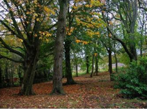
Significant Trees |
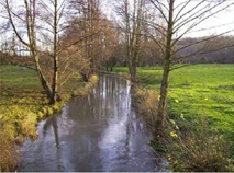
River or Stream corridors |
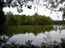
Wetlands |
Effective on: 1/1/1901
SDS 4.2 Protection of Stream Corridors & Wetlands
| Single Family | Multi-Family | Commercial | ||||||||||||||||||
| RP-1N | RP-1A | R-1A | RP-1 | R-1 | RP-2 | R-2 | RP-3 | R-3 | RP-4 | RP-5 | RP-6 | CP-0 | C-0 | CP-1 | C-1 | CP-2 | C-2 | CP-3 | C-3 | |
SDS 4.2.1 Intent.
Natural stream corridors and wetlands provide natural stormwater storage, channels, filtration, and flood control; they also successfully transition the natural landscape into the built environment. These riparian corridors shall be protected and naturally-enhanced to ensure they continue to function properly when surrounded by built environments.
SDS 4.2.2 Standard.
Streams, wetlands, and their riparian corridors shall be incorporated into developments as major amenities, with trails, seating, and appropriate supplemental vegetation. Buildings, parking areas, and other structures shall be set back from such features a sufficient distance to ensure their continued quality and natural function in accordance with 18.365 of the UDO.
SDS 4.2.3 Submittal Requirements.
As part of the submittal requirements for development, applicants shall evidence compliance with all applicable federal, state, and city laws and regulations related to preservation and protection of stream corridors and wetlands.
Effective on: 1/1/1901
SDS 4.3 Preservation of Existing Trees & Vegetation
| Single Family | Multi-Family | Commercial | |||||||||||||
| RP-2 | R-2 | RP-3 | R-3 | RP-4 | RP-5 | RP-6 | CP-0 | C-0 | CP-1 | C-1 | CP-2 | C-2 | CP-3 | C-3 | |
SDS 4.3.1 Intent.
Existing trees and vegetation shall be preserved whenever possible to act as buffers between adjoining developments and as site amenities within the development.
Standard:
SDS 4.3.2 Significant Trees.
Significant tree shall be defined as one of the following:
- Deciduous tree at least twelve (12) inches in caliper.
- Evergreen tree at least twelve (12) feet in height.
- Groups of ten (10) or more deciduous or evergreen trees with at least six (6) inches in caliper.
- Tree canopy area as determined by the City Forester.
SDS 4.3.3 Significant Tree Preservation.
Significant trees shall be preserved or transplanted on site; significant trees which cannot be preserved or transplanted shall be replaced. Preserved significant trees in appropriate locations, such as along drainage ways or along the perimeter of the site, may be used to fulfill landscaping or buffering requirements. Existing significant trees on the site shall be preserved according to the following table.
| Zoning District | R-2, RP-2, R-3, RP-3, RP-4, RP-5, RP-6, PRN | C-O, CP-O, C-1, CP-1, C-2, CP-2, C-3, CP-3 |
| Required Significant Tree Preservation | 40% min. | 20% min. |
SDS 4.3.4 Non-Significant Trees and other Vegetation.
Existing vegetation or non-significant trees that are in appropriate locations, in sufficient quantities, and of acceptable quality to be used to fulfill transition, landscaping, or buffering requirements shall be preserved.
SDS 4.3.5 Tree Survey.
Developers shall submit an existing tree survey and preservation plan for areas of the site that will be disturbed to show compliance with these standards. The City Forester shall review the tree preservation plan and tree replacement plan. The extent of the survey required shall be determined by the city.
SDS 4.3.6 Preserved Trees and Vegetation.
All preserved trees and vegetation shall be healthy and free of mechanical injury. Significant trees shall be protected during construction with the erection of barrier fencing. Grading shall be prohibited within the root area or drip line of any preserved trees.
SDS 4.3.7 Tree Replacement.
If a significant tree designated to be preserved is removed or substantially damaged during clearing, grading, or construction, the developer shall replace the removed or damaged tree with new trees. Replacement trees shall be the same or similar species to the trees removed or damaged, or a species native to Johnson County and approved by the city. For every one inch (1”) of combined total tree caliper removed or damaged, the applicant or developer shall replace two (2) inches of combined total tree caliper; if this option is prohibited by site conditions, the City Forester shall approve an equivalent tree replacement plan.
Effective on: 1/1/1901
SDS 4.4 Grading & Retaining Walls
| Single Family | Multi-Family | Commercial | |||||||||||||
| RP-2 | R-2 | RP-3 | R-3 | RP-4 | RP-5 | RP-6 | CP-0 | C-0 | CP-1 | C-1 | CP-2 | C-2 | CP-3 | C-3 | |
SDS 4.4.1 Intent.
Designing a development to fit the natural topography of the site generally results in a reduced potential for environmental problems and an improved level of visual interest and variety. To provide planting pockets or terraces for vegetation, the use of retaining walls is encouraged to reduce the steepness of man-made slopes; the use of extensive grading or unusual site improvements, such as large retaining walls, to force a preconceived design onto a particular piece of property is strongly discouraged.
Standard:
SDS 4.4.2 Grading.
Grading shall conform to the following:
- The layout of developments shall follow and respect the natural topography of the site.
- Grading to create a large level lot or site shall be minimized.
- Berms, channels, swales, and similar man-made changes to the landscape shall be designed and graded to be an integral part of the natural landscape and to provide a smooth transition in changes of slope.
SDS 4.4.3 Slopes.
The maximum slope of any man-made slope shall be 3:1.
SDS 4.4.4 Site Drainage.
Site drainage patterns shall be designed to prevent concentrated surface drainage from collecting on and flowing across pedestrian paths, walks, and sidewalks.
SDS 4.4.5 Retaining Walls.
Retaining walls shall conform to the following:
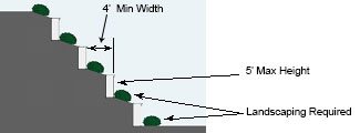
- Retaining walls may support steep slopes but shall not exceed five (5) feet in height from the finished grade. Terracing shall be limited to 4 tiers.
- The width of the terrace between any two 5-foot retaining walls shall be a minimum of four (4) feet with a maximum slope of 3:1.
- Terraces created between retaining walls shall be permanently landscaped or revegetated.
- Retaining walls shall be stone, brick, or stucco walls compatible with the primary building materials; railroad ties, timber, and gabion-type retaining walls are prohibited.
SDS 4.4.6 Retaining Walls & Drainage Easements.
Most retaining walls are prohibited from being constructed in public drainage easements. Applicants shall contact the Engineering Services Division for additional information about retaining wall restrictions in public drainage easements.
| Retaining Walls & Drainage Easements |
|---|
 |
Effective on: 1/1/1901
SDS 4.5 Stormwater Management
| Single Family | Multi-Family | Commercial | ||||||||||||||||||
| RP-1N | RP-1A | R-1A | RP-1 | R-1 | RP-2 | R-2 | RP-3 | R-3 | RP-4 | RP-5 | RP-6 | CP-0 | C-0 | CP-1 | C-1 | CP-2 | C-2 | CP-3 | C-3 | |
SDS 4.5.1 Standard.
As part of the submittal requirements for development, applicants shall evidence compliance with all applicable federal, state, and city laws and regulations related to preservation and protection of stormwater management, treatment, and conveyance.
SDS 4.5.2 Engineering Services.
Applicants shall consult the City of Overland Park Engineering Services Divisions for instruction concerning stormwater management, conveyance and treatment. The standards listed here are merely a reference and shall not be considered a list of all applicable standards.
SDS 4.5.3 Municipal Code Reference.
The following chapters of the Overland Park Municipal Code govern stormwater management, treatment, and conveyance:
- 15.06 Stormwater Management Program and Utility
- 15.10 Stormwater Management Standards and Permitting
- 16.210 Stormwater Treatment
- MARC Best Management Practices Manual
SDS 4.5.4 Design Criteria Documents.
The following documents also govern design for stormwater treatment and conveyance:
- Design Criteria - Stormwater Treatment Standards
- Design Criteria - Stormwater Conveyance Standards
- Division V - Design Criteria, Section 5600 - Storm Drainage Systems and Facilities, Kansas City APWA Standard Specifications and Design Criteria
Effective on: 1/1/1901
SDS 4.6 Setbacks
| Single Family | Multi-Family | Commercial | ||||||||||||||||||
| RP-1N | RP-1A | R-1A | RP-1 | R-1 | RP-2 | R-2 | RP-3 | R-3 | RP-4 | RP-5 | RP-6 | CP-0 | C-0 | CP-1 | C-1 | CP-2 | C-2 | CP-3 | C-3 | |
SDS 4.6.1. Intent.
Building setbacks shall create a uniformed setback along a public street. For infill, redevelopment, rehabilitation projects or new buildings in a developing site the setbacks shall match the established adjacent building setbacks.
SDS 4.6.2 Standard.
Front yard and public setbacks are regulated by the UDO and this document according to the following table.
| Setbacks | |||
|---|---|---|---|
| Zoning District | UDO Reference | Applies to All Development (Includes Redevelopment & Infill Development) | Applies Only to Redevelopment & Infill Development |
| Note 1: Shall not apply if the single-family residential development has already been preliminarily platted. A 30 feet setback would be required for the approved plats. Note 2: All new buildings along the perimeter of a partially-developed office complex shall meet the established building setbacks. Note 3: Shall not apply for office buildings in an established office development prior to the adoption of these standards. |
|||
| R-1, RP-1 | 18.180.030 |
|
|
| R-1A, RP-1A | 18.190.030 |
|
|
| RP-1N | 18.195.030 | ||
| R-2, RP-2 | 18.200.030 |
|
|
| R-3, RP-3 | 18.210.030 |
|
|
| RP-4 | 18.220.030 | ||
| RP-5 | 18.230.030 | ||
| RP-6 | 18.240.030 | ||
| PRN | 18.245.030 |
|
|
| C-O, CP-O | 18.250.030 |
|
|
| C-1, CP-1 | 18.260.030 |
|
|
| C-2, CP-2 | 18.270.030 | ||
| C-3, CP-3 | 18.280.030 | ||
Effective on: 1/1/1901
SDS 4.7 Pedestrian Access & Circulation
| Single Family | Multi-Family | Commercial | ||||||||||||||||||
| RP-1N | RP-1A | R-1A | RP-1 | R-1 | RP-2 | R-2 | RP-3 | R-3 | RP-4 | RP-5 | RP-6 | CP-0 | C-0 | CP-1 | C-1 | CP-2 | C-2 | CP-3 | C-3 | |
SDS 4.7.1 Intent.
The design of pedestrian walkways shall encourage walking through its size, location, and connectivity.
Standard:
SDS 4.7.2 Dimensional Standards.
All on-site pedestrian walkways and sidewalks shall be a minimum of five (5) feet wide, except walkways adjacent to a parking area, where cars may overhang the walkway, shall be a minimum of seven (7) feet wide.
SDS 4.7.3 Pedestrian Connections.
An on-site system of pedestrian walkways shall be designed to provide direct access and connections to and between the following:
- Front doors and/or front entrances on building fronts.
- The primary entrance or entrances to each building, including pad site buildings.
- Any sidewalks or walkways on adjacent properties that extend to the boundaries shared with the development.
- Any public sidewalk system along the perimeter streets adjacent to the development.
- Adjacent land uses and developments, including, but not limited to, adjacent residential developments, retail shopping centers, office buildings, or restaurants.
- Any adjacent public park, greenway, or other public or civic use including, but not limited to, schools, places of worship, public recreational facilities, or government offices.
- Unless unfeasible due to site constraints, all walkways shall meet ADA requirements.
SDS 4.7.4 Pedestrian Connections from Buildings to Parking Areas, Pad Sites, and Site Amenities.
On-site pedestrian walkways shall connect each primary entrance to a pedestrian network serving:
- All parking areas or parking structures that serve such primary building.
- Site amenities or gathering places provided.
SDS 4.7.5 Pedestrian Connections to Perimeter Public Sidewalks.
Connections between the on-site pedestrian walkway network and any public sidewalk system located along adjacent perimeter streets shall be provided at regular intervals along the perimeter street as appropriate to provide easy access from the public sidewalk to the interior walkway network.
SDS 4.7.6 Private Sidewalk Standards.
The following sections of the UDO shall also govern private sidewalks:
- 18.120.015.
- 18.130.015.
Effective on: 1/1/1901
SDS 4.8 Parking
| Single Family | Multi-Family | Commercial | ||||||||||||||||||
| RP-1N | RP-1A | R-1A | RP-1 | R-1 | RP-2 | R-2 | RP-3 | R-3 | RP-4 | RP-5 | RP-6 | CP-0 | C-0 | CP-1 | C-1 | CP-2 | C-2 | CP-3 | C-3 | |
SDS 4.8.1 Required Parking Spaces.
Parking standards are regulated by the UDO in 18.430.
SDS 4.8.2 On-Street Parking.
On-street parking spaces may be counted towards the minimum requirements as set forth in UDO 18.430.
SDS 4.8.3 Parking Setbacks.
Parking setbacks are regulated by the UDO in 18.430.
SDS 4.8.4 Accessible Parking.
See 18.430 in the UDO.
SDS 4.8.5 Reduced Parking.
See 18.430 in the UDO.
Effective on: 1/1/1901
SDS 4.9 Plant Materials
| Single Family | Multi-Family | Commercial | ||||||||||||||||||
| RP-1N | RP-1A | R-1A | RP-1 | R-1 | RP-2 | R-2 | RP-3 | R-3 | RP-4 | RP-5 | RP-6 | CP-0 | C-0 | CP-1 | C-1 | CP-2 | C-2 | CP-3 | C-3 | |
SDS 4.9.1 Intent.
Plant species that have been proven over time to grow well in both the climate of Overland Park and within the micro-climates of their planting condition shall be used for landscaping.
SDS 4.9.2 Standard.
Standards for plant materials, including allowed and prohibited plant species, are specified by UDO 7.16.
SDS 4.9.3 Suitable Species.
Unless irrigation is provided, species should be selected that are capable of thriving once established in the climate of Overland Park, Kansas.
Effective on: 1/1/1901
SDS 4.10 Street Trees
| Single Family | Multi-Family | Commercial | ||||||||||||||||||
| RP-1N | RP-1A | R-1A | RP-1 | R-1 | RP-2 | R-2 | RP-3 | R-3 | RP-4 | RP-5 | RP-6 | CP-0 | C-0 | CP-1 | C-1 | CP-2 | C-2 | CP-3 | C-3 | |
SDS 4.10.1 Intent.
Street trees provide a continuous, shaded environment along street edges; they provide both shade and visual enclosure to streets and reduce heat island effects. When planted correctly, street trees also provide a physical and visual barrier between a pedestrian on the sidewalk and vehicles traveling on the roadway.
Standard:
SDS 4.10.2 Street Trees.
Street trees are required along all streets and roadways. Street trees shall provide both a continuous, shaded environment along roadways and a physical and visual barrier between a pedestrian on the sidewalk and vehicles on the roadway. Alleys and service drives shall not be considered streets or roadways for the purposes of this standard.
SDS 4.10.3 Standards and Species.
Street trees shall conform to the standards provided in the following table.
| Street Tree Standards | |
|---|---|
| Species |
Street tree species shall conform to 7.16 of the Municipal Code and shall be listed in a street tree schedule in the project design manual. |
| Size |
Large deciduous canopy trees shall be two (2) inches caliper minimum at planting; small deciduous ornamental trees shall be one and one-half (1-1/2) inches caliper minimum at planting. |
| Spacing |
Street tree spacing shall be determined by the mature size of the tree and site features such as infrastructure and utilities; street tree spacing shall be a minimum of fifteen (15) feet and a maximum of forty (40) feet for the full length of all streets and roadways. |
| Configuration |
Street trees shall be planted in a row that extends the full length of all streets and roadways. |
| Location |
Street trees shall be planted within the right-of-way of all streets, accessways, and roadways, excluding thoroughfares, alleys, and service drives. If not allowed within a thoroughfare right-of-way, street trees shall be planted on the private lots along the thoroughfare right-of way. |
| Clearances |
Street trees shall be planted at least three (3) feet from any curb or sidewalk. |
SDS 4.10.4 Submittal of Landscape Plan.
With the submittal of the required landscape plan, all street tree placement shall consider the location of site distance triangles, utilities, street lights, and other public improvements. The landscape plan shall be submitted with all public improvement plans in addition to the other submittal requirements.
| Don't Do This: | |
|---|---|
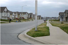
This street has a tree lawn with no street trees. |
| Do This: | |
|---|---|
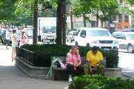
This street tree is correctly located in a tree planter along a curb. |
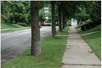
These street trees are correctly located in a tree lawn between the curb and the sidewalk. |
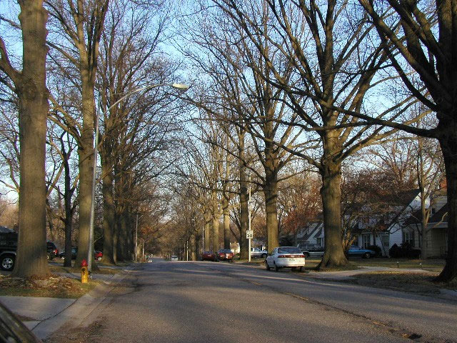
The left side of this street has no sidewalk; the street trees are correctly located along the curb. |
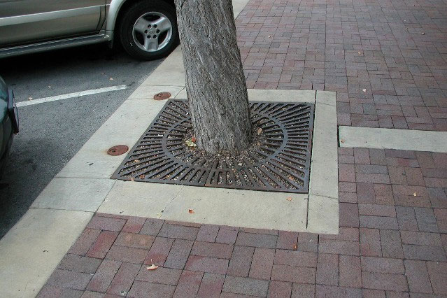
This street tree is correctly located in a tree well along a curb. |
Effective on: 1/1/1901
SDS 4.11 Site Perimeter Landscaping
| Single Family | Multi-Family | Commercial | |||||||||||||
| RP-2 | R-2 | RP-3 | R-3 | RP-4 | RP-5 | RP-6 | CP-0 | C-0 | CP-1 | C-1 | CP-2 | C-2 | CP-3 | C-3 | |
SDS 4.11.1 Intent.
Landscaping along the site perimeter provides an adequate transition between dissimilar land uses.
Standard:
SDS 4.11.2 Site Perimeter.
The site perimeter shall be all site boundaries that do not abut a public street.
SDS 4.11.3 Required Landscaping.
When required, the site perimeter shall be landscaped with both of the following:
- Four (4) shade trees per 100 linear feet.
- 20 shrubs per 100 linear feet; conifers may be substituted for shrubs at a ratio of one (1) conifer tree for every four (4) shrubs.
SDS 4.11.4 Required Site Perimeters.
Site perimeter landscaping shall be required according to the following table.
| Required Site Perimeter Landscaping along a Site Perimeter that abuts this existing or master-planned district | |||||
| Development Site District | C-0 C-1 C-2 C-3 |
CP-0 CP-1 CP-2 CP-3 |
R-3 RP-3 RP-4 RP-5 RP-6 |
R-1 RP-1 R-1A RP-1A RP-1N |
R-2 RP-2 PRN |
| C-0, CP-0, C-1, CP-1, C-2, CP-2, C-3, CP-3 | Not Required | Required | Required | ||
| R-3, RP-3, RP-4, RP-5, RP-6 | Not Required | Not Required | Required | ||
| R-2, RP-2, PRN | Not Required | Not Required | Not Required | ||
| Site Perimeter | |
.jpg) |
_NT.jpg)
This is site perimeter screening a multi-family development from single-family. |
Effective on: 1/1/1901
SDS 4.12 Site Entryway Landscaping
| Single Family | Multi-Family | Commercial | ||||||||||||||||||
| RP-1N | RP-1A | R-1A | RP-1 | R-1 | RP-2 | R-2 | RP-3 | R-3 | RP-4 | RP-5 | RP-6 | CP-0 | C-0 | CP-1 | C-1 | CP-2 | C-2 | CP-3 | C-3 | |
SDS 4.12.1 Intent.
Site entryway landscaping highlights entries into the development.
Standard:
SDS 4.12.2 UDO Reference.
Site entryway landscaping shall conform to UDO Section 18.420.060 Yard Exceptions.
SDS 4.12.3 Species.
Development entryways that are landscaped or contain development monuments or signage shall be planted with ornamental plant material, such as ornamental trees, flowering shrubs, perennials, and ground covers.
SDS 4.12.4 Configuration.
Plantings shall be massed and scaled as appropriate for the entryway size and space. Landscaping at street intersections and driveway corners shall “pull back” to open view lines into the site and to create corner features.
| Configuration | |
|---|---|
.jpg)
Plantings that pull back from the intersection provide adequate view lines for vehicles and pedestrians. |
(1).jpg)
Landscaping stays low in front of signage and gradually gets larger further from the intersection. |
Effective on: 1/1/1901
SDS 4.13 Parking Lot Perimeter Landscaping
| Single Family | Multi-Family | Commercial | |||||||||||||
| RP-2 | R-2 | RP-3 | R-3 | RP-4 | RP-5 | RP-6 | CP-0 | C-0 | CP-1 | C-1 | CP-2 | C-2 | CP-3 | C-3 | |
SDS 4.13.1 Intent.
Perimeter landscaping shall be used to screen parking lots both visually and acoustically.
Standard:
SDS 4.13.2 Required Landscaping.
The perimeter of all parking areas shall be screened from adjacent streets, public sidewalks, public open space, and adjacent uses; parking perimeter landscaping is not required where site perimeter landscaping is required along abutting parcels.
SDS 4.13.3 Configuration.
Parking lot perimeter landscaping shall consist of one, or a combination, of the following:
- Berm. A berm three (3) feet high with a maximum slope of 3:1 in combination with coniferous and deciduous trees and shrubs.
- Hedge. A low continuous landscaped hedge at least three (3) feet high, planted with a combination of coniferous and deciduous shrubs in a triangular pattern so as to achieve full screening at maturity.
- Wall. A low decorative masonry wall no more than three (3) feet high in combination with landscaping. Masonry wall material shall match the materials of the building.
- Fence. A low decorative wrought iron fence no more than three (3) feet high in combination with landscaping planted so as to achieve full screening at maturity.
| Parking Lot Perimeter Landscaping | |
|---|---|
.jpg) |
.jpg) |
.jpg) |
|
Effective on: 1/1/1901
SDS 4.14 Parking Lot Landscaping
| Single Family | Multi-Family | Commercial | |||||||||||||
| RP-2 | R-2 | RP-3 | R-3 | RP-4 | RP-5 | RP-6 | CP-0 | C-0 | CP-1 | C-1 | CP-2 | C-2 | CP-3 | C-3 | |
SDS 4.14.1 Intent.
Landscaping between parking blocks shall be used to screen parking lots.
Standard:
SDS 4.14.2 Parking Blocks.
Parking block size is specific to either multi-family or commercial development and is defined in the Parking Location and Layout standard of this document (See Sections SDS 5.13 and SDS 6.15).
SDS 4.14.3 Separation of Parking Blocks.
Each parking block shall be separated from other parking blocks by one of the following:
- Landscaped Median at least seven (7) feet wide.
- Pedestrian Walkway within a landscaped median that is at least ten (10) feet wide.
- Decorative Fence or Wall no more than three (3) feet high bordered by landscaping on at least one side.
- Rain Garden at least seven (7) feet wide.
SDS 4.14.4 Landscaping Materials.
The primary landscaping materials used shall be trees which provide shade or are capable of providing shade at maturity. Shrubs, hedges, and other planting materials may be used to complement the tree landscaping, but shall not be the sole means of landscaping.
SDS 4.14.5 Garages and Carports Landscaping.
A landscaped area no less than ten (10) feet wide shall separate detached garages or carport structures sited in a row (end-to-end). The area shall be planted with at least one (1) deciduous tree and ground cover or sod.
SDS 4.14.6 Lighting.
Lighting for parking lots may be contained within a parking lot landscaped area provided the landscaped area is a minimum of 200 square feet in area and provided the landscaping and trees, at maturity and as maintained, shall not obstruct the illumination path. It is encouraged to provide triangular landscaped beds in parking lots for additional trees and as a place for parking lot lights.
| Parking Lot Landscaping | ||
|---|---|---|
.jpg)
Landscaped median with trees and shrubs between parking blocks. |
.jpg)
Landscaped median with trees, shrubs, and a walkway between parking blocks. |
.jpg)
Landscaped median with trees, a planter, and a walkway between parking blocks. |
Effective on: 1/1/1901
SDS 4.15 Signage
| Single Family | Multi-Family | Commercial | |||||||||||||
| RP-2 | R-2 | RP-3 | R-3 | RP-4 | RP-5 | RP-6 | CP-0 | C-0 | CP-1 | C-1 | CP-2 | C-2 | CP-3 | C-3 | |
SDS 4.15.1 Intent.
Signage shall be scaled appropriately to appeal to both pedestrians and vehicles.
Standard:
SDS 4.15.2 Sign Ordinance.
Please reference UDO 18.440.
SDS 4.15.3 Project Identification Signs.
Project signs for shopping centers shall not consist primarily of large, flat, backlit panels. These signs should blend multiple materials, three-dimensional elements, and creative lighting effects in a way that communicates effectively and complements the design of the development.
| Signage | |
|---|---|
.jpg) |
(1).jpg) |
Effective on: 1/1/1901
SDS 4.16 Screening
| Single Family | Multi-Family | Commercial | |||||||||||||
| RP-2 | R-2 | RP-3 | R-3 | RP-4 | RP-5 | RP-6 | CP-0 | C-0 | CP-1 | C-1 | CP-2 | C-2 | CP-3 | C-3 | |
SDS 4.16.1 Intent.
To avoid visual and noise impacts on surrounding uses and neighborhoods, service areas shall be screened.
Standard:
SDS 4.16.2 UDO Reference.
Screening shall comply with UDO Section 18.450.100.
SDS 4.16.3 Areas for Outdoor Storage, Truck Parking, Trash Collection or Compaction, Loading, or Other Such Service Areas
Areas for outdoor storage, truck parking, trash collection or compaction, loading, or other such service areas shall not be visible from abutting streets and shall be oriented toward on-site service corridors. No areas for outdoor storage, trash collection or compaction, loading, or other such uses shall be located within 20 feet of any public street or public sidewalk.
SDS 4.16.4 Loading Docks, Truck Parking, Outdoor Storage, Trash Collection, Trash Compaction, and Other Service Functions
Loading docks, truck parking, outdoor storage, trash collection, trash compaction, and other service functions shall be incorporated into the overall design of the building and landscaping so that the visual and acoustic impacts of these functions are fully contained and out of view from adjacent properties and public streets. Screening materials shall be the same as, or of equal quality to, the materials used for the primary building and landscaping.
SDS 4.16.5 Non-enclosed Areas for the Storage and Sale of Seasonal Inventory or Vending Machines
Non-enclosed areas for the storage and sale of seasonal inventory or vending machines shall be permanently defined and enclosed with landscaping, walls or fences. Materials, colors, and design of screening walls or fences, and of any covering for such area, shall be compatible with those used as predominant materials and colors on the primary building(s). The height of stored or displayed inventory not in a building or structure shall generally not exceed ten (10) feet above grade.
Effective on: 1/1/1901
SDS 4.17 Service Compatibility
| Single Family | Multi-Family | Commercial | |||||||||||||
| RP-2 | R-2 | RP-3 | R-3 | RP-4 | RP-5 | RP-6 | CP-0 | C-0 | CP-1 | C-1 | CP-2 | C-2 | CP-3 | C-3 | |
SDS 4.17.1 Intent.
The provision of services is sometimes located in areas that are incompatible with abutting land uses; services and their associated activities shall be designed to ensure that land uses are not adversely affected by the new development.
Standard:
SDS 4.17.2 General to all Multi-family & Commercial Districts.
The city may impose conditions upon the approval of development applications to ensure that development will be compatible with existing neighborhoods and uses. Items that may require additional standards may include but not be limited to the following:
- Placement of trash receptacles.
- Location of delivery and loading zones.
- Placement and illumination of outdoor vending machines.
- Views, uses, or activities on the commercial development site that could be a nuisance for neighbors, such as commercial loading and service areas.
- Orient potentially bothersome or nuisance features or uses away from neighboring uses. For example, avoid placing garages, parking lots, or service areas facing the fronts of neighboring buildings.
- Placement of group mailboxes.
SDS 4.17.3 Specific to Multi-family Districts.
When any portion of a building or structure is located adjacent to property used or zoned for lower-density residential, the following standards shall apply to ensure the privacy of nearby residents:
- Accessory Structures. Accessory structures, including garages and recreational facilities, shall be set back at least 25 feet from the adjacent property designated on the Future Development Plan Map for low-density residential uses, and the developer shall provide a buffer between the structure and adjacent property. The buffer may be a fence, wall, heavy landscaping, or combination thereof.
Effective on: 1/1/1901
SDS 5.1 Transitions Between Land Uses
| Commercial | |||||||
| CP-0 | C-0 | CP-1 | C-1 | CP-2 | C-2 | CP-3 | C-3 |
SDS 5.1.1 Intent.
Typical commercial developments that abut low density residential districts generally provide a harsh and abrupt transition from commercial to residential development; commercial developers shall design the built environment in such a way that softens the transition.
SDS 5.1.2 Standard.
Transitions shall be required for a commercially zoned development if an adjoining property is residentially zoned. An applicant shall use at least one (1) of the following transitions:
- Use similar building setback.
- Use small green spaces, courts, squares, parks, plazas, and similar spaces.
- Use existing natural features as transitions, including natural differences in topography (not retaining walls), streams, existing stands of trees, and similar features. When existing natural features are used as transitions, the city may still require that adequate pedestrian connections to adjacent land uses be accommodated.
- Site small-scale retail, office, pedestrian-intensive retail, civic, or public uses as transitions to lower-intensity, adjacent uses. For example, post offices, banks, and restaurants are pedestrian-intensive, community-serving uses and may be sited next to adjacent medium- density residential uses.
Effective on: 1/1/1901
SDS 5.2 Sites At Intersecting Thoroughfares
| Commercial | |||||||
| CP-0 | C-0 | CP-1 | C-1 | CP-2 | C-2 | CP-3 | C-3 |
SDS 5.2.1 Intent.
Intersections of commercial activity need special attention so that all four corners are linked and function as a whole; focal points help to give the intersection a sense of place.
SDS 5.2.2 Standard.
Developments located at the intersection of two thoroughfares shall comply with the standards in this section.
SDS 5.2.3 Focal Points.
On each of the four corners of two intersecting thoroughfares, developments shall provide a focal point within 200 feet of the intersection of the centerlines of the two thoroughfare streets; the focal point shall be within 300 feet of the intersection of the centerlines of a thoroughfare street and 135th Street. A focal point shall be visible from the intersecting thoroughfares and shall consist of one (1) of the following:
- A distinctively-designed building, which may include a pad site building, preferably with a vertical element, but shall not include drive-through facilities or automobile service stations.
- An architectural feature that is a minimum of 25 feet tall and a maximum 45 feet tall (e.g., a clock tower, spire, or interesting roof form).
- Public art or sculpture.
- Fountains or other water feature.
- Public plazas or other open space.
SDS 5.2.4 Cohesive with Existing Development.
The focal point shall be cohesive with the design on at least one of the other corners.
SDS 5.2.5 Integration with Signage.
Any focal point may be integrated with major entryway signage for the development. With city approval, a focal point may be used to satisfy the site amenity requirement. (See Section SDS 5.7).
SDS 5.2.6 Building Orientation.
Within each intersection quadrant, buildings shall be arranged to orient to the thoroughfares and to frame the corner at the intersection of the two thoroughfares. Deep building setbacks behind large expanses of parking areas or vacant land shall be avoided.
SDS 5.2.7 Prohibited Parking Areas.
Parking areas shall not be located within 200 feet of the intersection of the centerlines of the two thoroughfares; parking areas shall not be located within 300 feet of the intersection of the centerlines of a thoroughfare and 135th Street.
SDS 5.2.8 Prohibited Parking Area Exemption.
Parking areas may be located within the prohibited parking area if the parking area is visually screened by building(s) or focal point(s).
| Prohibited Parking Lot Zones at Intersecting Thoroughfares |
|---|
.jpg) |
| Focal Point Examples | |
|---|---|
.jpg) |
(1).jpg) |
.jpg) |
(1).jpg) |
Effective on: 1/1/1901
SDS 5.3 Development Patterns
SDS 5.3.1 Development Patterns: All
| Commercial | |||||||
| CP-0 | C-0 | CP-1 | C-1 | CP-2 | C-2 | CP-3 | C-3 |
SDS 5.3.1.1 Intent.
Buildings that enclose an outdoor space tend to create a comfortable human environment; developments shall arrange their buildings to define and enclose a street, green, or square.
Standard:
SDS 5.3.1.2 Development Patterns.
Multiple building developments that are of an appropriate scale and size shall be arranged in one of the following development patterns.
| Development Patterns |
|---|
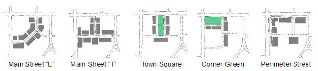
|
SDS 5.3.1.3 Existing Development.
Buildings shall be arranged so that their orientation complements adjacent, existing development.
SDS 5.3.2 Development Patterns: Main Street “L”
| Commercial | |||||||
| CP-0 | C-0 | CP-1 | C-1 | CP-2 | C-2 | CP-3 | C-3 |
SDS 5.3.2.1 Intent.
The intent of the Main Street “L” Development Pattern is to provide a main street commercial environment with sidewalks and buildings located up close to a through-site accessway.
SDS 5.3.2.2 Standard.
A development classified as having a Main Street “L” Development Pattern shall adhere to the following characteristics.
SDS 5.3.2.3 Primary Amenity of the Main Street “L” Development Pattern.
The primary amenity provided by the Main Street "L" Development Pattern shall be a main street commercial environment with sidewalks and buildings located up close to a through-site accessway.
| Example Illustrative Plan for a Development Using a Main Street “L” Development Pattern | |
|---|---|
.jpg) . . |
 |
|
|
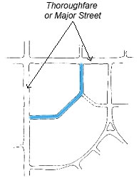
SDS 5.3.2.4 Primary Vehicular Pattern.The primary vehicular circulation pattern, illustrated in this diagram, consists of one major through accessway arranged in an “L” or “C” pattern. |
 |
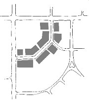 |
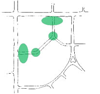
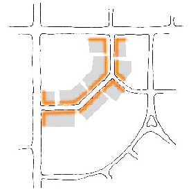
SDS 5.3.2.5 Location of Greens, Squares, and Plazas.This diagram highlights the appropriate areas for locating greens, plazas, squares, or other similar areas that may be included in the development. |
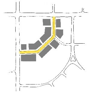
SDS 5.3.2.6 Building Location.This diagram conceptually illustrates the appropriate location for buildings: the buildings should be located along and on both sides of the through accessway. |
 |
 |
SDS 5.3.2.7 Building Fronts.This diagram illustrates what building facades in this pattern are classified as building fronts. |
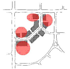
SDS 5.3.2.8 Location of Large Footprint Buildings.This diagram highlights locations that would most likely be appropriate for the location of large footprint buildings. |
 |
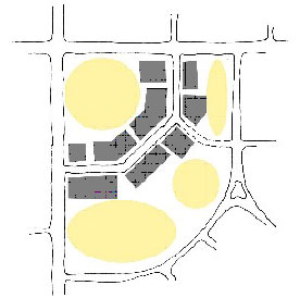 |
SDS 5.3.2.9 Curbside Parking.This diagram highlights the appropriate location for on-street (curbside) parking; this parking may be parallel or angled at 45 degrees. |
SDS 5.3.2.10 Parking Lots.This diagram highlights the appropriate location for parking lots. |
SDS 5.3.3 Development Patterns: Main Street “T”
| Commercial | |||||||
| CP-0 | C-0 | CP-1 | C-1 | CP-2 | C-2 | CP-3 | C-3 |
SDS 5.3.3.1 Intent.
The intent of the Main Street “T” Development Pattern is to provide a main street commercial environment with sidewalks and buildings located up close to two intersecting accessways.
SDS 5.3.3.2 Standard.
A development classified as having a Main Street “T” Development Pattern shall adhere to the following characteristics.
SDS 5.3.3.3 Primary Amenity of the Main Street “T” Development Pattern.
The primary amenity provided by the Main Street “T” Development Pattern shall be a main street commercial environment with sidewalks and buildings located up close to two intersecting accessways.
| Example Illustrative Plan for a development using a Main Street “T” Development Pattern | |
|---|---|
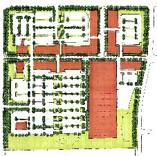 |
 |
Note: The example plan provided is for explanatory purposes only; this plan does not represent a project that is currently in the planning or development phase. Inclusion of this example does not imply, explicitly or implicitly, its approval for construction by the city. The street and accessway locations in this example are conceptual and may need to be adjusted based on conditions along the adjoining streets or thoroughfares. |
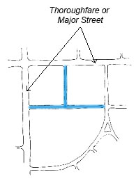
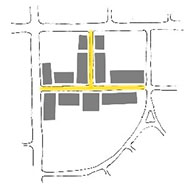
SDS 5.3.3.4 Primary Vehicular Pattern.The primary vehicular circulation pattern, illustrated in this diagram, consists of two accessways arranged in a “T” pattern. |
 |
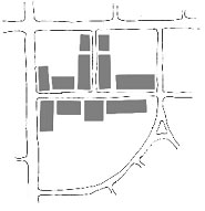 |
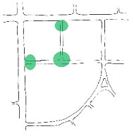
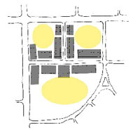
SDS 5.3.3.5 Location of Greens, Squares, and Plazas.This diagram highlights the appropriate areas for locating greens, plazas, squares, or other similar areas that may be included in the development. |
SDS 5.3.3.6 Building Location.This diagram conceptually illustrates the appropriate location for buildings: the buildings should be located along and on both sides of the two intersecting accessways. |
|
|
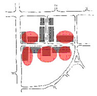 |
SDS 5.3.3.7 Building Fronts.This diagram illustrates what building facades in this pattern are classified as building fronts. |
SDS 5.3.3.8 Location of Large Footprint Buildings.This diagram highlights locations that would most likely be appropriate for the location of large footprint buildings. |
 |
 |
SDS 5.3.3.9 Curbside Parking.This diagram highlights the appropriate location for on-street (curbside) parking; this parking may be parallel or angled at 45 degrees. |
SDS 5.3.3.10 Parking Lots.This diagram highlights the appropriate location for parking lots. |
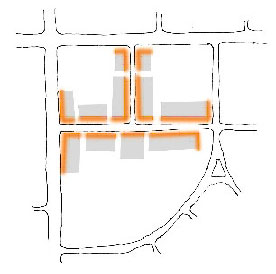
SDS 5.3.4 Development Patterns: Town Square
| Commercial | |||||||
| CP-0 | C-0 | CP-1 | C-1 | CP-2 | C-2 | CP-3 | C-3 |
SDS 5.3.4.1 Intent.
The intent of the Town Square Development Pattern is to provide a commercial environment with sidewalks, buildings and accessways surrounding a centralized green, square, or plaza on at least three sides.
SDS 5.3.4.2 Standard.
A development classified as having a Town Square Development Pattern shall adhere to the following characteristics.
SDS 5.3.4.3 Primary Amenity of the Town Square Development Pattern.
The primary amenity provided by the Town Square Development Pattern shall be a commercial environment with sidewalks, buildings and accessways surrounding a centralized green, square, or plaza on at least three sides.
| Example Illustrative Plan for a development using a Town Square Development Pattern | |
|---|---|
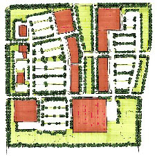 |
 |
Note: The example plan provided is for explanatory purposes only; this plan does not represent a project that is currently in the planning or development phase. Inclusion of this example does not imply, explicitly or implicitly, its approval for construction by the city. The street and accessway locations in this example are conceptual and may need to be adjusted based on conditions along the adjoining streets or thoroughfares. |
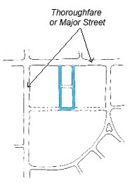
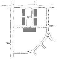
SDS 5.3.4.4 Primary Vehicular Pattern.The primary vehicular circulation pattern, illustrated in this diagram, consists of two parallel accessways surrounding at least three sides of a green or square. |
 |
 |
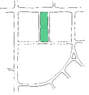
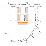
SDS 5.3.4.5 Location of Greens, Squares, and Plazas.This diagram highlights the appropriate area for locating the green, plaza, or square in the development. |
SDS 5.3.4.6 Building Location.This diagram conceptually illustrates the appropriate location for buildings: the buildings should be located along at least three sides of the green, square, or plaza surrounded by the primary accessways. |
 |
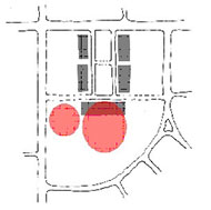 |
SDS 5.3.4.7 Building Fronts.This diagram illustrates what building facades in this pattern are classified as building fronts. |
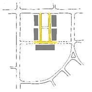
SDS 5.3.4.8 Location of Large Footprint Buildings.This diagram highlights locations that would most likely be appropriate for the location of large footprint buildings. |
 |
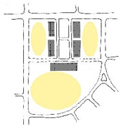 |
SDS 5.3.4.9 Curbside Parking.This diagram highlights the appropriate location for on-street (curbside) parking; this parking may be parallel or angled at 45 degrees. |
SDS 5.3.4.10 Parking Lots.This diagram highlights the appropriate location for parking lots. |
SDS 5.3.5 Development Patterns: Corner Green
| Commercial | |||||||
| CP-0 | C-0 | CP-1 | C-1 | CP-2 | C-2 | CP-3 | C-3 |
SDS 5.3.5.1 Intent.
The intent of the Corner Green Development Pattern is to provide a commercial environment with sidewalks, buildings and accessways surrounding on at least two sides a green, square, or plaza located at an intersection.
SDS 5.3.5.2 Standard.
A development classified as having a Corner Green Development Pattern shall adhere to the following characteristics.
SDS 5.3.5.3 Primary Amenity of the Corner Green Development Pattern.
The primary amenity provided by the Corner Green Development Pattern shall be a commercial environment with sidewalks, buildings and accessways surrounding on at least two sides a green, square, or plaza located at an intersection.
| Example Illustrative Plan for a development using a Corner Green Development Pattern | |
|---|---|
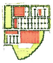
|
|
Note: The example plan provided is for explanatory purposes only; this plan does not represent a project that is currently in the planning or development phase. Inclusion of this example does not imply, explicitly or implicitly, its approval for construction by the city. The street and accessway locations in this example are conceptual and may need to be adjusted based on conditions along the adjoining streets or thoroughfares. |
SDS 5.3.5.4 Primary Vehicular Pattern.The primary vehicular circulation pattern, illustrated in this diagram, consists of accessways surrounding at least two sides of a green located at an intersection. |
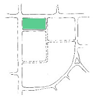 |
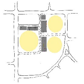
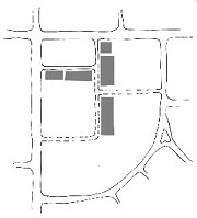 |
SDS 5.3.5.5 Location of Greens, Squares, and Plazas.This diagram highlights the appropriate area for locating the green, plaza, or square in the development. |
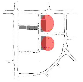
SDS 5.3.5.6 Building Location.This diagram conceptually illustrates the appropriate location for buildings: the buildings should be located along at least two sides of the green, square, or plaza surrounded by the primary accessways. |
 |
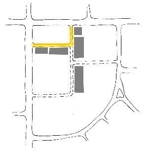
 |
SDS 5.3.5.7 Building Fronts.This diagram illustrates what building facades in this pattern are classified as building fronts. |
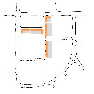
SDS 5.3.5.8 Location of Large Footprint Buildings.This diagram highlights locations that would most likely be appropriate for the location of large footprint buildings. |
 |
 |
SDS 5.3.5.9 Curbside Parking.This diagram highlights the appropriate location for on-street (curbside) parking; this parking may be parallel or angled at 45 degrees. |
SDS 5.3.5.10 Parking Lots.This diagram highlights the appropriate location for parking lots. |
SDS 5.3.6 Development Patterns: Perimeter Street
| Commercial | |||||||
| CP-0 | C-0 | CP-1 | C-1 | CP-2 | C-2 | CP-3 | C-3 |
SDS 5.3.6.1 Intent.
The intent of the Perimeter Street Development Pattern is to provide a defined street edge with buildings located along a thoroughfare or street. Pedestrian activity, amenities, and focal points are located in close proximity to each other.
SDS 5.3.6.2 Standard.
A development classified as having a Perimeter Street Development Pattern shall adhere to the following characteristics.
SDS 5.3.6.3 Primary Amenity of the Perimeter Street Development Pattern.
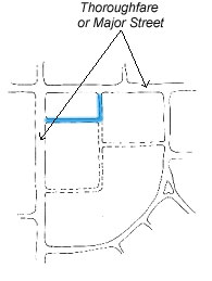
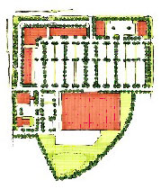
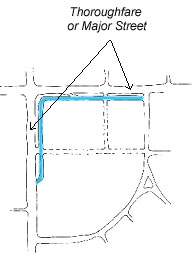
The primary amenity provided by the Perimeter Street Development Pattern shall be a commercial environment with sidewalks and buildings lining an accessway running parallel to the thoroughfare or major street. In some instances, the parallel accessway may be eliminated and the buildings located at the setback line adjacent to the thoroughfare or public street. The connections between the parallel accessways and intersecting major drives need to be carefully designed to avoid conflicts with turning movements onto and off of the adjoining public streets.
| Example Illustrative Plan for a development using a Perimeter Street Development Pattern | |
|---|---|
 |
 |
Note: The example plan provided is for explanatory purposes only; this plan does not represent a project that is currently in the planning or development phase. Inclusion of this example does not imply, explicitly or implicitly, its approval for construction by the city. The street and accessway locations in this example are conceptual and may need to be adjusted based on conditions along the adjoining streets or thoroughfares. |
SDS 5.3.6.4 Primary Vehicular Pattern.The primary vehicular circulation pattern, illustrated in this diagram, consists of an accessway running parallel to the thoroughfare or major street. |
 |
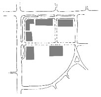 |
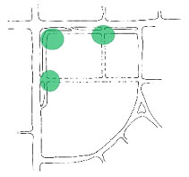
SDS 5.3.6.5 Location of Greens, Squares, and Plazas.This diagram highlights the appropriate areas for locating greens, plazas, squares, or other similar areas that may be included in the development. |
SDS 5.3.6.6 Building Location.This diagram conceptually illustrates the appropriate location for buildings: they should be located along and on both sides of the accessway running parallel to the thoroughfare or major street. |
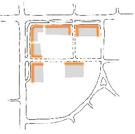 |
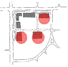 |
SDS 5.3.6.7 Building Fronts.This diagram illustrates what building facades in this pattern are classified as building fronts. |
SDS 5.3.6.8 Location of Large Footprint Buildings.This diagram highlights locations that would most likely be appropriate for the location of large footprint buildings. |
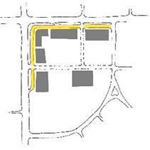 |
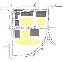 |
SDS 5.3.6.9 Curbside Parking.This diagram highlights the appropriate location for on-street (curbside) parking; this parking may be parallel or angled at 45 degrees. |
SDS 5.3.6.10 Parking Lots.This diagram highlights the appropriate location for parking lots. |
Effective on: 1/1/1901
SDS 5.4 Developments Not Using a Development Pattern
| Commercial | |||||||
| CP-0 | C-0 | CP-1 | C-1 | CP-2 | C-2 | CP-3 | C-3 |
SDS 5.4.1 Intent.
A development which is not of the size or scale to meet the standards for a defined development pattern shall be oriented to face towards a street; a building that turns its back to the street tends to give a lifeless and dull quality to the streetscape.
Standard:
SDS 5.4.2 Orientation.
When there is no more than one building in a proposed development and the building is not part of a larger planned development or the development is not of the size or scale to meet the standards for a defined development pattern, the building shall orient its active wall toward the primary abutting street. Deep setbacks behind large expanses of parking or vacant land shall be avoided.
SDS 5.4.3 Active Wall.
The active wall shall be the side of the building containing the majority of storefronts, public entrances and windows.
SDS 5.4.4 Single Tenant Building.
A building occupied by a single tenant shall orient 100% of its active wall to the primary abutting street.
SDS 5.4.5 Multi Tenant Building.
A building occupied by more than one tenant shall orient at least 50% of its active wall to the primary abutting street.
| Active and Non-Active Walls |
|---|
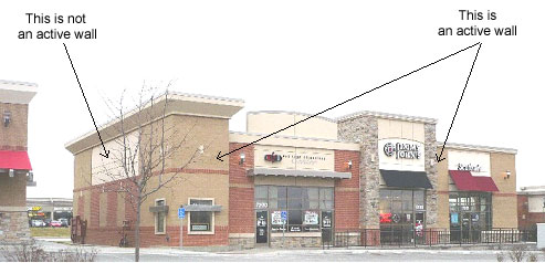 |
Effective on: 1/1/1901
SDS 5.5 Pad Sites
| Commercial | |||||||
| CP-0 | C-0 | CP-1 | C-1 | CP-2 | C-2 | CP-3 | C-3 |
SDS 5.5.1 Intent.
Pad site buildings that ignore the surrounding development appear out-of-place and isolated; pad site buildings shall be designed to complement and enhance the rest of the development.
Standard:
SDS 5.5.2 Clustering.
Pad sites shall be clustered together to define street edges and entry points or to enclose and create focal points or public places between buildings. Uniform spacing of pad sites in a widely-spaced pattern within the development, even if along a street edge, is discouraged.
SDS 5.5.3 Spaces Between Adjacent Pad Sites.
Spaces between adjacent pad site buildings should be enhanced to provide small pockets (preferably heavily-landscaped) of customer parking, pedestrian connections, small-scale project amenities, or focal points. Examples include, but shall not be limited to, the following:
- A landscaped pedestrian walkway linking customer entrances between two or more pad site buildings.
- A public seating or outdoor eating area.
- An area landscaped with a variety of living materials emphasizing four-season colors, textures, and varieties.
- Sculptures or fountains.
SDS 5.5.4 Building Orientation.
The active wall of the building located on a pad site shall be oriented in one of the following ways:
- toward the primary access street.
- toward an internal “main street”.
- toward the active wall of another building.
SDS 5.5.5 Active Wall.
The active wall shall be the side of the building containing the majority of storefronts, public entrances and windows.
| Pad Site Outdoor Features | ||
|---|---|---|
.jpg)
Outdoor Seating Area located between Pad Site Buildings |
.jpg)
Outdoor Dining Area located between Pad Site Buildings |
.jpg)
Walkway with landscaping located between Pad Site Buildings |
Effective on: 1/1/1901
SDS 5.6 Drive-throughs, Canopies, Kiosks, & ATM Structures
| Commercial | |||||||
| CP-0 | C-0 | CP-1 | C-1 | CP-2 | C-2 | CP-3 | C-3 |
SDS 5.6.1 Intent.
Drive-throughs, kiosks and other similar structures shall be compatible with the appearance of the surrounding development.
Standard:
SDS 5.6.2 Applicability.
The following standards shall apply to drive-throughs, gas stations, canopies, banks, kiosks, ATMs, and other similar structures.
SDS 5.6.3 General.
Drive-throughs, kiosks and other similar structures shall be integrated with the overall commercial or center development, and shall be subject to the same standards as all other buildings with the development.
SDS 5.6.4 Access.
When possible, access shall not be from the adjacent public streets. Access shall be from drives and streets internal to the development.
SDS 5.6.5 Design.
Structures shall comply with the architectural design standards for commercial buildings.
SDS 5.6.6 Canopies and Drive-Throughs.
Canopies, drive-through bays, and stacking areas shall be screened from pedestrian areas and public streets by landscaping or landscaping in combinations with fences or walls. (See Section SDS 4.13).
| Canopies and Drive-Throughs |
|---|
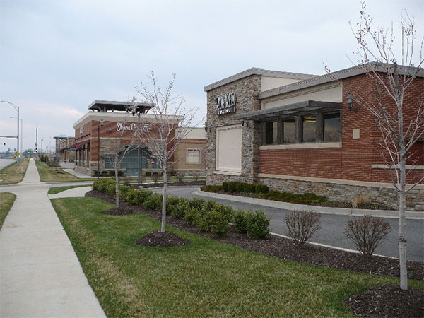
Restaurant Drive-through is screened from the sidewalk and the street. |
Effective on: 1/1/1901
SDS 5.7 Site Amenities
| Commercial | |||||||
| CP-0 | C-0 | CP-1 | C-1 | CP-2 | C-2 | CP-3 | C-3 |
SDS 5.7.1 Intent.
Site amenities offer convenient and inviting features for residents to use; these amenities help to make a common open space feel comfortable and usable.
Standard:
SDS 5.7.2 Required Amenities.
According to the Comprehensive Plan Development Classification, development sites of at least three (3) acres shall provide the following amenities.
| Comprehensive Plan Development Classification | Required Number of Amenities | Allowed Amenities | |
|---|---|---|---|
| No Specific Classification | Less than 25,000 s.f. | None |
|
| At least 25,000 s.f. | 2 | ||
| Neighborhood Center | At least 25,000 s.f.; less than 150,000 s.f. | 3 | |
| Community Center | At least 150,000 s.f.; less than 400,000 s.f. | 4 | |
| Regional Center | At least 400,000 s.f.; | 5 | |
SDS 5.7.3 Design Requirements.
- All site amenities within a commercial development shall be an integral part of the overall design and within easy walking distance of major buildings, major tenants, and any transit stops.
- Any such amenity/area shall have direct access to the public sidewalk network.
- The amenity/area shall be constructed of materials that are similar in quality to the principal materials of the primary buildings and landscape.
SDS 5.7.4 Site Amenities as Focal Points.
A site amenity may qualify as a focal point required above provided the site amenity meets all applicable requirements for focal points. (See Section SDS 5.2).
SDS 5.7.5 Site Amenities as Transitions.
A site amenity may qualify as a transition provided the site amenity meets all applicable requirements for transitions. (See Section SDS 5.1).
| Site Amenity Examples | |
|---|---|
.jpg)
Square |
|
.jpg)
Patio with Seating |
(1).jpg)
Clock Tower |
.jpg)
Public Art |
(1).jpg)
Water Feature |
Effective on: 1/1/1901
SDS 5.8 Walkways Along Buildings & Parking Areas
| Commercial | |||||||
| CP-0 | C-0 | CP-1 | C-1 | CP-2 | C-2 | CP-3 | C-3 |
SDS 5.8.1 Intent.
Pedestrian walkways along the edge of a commercial building shall ensure adequate width for customers and landscaping.
Standard:
SDS 5.8.2 Walkways along Buildings.
Pedestrian walkways shall be provided along the full length of a primary building along any façade featuring a customer entrance and along any façade abutting customer parking areas.
SDS 5.8.3 Landscaping along Walkways.
Landscaping along the pedestrian walkways shall be provided in at least one of the following ways:
- Option 1: Planting Beds between the building facade and the walkway, except where features such as arcades or entryways are part of the facade.
- Option 2: Shade Trees planted in tree wells or tree planters located between the walkway and street, drive, or parking area.
SDS 5.8.4 Dimensions & Landscaping.
Dimensions and landscaping for these walkways shall comply with the following table.
| For Option 1 or Option 2: | For Option 1: | For Option 2: | |
|---|---|---|---|
| Walkway is located: | Clear Walkway Width | Planting Bed Width | Tree Well or Tree Planter Width |
| Along a Primary Building | 8’ min | 6’ min | 5’ min |
| Along a Pad Site Building | 5’ min | 3’ min | 5’ min |
SDS 5.8.5 Walkways Through Vehicle Areas.
At each point that the on-site pedestrian walkway system crosses a parking lot or internal street or driveway, the walkway or crosswalk shall be clearly marked through the use of a change in paving materials distinguished by their color, texture, or height.
SDS 5.8.6 Arcade or Gallery Widths.
The width of an arcade or gallery shall be at least eight (8) feet.
SDS 5.8.7 Seating Areas.
Seating areas along a pedestrian walkway shall allow at least six (6) feet of clear sidewalk width for pedestrian passing.
| Landscaping along Walkways Examples | |
|---|---|
|
Option 1. Planting Beds
.jpg)
|
Option 2. Shade Trees
|
|
|
|
(2).jpg)
(1).jpg)
(1).jpg)
Effective on: 1/1/1901
SDS 5.9 Street Connections: Commercial
| Commercial | |||||||
| CP-0 | C-0 | CP-1 | C-1 | CP-2 | C-2 | CP-3 | C-3 |
SDS 5.9.1 Intent.
Streets shall be interconnected to provide numerous paths for both pedestrian and vehicular travel; numerous street connections also provide better emergency access.
SDS 5.9.2 Standard.
The internal street system shall connect to the public street system to provide multiple direct connections to and between local destinations such as parks, schools, and shopping.
SDS 5.9.3 Interconnectivity.
The internal street system shall connect to the perimeter public street system to provide for both intra- and inter-neighborhood connections to knit separate developments together, rather than forming barriers between them. Accordingly, the internal street system shall provide vehicle connections, other than primary vehicle access, to each adjoining residential or collector streets. Where possible, developments greater than five (5) acres shall include a minimum of one (1) “through-street,” The through-access street shall be continuous through the site, and connect to a perimeter public street. The design of all through-access streets shall be consistent with, and aligned with, residential drives or through-access drives in adjacent existing or planned development sites.
SDS 5.9.4 Future Street Connections.
Except as in cul-de-sacs above, dead-end streets shall not be permitted except in cases when the street is designed to connect with future streets on adjacent land.
SDS 5.9.5 Connections to Adjacent Non-Residential Uses.
Connections between adjacent non- residential development parcels shall be provided by siting a logical array of access points continuous to the adjacent development. Common or shared service and delivery access shall be provided between adjacent parcels and/or buildings. Exceptions may be made in cases where physical constraints dictate that no other option is possible. The city may require access easements to ensure that pad sites or adjacent parcels have adequate access if ownership patterns change.
SDS 5.9.6 Connections to Adjacent Residential Uses.
Unless no other alternative can be reasonably provided, commercial drives or on-site streets shall not align with access to adjacent residential developments.
Effective on: 1/1/1901
SDS 5.10 Vehicle Access & Circulation: Commercial
| Commercial | |||||||
| CP-0 | C-0 | CP-1 | C-1 | CP-2 | C-2 | CP-3 | C-3 |
SDS 5.10.1 Intent.
Vehicle access and circulation in commercial developments shall create an interconnected street network, provide safe vehicular and pedestrian environments, and orient streets to define and protect important views.
Standard:
SDS 5.10.2 Primary Vehicle Access.
- Primary access to Large Commercial Centers shall be from the thoroughfare street system. In order to maximize the efficiency of the city’s street network, major traffic generators should be located so that their primary access is from a thoroughfare or commercial access road.
- Large Commercial Centers should be located at the intersection of thoroughfare streets so that access is available for both east/west and north/south traffic. Primary access points should be located so that commercial traffic is separated from the residential street system.
- If a Large Commercial Center is proposed at a location or density that will have a significant effect on current traffic patterns, a traffic impact study may be required to ensure that the street network can accommodate the anticipated traffic demands and to define required street improvements.
SDS 5.10.3 Internal Vehicle Circulation.
- Internal vehicle circulation patterns shall provide a clear and direct path to the principal customer entrance of the primary building, to outlying pad sites, and to each parking area.
- In Large Commercial Centers, a clear system of main circulation drives containing few or no parking spaces that directly access the main drives shall be established to carry the highest volumes of traffic within the site.
- In order to reduce pedestrian and vehicular conflicts, those main circulation drives shall not be located along the façades of buildings that contain primary customer entrances. In areas where the location of access points and the configuration of the main circulation drives indicate that traffic volumes will not be excessive, drives may contain directly-accessing parking spaces and may be located along façades containing primary customer entrances.
- When possible, the intersection of two main circulation drives shall be designed as a “t” intersection, rather than a four-legged intersection, to minimize vehicular conflicts.
SDS 5.10.4 Commercial Centers No Larger Than 100,000 s.f..
Commercial centers no larger than 100,000 square feet shall comply with the following:
- Centers where traffic volumes are lower and, consequently, pedestrian-vehicular and vehicular-vehicular conflicts are less likely, more flexibility is available in the location and design of internal drives.
- Because of the lower traffic volumes, entry drive throat lengths can be shorter.
- The use of four-legged intersections can be utilized more extensively.
- Depending on the size of the shopping center and the number and location of access points, fewer restrictions may be placed on the extent to which traffic entering the site is directed to the drives along the building façades.
- Main drive aisles shall be continuous and connect to the main entrance to the development site.
- Internal intersections shall have adequate sight lines, design geometrics, and/or traffic controls to minimize accident potential.
Effective on: 1/1/1901
SDS 5.11 Vehicle Entrances
| Commercial | |||||||
| CP-0 | C-0 | CP-1 | C-1 | CP-2 | C-2 | CP-3 | C-3 |
SDS 5.11.1 Intent.
Vehicle entrances to commercial development shall be designed to ensure both pedestrian and vehicular safety.
Standard:
SDS 5.11.2 Primary Vehicle Entrances.
The number and location of vehicle entrances to a commercial development shall be consistent with the existing or anticipated design of adjacent streets. The specific location of primary vehicle entrances are subject to the approval of the Planning and Development Services Department and will be largely dependent on the following factors:
- The location of existing or planned median breaks.
- Separation requirements between the entrance and major intersections.
- Separation requirements between adjacent entrances (or minor intersections).
- The need to provide shared access to adjacent parcels of land.
- The need to align with previously-approved or constructed access points on the opposite side of the street.
- The minimum number of entrances needed to move traffic onto and off the site safely and efficiently.
SDS 5.11.3 Entry Drive Configuration.
The specific design or geometrics of development entry drives shall conform to the standards of the Planning and Development Services Department. Commercial driveway configuration and design shall be appropriate given the size of the development and the capacity of the street.
SDS 5.11.4 Driveway Design.
Driveway geometrics shall be dependent on a variety of factors, including traffic volume, speed, vehicle types requiring site access, and distribution. The following design issues should be addressed in each case and the resulting driveway design should provide an efficient ingress and egress to the development without causing undue congestion or accidents (non-vehicular and vehicular) on the public street system:
- The number of in-bound and out-bound lanes.
- Lane width (minimum width curb-to-curb is 28 feet).
- Throat length (i.e., the distance between the street and the first point at which cross traffic or left turns are permitted).
- Curb radii.
- The need or desirability of a raised median.
- The need for a deceleration lane.
- Accommodation for pedestrian crossings.
- Curb cuts must be located to minimize conflicts with pedestrians and bicyclists and must have a clear distance from fire hydrants, street trees, utility poles, and other furnishings as deemed necessary.
- The grade, cross slope, and clear width of the walkway of a sidewalk traversing a driveway must be maintained between the driveway apron and the abutting driveway. The appearance of the walkway (i.e. scoring pattern or paving material) must indicate that, although a vehicle may cross, the area traversed by a vehicle remains part of the sidewalk.
Effective on: 1/1/1901
SDS 5.12 Service Access & Circulation
| Commercial | |||||||
| CP-0 | C-0 | CP-1 | C-1 | CP-2 | C-2 | CP-3 | C-3 |
SDS 5.12.1 Intent.
Service access and circulation to commercial developments shall be designed to allow use by both emergency and service vehicles.
Standard:
SDS 5.12.2 On-Site Truck Traffic/Loading and Circulation.
- Every shopping center will be required to provide loading and delivery facilities separate from customer parking and pedestrian areas.
- Due to their greater size and lower maneuverability, truck circulation paths should be designed with larger curve radii and more maneuvering room.
- As the size of the development and the volume of trucks increase, internal circulation patterns should reflect an increasing separation between automobile and truck traffic in order to minimize accidents and congestion.
SDS 5.12.3 Emergency Access.
All commercial developments shall comply with the currently-adopted code provisions regarding emergency vehicle access and fire lanes.
Effective on: 1/1/1901
SDS 5.13 Parking Location & Layout: Commercial
| Commercial | |||||||
| CP-0 | C-0 | CP-1 | C-1 | CP-2 | C-2 | CP-3 | C-3 |
SDS 5.13.1 Intent.
The typical suburban commercial development pattern of locating large amounts of parking between the fronts of buildings and adjacent streets contributes to a bleak and formless landscape. Locating parking along the side and rear of the buildings reduces the size of street-facing parking lots.
Standard:
SDS 5.13.2 Location.
No more than three (3) off-street parking spaces per 1000 square feet of all uses contained in the development’s primary building shall be located between the front façade of the primary building and the primary abutting street. If the development does not meet this standard, the total amount of surface parking area shall be broken up into parking blocks containing no more than 25 spaces and shall comply with the methods in Section SDS 5.13. Alternative provisions shall be considered when the commercial development abuts an existing residential neighborhood.
SDS 5.13.3 Orientation.
When possible, parking shall be oriented to minimize visual and noise impacts on adjacent residential properties.
SDS 5.13.4 Parking Blocks.
The total amount of surface parking shall be broken up into parking blocks containing no more than 40 spaces each and shall comply with the following.
- Parking blocks shall be separated from each other by landscaping, medians, islands, pedestrian walkways, or buildings. Refer to Parking Lot Landscaping.
- Each parking block shall have consistent design angles for all parking within the block.
- Parking blocks shall be oriented to buildings to allow pedestrian movement down and not across rows (typically with parking drive aisles perpendicular to customer entrances).
- Through-access shall be provided within and between parking blocks.
- Where parking blocks are not easily defined, there shall be no more than ten (10) parking spaces without an intervening landscape island at least nine (9) feet wide.
SDS 5.13.5 Shopping Cart Return Areas.
As applicable, shopping cart return stations shall be evenly distributed within and between separate parking blocks. Shopping cart return stations shall be identified on the final plan.
| Parking Block | Parking between Building and Street |
|---|---|
|
|
|
.jpg)
.jpg)
Effective on: 1/1/1901
SDS 6.1 Lot Width, Depth, & Orientation
| Single Family | Multi-Family | |||||||||||
| RP-1N | RP-1A | R-1A | RP-1 | R-1 | RP-2 | R-2 | RP-3 | R-3 | RP-4 | RP-5 | RP-6 | |
SDS 6.1.1 Required Lot Width & Depth.
Lot width and depth are regulated by the UDO. For reference, UDO section numbers are given in the following table.
| Required Lot Width and Depth | ||
| Applies for all Development (Includes Redevelopment & Infill Development) | Applies Only to Redevelopment & Infill Development | |
| Zoning District | By UDO Section: | |
| R-1, RP-1 | 18.180.030 |
The average lot width of new parcels created by subdivision or lot split shall be no less than 80% of the average width of existing lots on the same and facing block faces, but shall not be required to be greater than 120 feet and may not be less than the minimum required by the UDO. |
| R-1A, RP-1A | 18.190.030 | |
| RP-1N | 18.195.030 | |
| R-2, RP-2 | 18.200.030 | |
| PRN | 18.245.030 | |
| R-3, RP-3 | No applicable standard | |
| RP-4 | ||
| RP-5 | ||
| RP-6 | ||
SDS 6.1.2 Lot Orientation.
The orientation of new lots created by subdivision or lot split shall repeat the predominate relationship of buildings-to-buildings and buildings-to-street along the same and facing block faces.
Effective on: 1/1/1901
SDS 6.2 Maximum Density
| Multi-Family | ||||||
| RP-2 | R-2 | RP-3 | R-3 | RP-4 | RP-5 | RP-6 |
SDS 6.2.1 Allowed Maximum Density.
Maximum density is regulated by the UDO and this document according to the following table.
| Allowed Maximum Density (Dwelling Units/Acre) |
|||||
|---|---|---|---|---|---|
| Infill & Redevelopment | All Other Development | ||||
| Zoning District | UDO Reference | With No Incentive Bonuses | With Incentive Bonuses | With No Incentive Bonuses | With Incentive Bonuses |
| R-2, RP-2 | 18.200.030 | 10.9 | 13.63 | 5 | 7.26 |
| R-3, RP-3 | 18.210.030 | 12.4 | 15.50 | 9 | 12.4 |
| RP-4 | 18.220.030 | 7.26 | 9.08 | 5 | 7.26 |
| RP-5 | 18.230.030 | 16.4 | 20.63 | 14 | 16.4 |
| RP-6 | 18.240.030 | 43.6 | 54.50 | 29 | 43.0 |
SDS 6.2.2 Density.
The number of dwelling units per net site area.
SDS 6.2.3 Net Site Area, UDO 18.110.435.
Net site area means the land area of a lot or tract remaining after subtraction of all street and alley right-of-way as required by the UDO.
Effective on: 1/1/1901
SDS 6.3 Lot Coverage
| Multi-Family | ||||||
| RP-2 | R-2 | RP-3 | R-3 | RP-4 | RP-5 | RP-6 |
SDS 6.3.1 Maximum Lot Coverage.
Lot coverage is regulated by the UDO. For reference, UDO section numbers are given in the following table.
| Zoning District | UDO Reference | Maximum Lot Coverage |
|---|---|---|
| R-2, RP-2 | 18.200 | 50% |
| R-3, RP-3 | 18.210.050 | |
| RP-4 | 18.220 | 60% |
| RP-5 | 18.230.050 | |
| RP-6 | 18.240.050 | 70% |
SDS 6.3.2 Lot Coverage, UDO 18.110.380.
Lot coverage means that portion of the net site area which is covered by the ground floor of any structure, parking lots, and private streets and drives. Pools, tennis courts, sidewalks, and plazas are not counted toward lot coverage.
SDS 6.3.3 Net Site Area, UDO 18.110.435.
Net site area means the land area of a lot or tract remaining after subtraction of all street and alley right-of-way as required by the UDO.
Effective on: 1/1/1901
SDS 6.4 Building Orientation
| Single Family | Multi-Family | ||||||
| RP-2 | R-2 | RP-3 | R-3 | RP-4 | RP-5 | RP-6 | |
SDS 6.4.1 Intent.
Buildings shall be arranged in the landscape to define streetscapes and designed open space. This enclosure promotes walkability, usability, and slower vehicle speeds.
Standard:
SDS 6.4.2 Building Orientation.
Each primary building shall be oriented to have at least one building front.
- Building Front. A building front shall be a building wall that faces a public street, a private street, a common open space; a building can have more than one building front.
- Building Back. A building back shall be a building wall that does not face a public street, a private accessway, or a common open space; a building can have more than one building back.
SDS 6.4.3 Building Orientation to Street Edges.
Multiple buildings may line up parallel to a public street if the following conditions are met:
- Each individual building has a facade classified as a building front facing the perimeter street.
- Individual building length along the street frontage is no greater than 125 feet.
- Common open space is centrally located in the site and accessible by all development residents.
SDS 6.4.4 Buildings Adjacent to Lower-Density Residential Uses or Non-Residential Uses.
Along interior (non-street edge) property lines, buildings shall be oriented in a perpendicular rather than parallel direction to adjacent lower-density residential zoning districts or uses and to adjacent commercial or industrial zoning districts or uses. When parallel orientation is necessary, building setback from the adjacent use or district boundary shall be increased by at least 50%.
SDS 6.4.5 Building Orientation and Pedestrian Access
All building fronts must provide pedestrian access to the adjacent public street, private street, or common open space.
| Building Orientation | |
|---|---|
|
Buildings Face a Common Open Space:
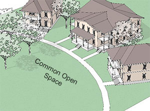
|
Buildings Face a Public Street or a Private Accessway
.jpg)
|
Effective on: 1/1/1901
SDS 6.5 Common Open Space: Area & Type
| Single Family | Multi-Family | ||||||
| RP-2 | R-2 | RP-3 | R-3 | RP-4 | RP-5 | RP-6 | |
SDS 6.5.1 Intent.
Creating areas of common open space that are easily accessed by residents provides centers for community recreation and interaction. Successful common open spaces exhibit the qualities of either a green, a courtyard, or a small nature preserve. Common open spaces shall be either preserved to protect its natural qualities or designed to be more actively used by residents.
Standard:
SDS 6.5.2 Types.
All common open spaces shall be classified as one of the two following types:
- Natural Open Space is common open space that is in its natural, preserved, or restored state of natural woodland, grassland, or wetland. Typical amenities provided are limited to items such as paths and benches. The area of a pond or lake shall be classified as natural open space.
- Designed Open Space is common open space that is created and designed for year-round use by residents or the public. Typical configurations include greens, squares, courtyards, and gardens. Amenities are logically arranged and typically include benches, paths, formal or informal planting areas, lawns, and play equipment. Designed open space shall be aggregated into meaningful, quality open spaces. Clustering of buildings around designed open space is encouraged to minimize small, narrow, unassigned strips in front of and between buildings. Detention and retention facilities, including drainage swales and rain gardens, shall be classified as designed open space provided they are designed to meet and do not impede the goals, typical configurations, and typical amenities of designed open space.
SDS 6.5.3 Designation.
Common open space areas shall be clearly identified on the development plan as Natural Open Space or Designed Open Space.
SDS 6.5.4 Required Common Open Space Area.
Developments shall set aside a percentage of the net site acreage as common open space for the use and enjoyment of the development’s residents according to the following table.
| Required Common Open Space Area | |||
|---|---|---|---|
| Zoning District | UDO Reference | Net Site Area is: | |
| Not Greater Than 3 Acres | Greater Than 3 Acres | ||
| R-2, RP-2 | N/A | No Applicable Standard | |
| R-3, RP-3 | 18.210.050 | No Min. | 10% min. |
| RP-4 | 18.220.050 | ||
| RP-5 | 18.230.040 | ||
| RP-6 | 18.240.040 | ||
| PRN | 18.245.050 | No Min. | 15% min. |
SDS 6.5.5 Required Designed Open Space Area.
At least half of the required common open space shall be designed open space. Designed open space also counts as part of the required common open space area.
SDS 6.5.6 Detention and Retention Facilities.
Detention and retention facilities, including drainage swales, rain gardens, lakes, and ponds may be used to meet up to 100% of the required common open space provided such areas can be classified as designed open space or natural open space.
SDS 6.5.7 Exemptions.
No common open space shall be required for developments of less than five (5) acres if at least one of the following is located within a 1/4 mile of the development:
- Dedicated Public Park or Greenway Lands
- Dedicated Open Spaces
| Common Open Space: Area & Type | |
|---|---|
|
Woodland: a natural open space |
Courtyard: a designed open space |
|
Neighborhood Green: a designed open space |
|
.jpg)
.jpg)
.jpg)
Effective on: 1/1/1901
SDS 6.6 Designed Open Space: Shape & Content
| Single Family | Multi-Family | ||||||
| RP-2 | R-2 | RP-3 | R-3 | RP-4 | RP-5 | RP-6 | |
SDS 6.6.1 Intent.
Given its environmental and recreational benefits, designed open space shall be integrated into the overall design of the development; designed open space shall not be left-over areas of the site that simply were not used for parking lots and buildings.
Standard:
SDS 6.6.2 Compact and Contiguous.
Designed open space shall be compact and contiguous unless the designed open space is used as a continuation of an existing greenway, streamway, or park.
SDS 6.6.3 Areas not Allowed as Part of Designed Open Space.
The following areas shall not be counted as designed open space.
- Private lots, yards, balconies and patios dedicated for use by a specific unit.
- Public right-of-way or private streets.
- Open parking areas and driveways for dwellings.
- Land covered by structures except for ancillary structures associated with the use of the open space such as gazebos, picnic shelters, and other site amenities.
- Designated outdoor storage areas.
- Land areas between buildings of less than 40 feet that do not provide a sidewalk link between two larger open space areas.
- Land areas between buildings and parking lots, driveways, streets, or drives of less than 40 feet.
- Land areas of less than 40 feet in distance between a building and the minimum allowed setback from a street.
- Land areas of less than 40 feet in distance between a building and the minimum allowed setback from any adjacent property used for other purposes than open space.
- Detention/retention facilities, including drainage swales and rain gardens, that can not be classified as designed open space.
SDS 6.6.4 Fences/Walls.
Opaque fences and walls higher than three (3) feet shall not be erected in private or rear yards bordered by common open space unless they are at least 50% transparent.
| Designed Open Space: Shape & Content | ||||
|---|---|---|---|---|
|
||||
|
||||
|
||||
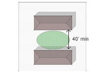
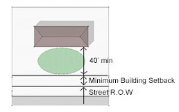
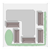
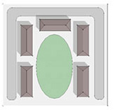
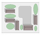
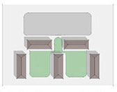
Effective on: 1/1/1901
SDS 6.7 Common Open Space: Accessibility
| Single Family | Multi-Family | ||||||
| RP-2 | R-2 | RP-3 | R-3 | RP-4 | RP-5 | RP-6 | |
SDS 6.7.1 Intent.
Successful common open space is easily accessible to residents; connections to adjacent or nearby parks and centers of human activity help to promote its usability.
Standard:
SDS 6.7.2 Accessible to Residents.
Common open space shall be reasonably accessible to all of the residents of the development and conform to the following:
- Pedestrian access to common open space shall occur at least once every 500 feet of linear length of common open space.
- Pedestrian access to common open space shall occur within 500 feet of every dwelling unit in the development.
- The city may require access to be restricted if it would degrade, destroy, or adversely interfere with significant environmental, natural, historic, or cultural resources and areas.
- Access to common open space shall be located where such access is visible to dwelling units and shall not be isolated by walls, screening, landscaping, or any other kind of barrier that would prevent resident surveillance of the common open space.
SDS 6.7.3 Connectivity.
If adjacent to the development, the following shall be connected by path, sidewalk, or trail to the common open space:
- Dedicated public park or greenway lands.
- Dedicated school sites.
- Dedicated open spaces.
- Common open space located adjacent to the development.
- Portions of the regional trail and open space system.
- Neighborhood shopping and activity centers.
- Adjacent employment centers.
SDS 6.7.4 Greenway Linkages.
Where a greenway linkage, natural area, or other public park is dedicated to or acquired by the city as part of the Greenway Linkages Plan, such area may be credited toward the minimum amount of common open space required. These areas may also qualify for applicable density bonuses.
Effective on: 1/1/1901
SDS 6.8 Site Amenities: Developments of at least 3 Acres
| Single Family | Multi-Family | ||||||
| RP-2 | R-2 | RP-3 | R-3 | RP-4 | RP-5 | RP-6 | |
SDS 6.8.1 Intent.
Site amenities offer convenient and inviting features for residents to use; these amenities help to make a common open space feel comfortable and usable.
SDS 6.8.2 Standard.
The required number of amenities is determined by the total number of units according to the following tables.
| Total Number of Dwelling Units | Required Number of Minor Amenities | Required Number of Major Amenities |
|---|---|---|
| Less that 50 | 2 min. | No min. |
| At least 50; No more than 200 | 3 min. | 1 min. |
| More than 200 | 4 min. | 2 min. |
| Minor Amenities | Major Amenities |
|---|---|
| Tot Lot including play equipment for children; 500 s.f. min | Swimming Pool |
| Picnic Area including at least two (2) picnic tables and at least one (1) barbecue grill/pit; 500 s.f. min | Golf Course |
| Residential Club House | |
| Pedestrian and/or bike path serving open space | Basketball, Volleyball, Tennis, or other sporting court; only one (1) sporting court shall count towards the major amenity requirement |
Effective on: 1/1/1901
SDS 6.9 Site Amenities: Developments of Less than 3 Acres
| Single Family | Multi-Family | ||||||
| RP-2 | R-2 | RP-3 | R-3 | RP-4 | RP-5 | RP-6 | |
SDS 6.9.1 Intent.
Site amenities offer convenient and inviting features for residents to use; these amenities help to make a common open space feel comfortable and usable.
SDS 6.9.2 Standard.
At least three (3) of the following site amenities are required for developments of less than three (3) acres.
- Seasonal Planting Areas;
- Flowering Trees in addition to required trees;
- Seating;
- Pedestrian-Scaled Lighting;
- Gazebo or other Decorative Shelter;
- Play Structures for Children;
- Natural Woodland, Grassland, or Wetland;
- Pond.
| Site Amenity Examples | |
|---|---|
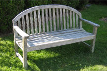
Seating |
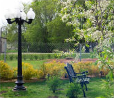
Seating and pedestrian-scaled lighting |
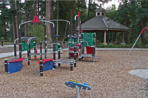
Play structures for children |
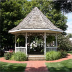
Gazebo |
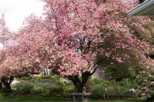
Flowering Tree |
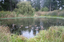
Water Feature |
Effective on: 1/1/1901
SDS 6.10 Street Connections: Multi-Family
| Multi-Family | ||||||
| RP-2 | R-2 | RP-3 | R-3 | RP-4 | RP-5 | RP-6 |
SDS 6.10.1 Intent.
Streets shall be interconnected to provide numerous paths for both pedestrian and vehicular travel; numerous street connections also provide better emergency access.
Standard:
SDS 6.10.2 Applicablity.
This standard shall be applicable in R-2, RP-2, R-3, RP-3, RP-4, RP-5, and RP-6 zoning districts.
SDS 6.10.3 General.
The internal street system shall connect to the public street system to provide multiple direct connections to and between local destinations such as parks, schools, and shopping.
SDS 6.10.4 Interconnectivity.
The internal street system shall connect to the perimeter public street system to provide for both intra- and inter-neighborhood connections to knit separate developments together, rather than forming barriers between them. Accordingly, the internal street system shall provide vehicle connections, other than primary vehicle access, to each adjoining residential or collector streets. Where possible, developments greater than five (5) acres shall include a minimum of one “through-street”. The through-access street shall be continuous through the site, and connect to a perimeter public street. The design of all through-access streets shall be consistent with, and aligned with, residential drives or through-access drives in adjacent existing or planned development sites.
SDS 6.10.5 Future Street Connections.
Dead-end streets shall not be permitted except in cases when the street is designed to connect with future streets on adjacent land.
Effective on: 1/1/1901
SDS 6.11 Street Connections: Planned Single-Family
| Single Family | |||||
| RP-1N | RP-1A | RP-1 | |||
SDS 6.11.1 Intent.
Streets shall be interconnected to provide numerous paths for both pedestrian and vehicular travel; numerous street connections also provide better emergency access.
Standard:
SDS 6.11.2 Applicability.
This standard shall be applicable in RP-1, RP-1A, RP-1N, and PRN zoning districts.
SDS 6.11.3 General.
The internal street system shall connect to the public street system to provide multiple direct connections to and between local destinations such as parks, schools, and shopping.
SDS 6.11.4 Interconnectivity.
The internal street system shall connect to the perimeter public street system to provide for both intra- and inter-neighborhood connections to knit separate developments together, rather than forming barriers between them. Where possible, developments greater than five (5) acres shall include a minimum of one “through-street”. The through-access street shall be continuous through the site, and connect to a perimeter public street. The design of all through- access streets shall be consistent with and aligned with, or sufficiently offset from, residential drives or through-access drives in adjacent existing or planned development sites.
SDS 6.11.5 Cul-de-sacs.
The use of cul-de-sacs in place of complete through-street connections is strongly discouraged. Only when natural features such as topography, drainage ways, or stream corridors preclude street connections may cul-de-sacs be used. Cul-de-sacs shall be limited to 500 feet in length.
SDS 6.11.6 Future Street Connections.
Except as in cul-de-sacs above, dead-end streets shall not be permitted except in cases when the street is designed to connect with future streets on adjacent land.
SDS 6.11.7 Street Width.
Streets may be 26 feet wide except in the following areas:
-
1.Along street frontages of community facilities (i.e.- schools, clubhouses, pools) and along a route from the community facility to the nearest collector street or thoroughfare. The specific streets that will need to be 28 feet wide to meet this requirement will be determined by Overland Park Fire Department at the time of the rezoning.
-
2.Where a street or series of streets is provided only a single point of access to the adjoining public street network. Streets that stub into abutting property may be 26 feet wide if the Planning and Development Services Department and Overland Park Fire Department determine that the extension of that stub is likely to connect to another point of access on the public street system.
-
3.At the point where a local residential street connects to a thoroughfare.
-
4.Residential streets where alleys occur and there are a limited or no driveways along the public street.
-
5.A street that is designated as a collector on the City’s Comprehensive Plan.
SDS 6.11.8 Block Size.
Block size shall be regulated by block perimeter and intersection distance according to the following table.
| District | Maximum Block Perimeter | Maximum Intersection Distance |
|---|---|---|
| RP-1, RP-1A, RP-1N, PRN | 3000’ | 800’ |
SDS 6.11.9 Block Perimeter.
Block perimeter shall be the perimeter distance of a block; block perimeter shall be measured at the lot line around blocks. For blocks that abut a boundary to the development, the boundary line shall be considered an edge to the block.
SDS 6.11.10 Intersection Distance.
Intersection distance shall be the distance between two consecutive street and/or private accessway intersections; intersection distance shall be measured between the centerlines. Alleys and driveways shall not be considered streets or private accessways for the purposes of this standard.
| Street Connections: Planned Single-Family | |
|---|---|
| Block Perimeter Example | Intersection Distance Example |
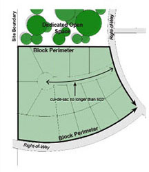 |
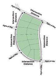 |
|
Right-of-Way shall refer to a street or private accessway.
|
|
Effective on: 1/1/1901
SDS 6.12 Street Connections: Unplanned Single-Family
| Single Family | |||||
| R-1A | |||||
SDS 6.12.1 Intent.
Streets shall be interconnected to provide numerous paths for both pedestrian and vehicular travel; numerous street connections also provide better emergency access.
Standard:
SDS 6.12.2 Applicability.
This standard shall be applicable in R-1 and R-1A zoning districts.
SDS 6.12.3
The internal street system shall connect to the public street system to provide multiple direct connections to and between local destinations such as parks, schools, and shopping.
SDS 6.12.4 Interconnectivity.
The internal street system shall connect to the perimeter public street system to provide for both intra- and inter-neighborhood connections to knit separate developments together, rather than forming barriers between them. Where possible, developments greater than five (5) acres shall include a minimum of one “through-street”. The through-access street shall be continuous through the site, and connect to a perimeter public street. The design of all through- access streets shall be consistent with, and aligned with, or sufficiently offset from, residential drives or through-access drives in adjacent existing or planned development sites.
SDS 6.12.5 Cul-de-sacs.
When a cul-de-sac is used, it should not exceed 1000 feet in length. Cul-de- sacs may exceed this length due to topography, drainage ways, or other natural features that would preclude a street connection from occurring.
SDS 6.12.6 Future Street Connections.
Except as in cul-de-sacs above, dead-end streets shall not be permitted except in cases when the street is designed to connect with future streets on adjacent land.
| Street Connections: Unplanned Single-Family | |
|---|---|
| Don't Do This: | |
|
Many of these cul-de-sacs are longer than 1000 feet and are so numerous that the street network has few connections. |
Due to limited connectivity, this long cul-de-sac is discouraged. |
| Do This: | |
|
This internal street network has good connectivity both within the development and to the surrounding neighborhood. |
This street network radiates out from a central square and provides superior connectivity. |
|
Downtown Overland Park's streets are well connected. |
This Overland Park neighborhood provides an example of good connectivity. |
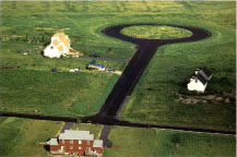
Effective on: 1/1/1901
SDS 6.13 Private Drives & Accessways
| Single Family | Multi-Family | ||||||
| RP-2 | R-2 | RP-3 | R-3 | RP-4 | RP-5 | RP-6 | |
SDS 6.13.1 Intent.
Streets, drives, or accessways shall be sized according to their use and whether parking is allowed on the roadway.
Standard:
SDS 6.13.2 Dimensional Standards.
The dimensions and standards for all streets, drives, and accessways shall meet the specifications listed in this standard and the Municipal Code.
SDS 6.13.3 Roadway Submittal.
Applications shall include dimensional standards for its streets, drives, and accessways and shall indicate their location on a plan of the development.
| Parallel Parking | ||||
|---|---|---|---|---|
| Roadway Type | Roadway Width | Both Sides of the Roadway | One Side of the Roadway | Parking is Not Allowed on the Roadway |
| 36’ Drive | 36’ | X | ||
| 28’ Drive | 28’ | X | ||
| 24’ Drive | 24’ | X | ||
SDS 6.13.4 36’ Drive:
The 36’ Drive is a roadway type that would be compatible for use in multi-family developments desiring to provide parallel parking on both sides of the roadway.
| 36’ Drive |
|---|
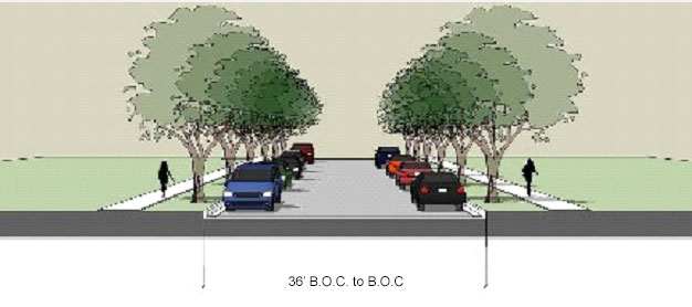 |
SDS 6.13.5 28’ Drive:
The 28’ Drive is a roadway type that would be compatible for use in multi-family developments desiring to provide parallel parking on one side of the roadway.
| 28’ Drive |
|---|
.jpg) |
SDS 6.13.6 24’ Drive:
The 24’ Drive is a roadway type that would be compatible for use in multi-family developments desiring to provide no parking along the roadway.
| 24’ Drive |
|---|
.jpg) |
Effective on: 1/1/1901
SDS 6.14 Vehicle Access & Circulation: Residential
| Single Family | Multi-Family | |||||||||||
| RP-1N | RP-1A | R-1A | RP-1 | R-1 | RP-2 | R-2 | RP-3 | R-3 | RP-4 | RP-5 | RP-6 | |
SDS 6.14.1 Intent.
Vehicle access and circulation in residential developments shall create an interconnected street network, provide safe vehicular and pedestrian environments, and orient streets to define and protect important views.
SDS 6.14.2 Standard.
Vehicle access to and within the interior of the development shall be provided by either public streets or by private accessways. The internal street system should be arranged to utilize both parallel and perpendicular streets in identifiable blocks or clusters; curvilinear or diagonal streets are allowed. “T” intersections are encouraged in locations where views of important public spaces or natural or open areas can be highlighted.
SDS 6.14.3 Standard.
Residential developments shall have sufficient emergency access and multiple primary access points as follows:
- Multi-family residential projects having more than 200 dwelling units shall be provided with two separate and approved fire apparatus access roads.
- One- and two-family residential developments with fifty or more dwellings shall be provided with two separate and approved fire apparatus access roads.
- Additional access or on-street parking restrictions above that in this document may be required by the Fire Department.
Effective on: 1/1/1901
SDS 6.15 Parking Location & Layout: Residential
| Single Family | Multi-Family | ||||||
| RP-2 | R-2 | RP-3 | R-3 | RP-4 | RP-5 | RP-6 | |
SDS 6.15.1 Intent.
The visual impact of parking lots, parking structures, and garages from streets shall be minimized.
Standard:
SDS 6.15.2 Location.
- Off-street parking is prohibited between a building front of a primary building and a street or common open space.
- When possible, parking areas and parking structures shall be internalized in building groupings or oriented away from streets.
SDS 6.15.3 Parking Setbacks.
- See UDO 18.430.
SDS 6.15.4 Parking Blocks.
There shall be no more than 10 parking spaces without an intervening landscape island at least 9 feet wide. This block of 10 or less parking spaces shall be defined as a parking block for residential districts.
SDS 6.15.5 Detached Garages and Carports
- Detached garages and carports shall only be permitted in the interior of the property and not adjacent to the street; when it is necessary to site a detached garage and carport in a location that is visible from perimeter public streets, they shall be sited perpendicular to the perimeter public street.
- Storage areas are only permitted in detached garages and carports that are fully enclosed.
SDS 6.15.6 Attached Garages
- When possible, the driveway leading to each individual unit’s garage shall not exceed a grade of 7%.
- Garage Setback. To allow sufficient area for vehicles to be parked without interfering with internal circulation, the length of the driveway between the garage door and the sidewalk shall be at least 18 feet or shall be no greater than 5 feet. If there is no sidewalk, the length of the driveway between the garage door and the back-of-curb or roadway shall be at least 18 feet or shall be no greater than 5 feet.
SDS 6.15.7 Below-Grade Parking Access
- Access to below-grade parking shall not be located on a building front.
- Where access on a public front is necessary, the access drive shall not be wider than 24 feet.
| Parking Location & Layout: Residential |
|---|
|
Parking Block
|
|
Garage Setback with Sidewalks
|
|
Garage Setback without Sidewalks
|
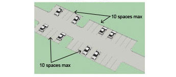
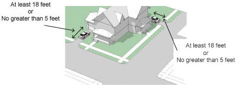
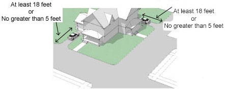
Effective on: 1/1/1901
SDS 6.16 Fencing & Walls
| Single Family | Multi-Family | ||||||
| RP-2 | R-2 | RP-3 | R-3 | RP-4 | RP-5 | RP-6 | |
SDS 6.16.1 Intent.
Fences and walls are sometimes used as a buffer. When provided, they shall be visually appealing and complement the design of both the overall development and surrounding properties.
Standard:
SDS 6.16.2 Setbacks.
Setbacks for fences and walls shall conform to the following table.
| Fence or Wall Type | Location | Fence or Wall Height | Required Setback |
|---|---|---|---|
| Transparent | Along a public right-of-way | Not greater than 8’ | 10’ min. |
| Along an interior property line | Not greater than 8’ | No min. | |
| Solid Screening | Along a public right-of-way | Not greater than 3’ | 4’ min. |
| Greater than 3’; not greater than 8’ | 15’ min. | ||
| Along an interior property line | Not greater than 8’ | No min. |
SDS 6.16.3 Height.
The maximum height of a fence or wall, including fences or walls used for buffer purposes, shall be eight (8) feet.
SDS 6.16.4 Materials.
Walls and fences shall be constructed of high quality materials, such as decorative blocks, brick, stone, treated wood, and ornamental metal. Other materials will be considered on a case-by-case basis. Chain link fencing is not allowed except around sports courts; the chain link shall be vinyl-coated. Fences and walls used for buffer purposes shall have the finished side face out.
SDS 6.16.5 Maximum Length.
The maximum length of a continuous and uninterrupted fence or wall plane shall be 40 feet. Interruptions in fence or wall planes shall be provided through the use of columns, landscaping pockets, transparent sections, and/or a change to different materials.
SDS 6.16.6 Landscaping.
The setback area between a fence or wall and the public street shall be landscaped with sod, shrubs, and/or trees, using a variety of species to display a variety of leaf size, texture, and color.
Effective on: 1/1/1901
SDS 6.17 Lighting: Residential
| Single Family | Multi-Family | ||||||
| RP-2 | R-2 | RP-3 | R-3 | RP-4 | RP-5 | RP-6 | |
SDS 6.17.2 Building-Mounted Lighting.
Building-mounted lighting shall be used only to highlight specific architectural features; maximum height shall be 20 feet.
Effective on: 1/1/1901
SDS 7.1 Pedestrian Realm
| Single Family | Multi-Family | Commercial | |||||||||||||
| RP-2 | R-2 | RP-3 | R-3 | RP-4 | RP-5 | RP-6 | CP-0 | C-0 | CP-1 | C-1 | CP-2 | C-2 | CP-3 | C-3 | |
SDS 7.1.1 Intent.
Walkways along building fronts and streets, drives, accessways, and parking lots shall be designed to enhance the pedestrian realm and ensure adequate space for uses provided within the pedestrian realm. The intent of the pedestrian realm standards is to provide both common pedestrian realm assemblies and provide direction for the minimal dimensions required to accommodate common items provided within the pedestrian realm.
SDS 7.1.2 Standard.
An application shall use the pedestrian realm standards for developing enhanced pedestrian realms along building fronts and streets, drives, and accessways.
SDS 7.1.3 Pedestrian Realm.
In commercial districts, the pedestrian realm shall be the area between the curb of a street, drive, accessway, or parking lot and the building facade. In residential districts, the pedestrian realm shall be the area between the curb of a street, drive, accessway, or parking lot and the outer edge of the sidewalk or the outer edge of the activity zone.
SDS 7.1.4 Pedestrian Realm Submittal.
Applications shall include dimensional standards for the pedestrian realm included along buildings, streets, drives, and accessways and shall indicate their location on a plan of the development.
SDS 7.1.5 Applicable Pedestrian Realms.
The pedestrian realm types on pages 94 through 100 are examples and might not be suitable in all developments. Each development will be reviewed to determine which pedestrian realm is most suited for that style of development or if there is another type. Title 13 of the Municipal Code identifies the required sidewalk dimensions. See the following pages for examples of pedestrian realm configuration.
Pedestrian Realm Zones.
SDS 7.1.6 Pedestrian Realm Zones.
The pedestrian realm is composed of three zones: the activity zone, the pedestrian zone, and the amenity zone.
SDS 7.1.7 Activity Zone.
The activity zone shall be the pedestrian realm from the building front to the edge of the pedestrian zone. The activity zone is the section of the pedestrian realm that is reserved for activities that commonly occur immediately adjacent to the building facade. Typical amenities or activities included in the activity zone include, but are not limited to, window shopping, benches, potted plants, dining, and outdoor shopping.
SDS 7.1.8 Pedestrian Zone.
The pedestrian zone is located between the activity zone and the amenity zone. The pedestrian zone is the section of the pedestrian realm that is reserved for pedestrian through-traffic.
SDS 7.1.9 Amenity Zone.
The amenity zone is located between the curb or pavement edge to the edge of the pedestrian zone. The amenity zone is the section that is reserved for activities that commonly occur between the adjacent curb or pavement edge and pedestrian through-traffic. Typical amenities included in the activity zone include, but are not limited to, street trees, benches, bus stops, dining tables, and bike racks.
| Pedestrian Realm Zones |
|---|
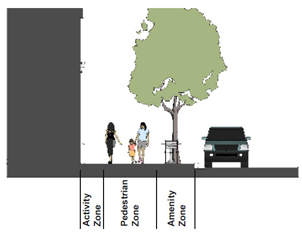 |
Pedestrian Realm Amenities.
SDS 7.1.10 Pedestrian Realm Amenities.
In order to not impede upon the pedestrian through-traffic and the parking or travel lanes, amenities provided in the pedestrian realm require a minimum amount of space within a zone. When planning for the location of desired amenities it is important to remember that amenities located in different pedestrian realm zones may require different areas due to the location of the zone. Minimum widths of common amenities according to their location are listed in the following table. Please note that the table contains widths that are the minimum necessary to accommodate the one specific item listed; regardless of the minimum listed below, developments shall consider the pedestrian realm widths necessary to accommodate the intended types and quantities of amenities.
| Minimum Width in This Zone: | ||
|---|---|---|
| Amenity | Activity Zone | Amenity Zone |
| Tree Well | N/A | 5’ |
| Tree Planter | N/A | 5’ |
| Tree Lawn | N/A | 5’ |
| Bench: parallel to building | 1’-6” | 3’ |
| Bench: perpendicular to building | 4’-6” | 5’-6” |
| Bus Stop with bench | N/A | 5’ |
| Bus Stop with shelter | N/A | 8’ |
| Dining: one single table | 3’ | 5’ |
| Dining: two single or one double table | 5’ | 7’ |
| Dining: four-person table | 6’ | 8’ |
| Sandwich Sign Board | 1’-6” | 3’ |
| Newspaper Vending Machine/Stand | 1’-6” | 3’ |
| Potted Plants | 1’-6” | 3’ |
| Bike Rack | N/A | 4’ |
SDS 7.1.11 Treeway.
| Single Family | Multi-Family | ||||||
| RP-2 | R-2 | RP-3 | R-3 | RP-4 | RP-5 | RP-6 | |
The treeway is the simplest of pedestrian realm types. It consists of a walkway lined with street trees planted in a tree lawn between a curb or paved area and a walkway. The treeway is appropriate for use along streets, drives, and private accessways in residential districts.
| Treeway Standards | |
|---|---|
| Applicable Districts | Residential |
| Pedestrian Realm Width | 11’ min. |
| Activity Zone Width | N/A |
| Pedestrian Zone Width | 5’ min. (See Title 13 of the Municipal Code) |
| Amenity Zone Width | 6’ min. |
| Treeway Amenities | |
|---|---|
| Within this Zone: | The Overall Realm Width Minimum Can Accommodate: |
| Activity Zone | N/A |
| Pedestrian Zone | Two-way pedestrian traffic |
| Amenity Zone | Street trees in a tree lawn |
| Treeway |
|---|
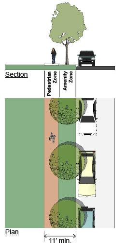 |
SDS 7.1.12 Alameda.
| Single Family | Multi-Family | Commercial | |||||||||||||
| RP-2 | R-2 | RP-3 | R-3 | RP-4 | RP-5 | RP-6 | CP-0 | C-0 | CP-1 | C-1 | CP-2 | C-2 | CP-3 | C-3 | |
The alameda is an enhanced form of the treeway pedestrian realm. It consists of a walkway lined with trees planted on both sides of a walkway. The alameda is appropriate for use along streets, drives, and accessways in residential districts; the alameda is also applicable along streets, drives, and accessways in commercial districts that do not have direct building frontage.
| Alameda Standards | |
|---|---|
| Applicable Districts | Residential; Commercial |
| Pedestrian Realm Width | 24’ min. |
| Activity Zone Width | 8’ min. |
| Pedestrian Zone Width | 8’ min. (See Title 13 of the Municipal Code) |
| Amenity Zone Width | 8’ min. |
| Alameda Amenities | |
|---|---|
| Within This Zone: | The Overall Realm Width Minimum Can Accommodate: |
| Activity Zone | Street trees in a tree lawn |
| Pedestrian Zone | Two-way pedestrian traffic |
| Amenity Zone | Street trees in a tree lawn |
| Alameda |
|---|
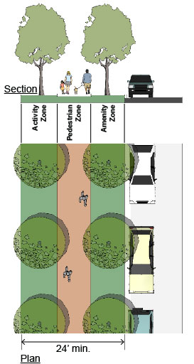 |
SDS 7.1.13 Paveway.
| Commercial | |||||||
| CP-0 | C-0 | CP-1 | C-1 | CP-2 | C-2 | CP-3 | C-3 |
The paveway consists of a paved walkway located between a building front and the curb or paved area. The paveway is lined with street trees planted in tree wells or planters located between a curb or paved area and the pedestrian zone. The paveway is appropriate for use along streets, drives, and private accessways in commercial districts.
| Paveway Standards | |
|---|---|
| Applicable Districts | Commercial |
| Pedestrian Realm Width | 12’ min.; 15’ max. |
| Activity Zone Width | 1’-6” min. |
| Pedestrian Zone Width | 4’ min. (See Title 13 of the Municipal Code) |
| Amenity Zone Width | 5’ min. |
| Paveway Amenities | |
|---|---|
| Within This Zone: | The Overall Realm Width Minimum Can Accommodate: |
| Activity Zone | Window shopping, benches, potted plants, single table dining |
| Pedestrian Zone | Two-way pedestrian traffic |
| Amenity Zone | Street tree in tree wells or planters, benches, bike racks, bus stop with bench, single table dining, potted plants |
| Paveway |
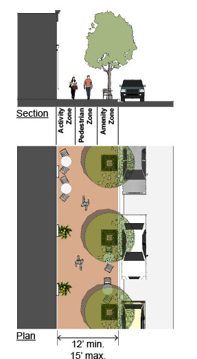 |
SDS 7.1.14 Gallery.
| Commercial | |||||||
| CP-0 | C-0 | CP-1 | C-1 | CP-2 | C-2 | CP-3 | C-3 |
The gallery is an enhanced form of the paveway pedestrian realm. The gallery consists of a paved walkway located between a building front and the curb or paved area that is covered by a ceiling or roof. Since shade is provided by the ceiling or roof, the gallery does not typically contain street trees. The gallery is appropriate for use along streets, drives, and private accessways in commercial districts.
| Gallery Standards | |
|---|---|
| Applicable Districts | Commercial |
| Pedestrian Realm Width | 12’ min.; 15’ max |
| Covered Width | 8’ min. |
| Activity Zone Width | 1’-6” min. |
| Pedestrian Zone Width | 4’ min. (See Title 13 of the Municipal Code) |
| Amenity Zone Width | 5’ min. |
| Gallery Amenities | |
|---|---|
| Within This Zone: | The Overall Realm Width Minimum Can Accommodate: |
| Activity Zone | window shopping, benches, single table dining |
| Pedestrian Zone | two-way pedestrian traffic |
| Amenity Zone | benches, bike racks, bus stop with bench, single table dining, potted plants |
| Gallery |
|---|
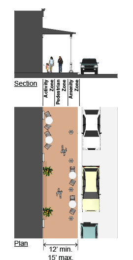 |
SDS 7.1.15 Promenade.
| Commercial | |||||||
| CP-0 | C-0 | CP-1 | C-1 | CP-2 | C-2 | CP-3 | C-3 |
The promenade consists of a wide paved walkway located between a building front and the curb or paved area. The promenade is lined with street trees planted in tree wells or planters located between a curb or paved area and the pedestrian zone. The promenade is appropriate for use along streets, drives, and private accessways in commercial districts.
| Promenade Standards | |
|---|---|
| Applicable Districts | Commercial |
| Pedestrian Realm Width | 15’ min. |
| Activity Zone Width | 1’-6” min. |
| Pedestrian Zone Width | 4’ min. (See Title 13 of the Municipal Code) |
| Amenity Zone Width | 5’ min. |
| Promenade Amenities | |
|---|---|
| Within This Zone: | The Overall Realm Width Minimum Can Accommodate: |
| Activity Zone | Window shopping, benches, potted plants, dining, outdoor shopping |
| Pedestrian Zone | Two-way pedestrian traffic |
| Amenity Zone | Street tree in tree wells or planters, benches, bike racks, bus stop with bench or shelter, dining, potted plants, outdoor shopping |
| Promenade |
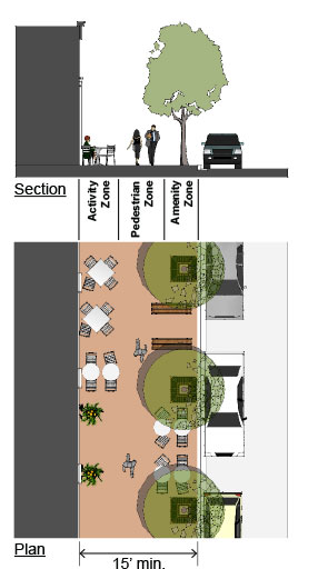 |
SDS 7.1.16 Marketway.
| Commercial | |||||||
| CP-0 | C-0 | CP-1 | C-1 | CP-2 | C-2 | CP-3 | C-3 |
The marketway is an enhanced form of the promenade pedestrian realm. The marketway consists of a paved walkway located between a building front and the curb or paved area that is covered by a ceiling or roof. Since shade is provided by a ceiling or roof, the gallery does not typically contain street trees. The marketway is appropriate for use along streets, drives, and private accessways in commercial districts.
| Marketway Standards | |
|---|---|
| Applicable Districts | Commercial |
| Pedestrian Realm Width | 15’ min. |
| Covered Width | 12’ min. |
| Activity Zone Width | 1’-6” min. |
| Pedestrian Zone Width | 4’ min. (See Title 13 of the Municipal Code) |
| Amenity Zone Width | 5’ min. |
| Marketway Amenities | |
|---|---|
| Within This Zone: | The Overall Realm Width Minimum Can Accommodate: |
| Activity Zone | Window shopping, benches, dining, outdoor shopping |
| Pedestrian Zone | Two-way pedestrian traffic |
| Amenity Zone | Benches, bike racks, bus stop with bench, dining, potted plants, outdoor shopping |
| Marketway |
|---|
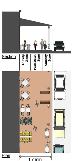 |
SDS 7.1.17 Curbway.
| Commercial | |||||||
| CP-0 | C-0 | CP-1 | C-1 | CP-2 | CP-3 | C-3 | |
The curbway is pedestrian realm allowed for use along streets, drives, and private accessways in redeveloping commercial areas with restricted pedestrian realm dimensions. The curbway consists of a paved walkway located between a building front and the curb or paved area. Street trees are planted in “bulb-outs” located in the parking area next to the curb.
| Curbway Standards | |
|---|---|
| Applicable Districts | Commercial Redevelopment |
| Pedestrian Realm Width | 6’ min. |
| Activity Zone Width | 1’-6” min. |
| Pedestrian Zone Width | 4’-6” min. (See Title 13 of the Municipal Code) |
| Amenity Zone Width | N/A; street trees provided by “bulb- outs” |
| Curbway Amenities | |
|---|---|
| Within This Zone: | The Overall Realm Width Minimum Can Accommodate: |
| Activity Zone | Window shopping, benches, potted plants |
| Pedestrian Zone | Two-way pedestrian traffic |
| Amenity Zone | N/A; street trees provided by “bulb-outs” |
| Curbway |
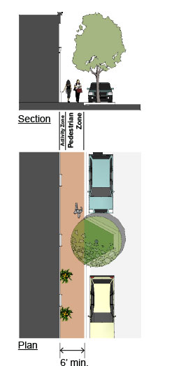 |
Effective on: 1/1/1901
SDS 7.2 Incentives
| Single Family | Multi-Family | ||||||
| RP-2 | R-2 | RP-3 | R-3 | RP-4 | RP-5 | RP-6 | |
SDS 7.2.1
SDS 7.2.1.1 Intent.
Incentives encourage development that provides an increase in landscaping or common open space, creates a neighborhood green, or uses a specified stormwater management technique.
| Section | Incentive | Maximum Bonus Density Awarded (See Section SDS 6.2.1) |
Awards a Lot Coverage Bonus | Applicable Standard Reference Section |
|---|---|---|---|---|
| SDS 7.2.2 | Providing a Housing Type Mix | 20% | N/A | |
| SDS 7.2.3 | Providing Additional Common Open Space | 20% | SDS 6.5 | |
| SDS 7.2.4 | Creating a Neighborhood Green | 5 - 20% | N/A | |
| SDS 7.2.5 | Preserving Additional Existing Trees | 5 - 20% | SDS 4.3 | |
| SDS 7.2.6 | Upgrading a Stream Corridor | 20% | SDS 4.2 | |
| SDS 7.2.7 | Preserving Additional Natural Areas or Cultural Features |
20% | SDS 4.1 | |
| SDS 7.2.8 | Increasing Site Perimeter Landscaping | 10% | SDS 4.11 | |
| SDS 7.2.9 | Increasing Tree Caliper | 10% | SDS 4.9-SDS 4.14 | |
| SDS 7.2.9 | Increasing Tree Height | 10% | ||
| SDS 7.2.9 | Increasing Quantity of Trees | 5% | ||
| SDS 7.2.10 | Providing Below-Grade or Structured Parking |
20% | SDS 4.8 | |
| SDS 7.2.11 | Providing Pervious Pavings | 20% | X | SDS 4.5 & SDS 6.3 |
| SDS 7.2.11 | Providing Vegetated Roofs | 20% | X | |
| SDS 7.2.11 | Providing Rainwater Harvesting & Reuse | 10% | SDS 4.5 | |
| SDS 7.2.11 | Providing Solar Reflective Roofs | 10% | ||
| SDS 7.2.11 | Providing Solar Reflective Paved Areas | 10% | ||
| SDS 7.2.11 | Providing Shaded Paved Areas | 10% |
- See Architectural Design Standards for additional incentives.
- Maximum Density awards may be pro-rated.
SDS 7.2.2 Housing Type Mix Incentive
| Single Family | Multi-Family | ||||||
| RP-2 | R-2 | RP-3 | R-3 | RP-4 | RP-5 | RP-6 | |
SDS 7.2.2.1 Intent.
A development with a mixture of dwelling types should be awarded a development bonus.
SDS 7.2.2.2 Incentive.
The city may award up to a 20% increase in the maximum density for providing a mixture of dwelling types. The development must include at least three of the following dwelling types; each dwelling type shall compose at least 10% of the total number of units.
- Multi-Family Dwellings containing at least 3 units per building
- Single-Family Detached Dwellings
- Two-Family Dwellings
- Townhome Dwellings
SDS 7.2.3 Common Open Space Incentive
| Single Family | Multi-Family | ||||||
| RP-2 | R-2 | RP-3 | R-3 | RP-4 | RP-5 | RP-6 | |
SDS 7.2.3.1 Intent.
A development with additional common open space should be awarded a development bonus.
SDS 7.2.3.2 Incentive.
The city may award up to a 1% increase in the maximum density per each 1% of net site area provided as common open space above the minimum required common open space.
SDS 7.2.3.3 Neighborhood Greens.
For the purposes of calculating this incentive, a development using the neighborhood green incentive shall not include any area included in the neighborhood green as part of its total net site area used as common open space.
SDS 7.2.3.4 Maximum Bonus.
This incentive is limited to a maximum 20% increase in maximum density.
SDS 7.2.4 Neighborhood Green Incentive
| Single Family | Multi-Family | ||||||
| RP-2 | R-2 | RP-3 | R-3 | RP-4 | RP-5 | RP-6 | |
SDS 7.2.4.1 Intent.
A development that creates a neighborhood green should be awarded a development bonus.
SDS 7.2.4.2 Incentive.
An 10% increase in maximum density may be awarded for a development containing a neighborhood green according to the following table.
| For This Development Area: | The Green Shall Be No Smaller Than: |
|---|---|
| Less than 25 acres | 1/4 acre |
| At least 25 acres; less than 60 acres | 1/2 acre |
| At least 60 acres | 3/4 acre |
SDS 7.2.4.3 Common Open Space Classification.
A neighborhood green shall be classified as a designed open space and shall meet all design criteria for a designed open space.
SDS 7.2.4.4 Location.
- The neighborhood green shall be centrally located and easily accessible to both the public and the residents within the development.
- The neighborhood green shall be in a visible, secure setting that is easily observed from streets or private drives. If possible, the green shall be bordered by public and/or private streets.
- Only building fronts shall face onto a green.
- All parts of the green shall be easily accessible by pedestrians.
SDS 7.2.4.5 Amenities and Landscaping.
Each neighborhood green shall be landscaped and may contain walking paths, plazas, pavilions, picnic tables, or benches. Neighborhood greens shall be separate from clubhouses, swimming pools, or sports courts.
| Amenities and Landscaping |
|---|
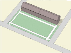
Attached Green |
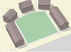
Courtyard Green |
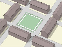
Square Green |
SDS 7.2.5 Preservation of Existing Trees Incentive
| Single Family | Multi-Family | ||||||
| RP-2 | R-2 | RP-3 | R-3 | RP-4 | RP-5 | RP-6 | |
SDS 7.2.5.1 Intent.
A development that preserves additional significant trees should be awarded a development bonus.
SDS 7.2.5.2 Incentive.
The city may award up to a 5% increase in the maximum density per each ten 10% of significant trees preserved above the required minimum.
SDS 7.2.5.3 Maximum Bonus.
This incentive is limited to a maximum 20% increase in maximum density.
SDS 7.2.6 Stream Corridor Upgrade Incentive
| Single Family | Multi-Family | ||||||
| RP-2 | R-2 | RP-3 | R-3 | RP-4 | RP-5 | RP-6 | |
SDS 7.2.6.1 Intent.
A development that provides an upgrade to a stream corridor should be awarded a development bonus.
Incentive:
SDS 7.2.6.2 Density Bonus.
The city may award up to a 10% percent increase in the maximum density for a development that upgrades a stream corridor. The upgrade must be completed so that it would be rated as “excellent” quality in accordance with the Overland Park Stream Riparian Corridor Quality Evaluation form.
SDS 7.2.6.3 Applicability.
In order to receive the full density bonus, the improved stream corridor must be 5% of the total net development acreage. The bonus may be prorated for improved stream corridors of less than 5% of the total net development acreage.
SDS 7.2.7 Natural & Cultural Feature Incentive
| Single Family | Multi-Family | ||||||
| RP-2 | R-2 | RP-3 | R-3 | RP-4 | RP-5 | RP-6 | |
SDS 7.2.7.1 Intent.
A development that preserves additional significant natural, historic, or cultural features should be awarded a development bonus.
SDS 7.2.7.2 Incentive.
The city may award up to a 10% percent increase in the maximum density for preservation of significant natural, historic, or cultural features; integration of the feature in the overall site plan concept is required.
SDS 7.2.8 Site Perimeter Landscaping Incentive
| Single Family | Multi-Family | ||||||
| RP-2 | R-2 | RP-3 | R-3 | RP-4 | RP-5 | RP-6 | |
SDS 7.2.8.1 Intent.
A development that provides additional site perimeter landscaping should be awarded a development bonus.
SDS 7.2.8.2 Incentive.
The city may award up to a 10% percent increase in the maximum density for site perimeter landscaping provided at a ratio of eight (8) evergreen (conifer) trees, two (2) shade trees, and one (1) ornamental tree per 100 linear feet of edge, with fractional requirements rounded up.
SDS 7.2.8.3 Applicability.
This incentive shall not be awarded if an incentive is awarded for an increase in the number of trees for parking lot landscaping.
SDS 7.2.9 Landscaping Incentives
SDS 7.2.9.1 Intent.
A development that increases the quality or quantity of trees planted should be awarded a development bonus.
SDS 7.2.9.2 Incentive.
An increase in maximum density may be allowed for a development containing additional landscaping according to the following table.
| For Providing: | Up To This Amount May Be Awarded: |
|---|---|
| An increase in tree caliper size for all deciduous trees provided. | 10% increase in maximum density per one (1) inch tree caliper increase |
| An increase in height for all evergreen trees provided. | 10% increase in maximum density per one (1) foot height increase |
| One additional tree per dwelling unit above the minimum landscaping required | 5% increase in maximum density; this incentive cannot be combined with Site Perimeter Landscaping Incentive |
SDS 7.2.10 Below-Grade or Structured Parking Incentive
| Single Family | Multi-Family | ||||||
| RP-2 | R-2 | RP-3 | R-3 | RP-4 | RP-5 | RP-6 | |
SDS 7.2.10.1 Intent.
A development that provides structured or below-grade parking should be awarded a development bonus.
SDS 7.2.10.2 Incentive.
The city may award up to a 20% percent increase in the maximum density for providing structured or underground parking. Parking structures shall be located underground (below-grade) or beneath the multi-family structure or integrated into the overall design of the structure. Garages located on the downhill side of a two/three split building do not qualify for this bonus.
SDS 7.2.11 Stormwater Management Incentives
| Single Family | Multi-Family | ||||||
| RP-2 | R-2 | RP-3 | R-3 | RP-4 | RP-5 | RP-6 | |
SDS 7.2.11.1 Intent.
A development that uses a specified stormwater technique should be awarded a development bonus.
SDS 7.2.11.2 Incentive.
A development bonus may be allowed for a development containing specified stormwater management techniques according to the following tables.
SDS 7.2.11.3 Prorated Bonuses.
For development bonuses awarding an increase in maximum density, the maximum credit shall be awarded for meeting the minimum area/volume requirements indicated; partial credit may be awarded on a prorated basis for providing less than the required area. For example, if pervious pavement is provided for 15% of all paved area, the credit would be (0.15/0.5) x 20% = 6%).
| For Providing: | According to These Standards: | This Development Bonus May Be Awarded: |
|---|---|---|
| Pervious Pavings |
|
|
| Vegetated Roofs |
|
|
| Rainwater Harvesting and Reuse |
|
|
| Solar Reflective Roofs (to reduce heat island effect and reduce stormwater run-off temperatures) |
|
|
| Solar Reflective Paved Area (to reduce heat island effect and reduce stormwater run-off temperatures) |
|
|
| Shaded Paved Areas (to reduce heat island effect and reduce stormwater run-off temperatures) |
|
|
Effective on: 1/1/1901
SDS 7.3 Definitions
| Single Family | Multi-Family | Commercial | ||||||||||||||||||
| RP-1N | RP-1A | R-1A | RP-1 | R-1 | RP-2 | R-2 | RP-3 | R-3 | RP-4 | RP-5 | RP-6 | CP-0 | C-0 | CP-1 | C-1 | CP-2 | C-2 | CP-3 | C-3 | |
Adjacent or Abutting: to physically touch, border upon, or share a common property line or border. “Adjacent” or “abutting” shall not include properties or uses that are separated by a public, dedicated right-of-way.
Effective on: 1/1/1901
Accessory Structure: a structure detached from and customarily used with a principal building or structure. An accessory structure is clearly incidental and subordinate to the principal building or structure and is ordinarily located on the same lot as the principal building or structure.
Effective on: 1/1/1901
Berm: an earthen mound designed to provide visual interest, screen undesirable views, decrease noise, and/or control or manage surface drainage.
Effective on: 1/1/1901
Block Face: the properties abutting one side of a street and lying between the nearest intersections of the street with another street, railroad right-of-way, stream corridor, unsubdivided land, or other similar interruption to the lots and/or parcels.
Effective on: 1/1/1901
Carport: an accessory structure used for the parking of motor vehicles; a carport has a roof, but is distinguished from a garage in that a carport is enclosed on no more than three sides.
Effective on: 1/1/1901
Garage: an accessory structure or portion of a primary building or structure primarily used for the storage of motor vehicles; a garage is distinguished from a carport in that a garage is enclosed on more than three sides and the motor vehicle is contained entirely with the structure.
Effective on: 1/1/1901
Pad Site Building: a building or building site that is physically separate from the primary building or structure and reserved for a free-standing commercial use; the use contains a gross floor area of no more than 15,000 square feet. A pad site building is generally constructed in conjunction with a retail shopping center development and typically consists of a free-standing restaurant, bank, or auto service.
Effective on: 1/1/1901
Primary or Principal Building: the building or structure on a lot or parcel used to accommodate the primary permitted use; a lot or parcel may contain more than one primary or principal building.
Effective on: 1/1/1901
SDS 7.4 Checklist
Commercial
| Commercial | |||||||
| CP-0 | C-0 | CP-1 | C-1 | CP-2 | C-2 | CP-3 | C-3 |
| Checklist: Commercial | ||||
| Date: | ||||
| Applicant: | ||||
| Zoning District: | ||||
-checkboxes.jpg) |
||||
| Section | Standard | Y | N | N/A |
| SDS 4.1 | Preservation of Natural Areas & Cultural Features | |||
| SDS 4.2 | Protection of Stream Corridors & Wetlands | |||
| SDS 4.3 | Preservation of Existing Trees & Vegetation | |||
| SDS 4.4 | Grading & Retaining Walls | |||
| SDS 4.5 | Stormwater Management | |||
| SDS 4.6 | Setbacks | |||
| SDS 4.7 | Pedestrian Access & Circulation | |||
| SDS 4.8 | Parking | |||
| SDS 4.9 | Plant Materials | |||
| SDS 4.10 | Street Trees | |||
| SDS 4.11 | Site Perimeter Landscaping | |||
| SDS 4.12 | Site Entryway Landscaping | |||
| SDS 4.13 | Parking Lot Perimeter Landscaping | |||
| SDS 4.14 | Parking Lot Landscaping | |||
| SDS 4.15 | Signage | |||
| SDS 4.16 | Screening | |||
| SDS 4.17 | Service Compatibility | |||
| SDS 5.1 | Transitions between Land Uses | |||
| SDS 5.2 | Sites at Intersecting Thoroughfares | |||
| SDS 5.3 | Development Patterns | |||
| SDS 5.4 | Single Building Developments | |||
| SDS 5.5 | Pad Sites | |||
| SDS 5.6 | Drive-throughs, Canopies, Kiosks, & ATM Structures | |||
| SDS 5.7 | Site Amenities | |||
| SDS 5.8 | Walkways along Buildings & Parking Areas | |||
| SDS 5.9 | Street Connections: Commercial | |||
| SDS 5.10 | Vehicle Access & Circulation: Commercial | |||
| SDS 5.11 | Vehicle Entrances | |||
| SDS 5.12 | Service Access & Circulation: Commercial | |||
| SDS 5.13 | Parking Location & Layout: Commercial | |||
| SDS 5.14 | Lighting: Commercial | |||
| Comments: |
||||
Multi-Family
| Multi-Family | |||||||
| RP-2 | R-2 | RP-3 | R-3 | RP-4 | RP-5 | RP-6 | |
| Checklist: Multi-Family | |||||
| Date: | |||||
| Applicant: | |||||
| Zoning District: | |||||
-checkboxes.jpg) |
|||||
| Section | Standard | Y | N | N/A | |
| SDS 4.1 | Preservation of Natural Areas & Cultural Features | ||||
| SDS 4.2 | Protection of Stream Corridors & Wetlands | ||||
| SDS 4.3 | Preservation of Existing Trees & Vegetation | ||||
| SDS 4.4 | Grading & Retaining Walls | ||||
| SDS 4.5 | Stormwater Management | ||||
| SDS 4.6 | Setbacks | ||||
| SDS 4.7 | Pedestrian Access & Circulation | ||||
| SDS 4.8 | Parking | ||||
| SDS 4.9 | Plant Materials | ||||
| SDS 4.10 | Street Trees | ||||
| SDS 4.11 | Site Perimeter Landscaping | ||||
| SDS 4.12 | Site Entryway Landscaping | ||||
| SDS 4.13 | Parking Lot Perimeter Landscaping | ||||
| SDS 4.14 | Parking Lot Landscaping | ||||
| SDS 4.15 | Signage | ||||
| SDS 4.16 | Screening | ||||
| SDS 4.17 | Service Compatibility | ||||
| SDS 6.1 | Lot Width, Depth, & Orientation | ||||
| SDS 6.2 | Maximum Density | ||||
| SDS 6.3 | Lot Coverage | ||||
| SDS 6.4 | Building Orientation | ||||
| SDS 6.5 | Common Open Space: Area & Type | ||||
| SDS 6.6 | Designed Open Space: Shape & Content | ||||
| SDS 6.7 | Common Open Space: Accessibility | ||||
| SDS 6.8 | Site Amenities: Developments of at least 3 acres | ||||
| SDS 6.9 | Site Amenities: Developments of less than 3 acres | ||||
| SDS 6.10 | Street Connections: Multi-Family | ||||
| SDS 6.13 | Private Drives & Accessways | ||||
| SDS 6.14 | Vehicle Access & Circulation: Residential | ||||
| SDS 6.15 | Parking Location & Layout: Residential | ||||
| SDS 6.16 | Fencing & Walls | ||||
| SDS 6.17 | Lighting: Residential | ||||
| Comments: |
|||||
Single-Family
| Single Family | |||||
| RP-1N | RP-1A | R-1A | RP-1 | R-1 | |
| Checklist: Single Family | |||||
| Date: | |||||
| Applicant: | |||||
| Zoning District: | |||||
-checkboxes.jpg) |
|||||
| Section | Standard | Y | N | N/A | |
| SDS 4.1 | Preservation of Natural Areas & Cultural Features | ||||
| SDS 4.2 | Protection of Stream Corridors & Wetlands | ||||
| SDS 4.5 | Stormwater Management | ||||
| SDS 4.6 | Setbacks | ||||
| SDS 4.7 | Pedestrian Access & Circulation | ||||
| SDS 4.8 | Parking | ||||
| SDS 4.9 | Plant Materials | ||||
| SDS 4.10 | Street Trees | ||||
| SDS 4.12 | Site Entryway Landscaping | ||||
| SDS 6.1 | Lot Width, Depth, & Orientation | ||||
| SDS 6.11 | Street Connections: Planned Single-Family | ||||
| SDS 6.12 | Street Connections: Unplanned Single-Family | ||||
| SDS 6.14 | Vehicle Access & Circulation: Residential | ||||
| Comments: |
|||||
Effective on: 1/1/1901